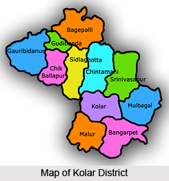
Kolar district, lying in the Karnataka state, is one such district that has easily drawn the attention of tourists from all over the country. To many Kolar district is identified as Gold Land of India. This is due to the recent discovery of major gold mines that have been built in hook and corner of the region.
History of Kolar District
The rich historical heritage of Kolar district has been highly acclaimed in all over the region. There has been no denying of the fact that it is a hub of numerous dynasties that have ruled here at different times.
Till 9th century Banas and Ganga dynasty have established their dominion. Also the famous Chola kings took possession of Kolar district around 1000 CE. The rulers of the later period who have reigned in Kolar are Hoysala Empire and Vijayanagara. Bijapur of Deccan region and then Wodeyars of Mysore succeeded them. Centering on this Kolar district, legends and myths are widely popular amongst the people. Most of these stories and saying are linked to great Indian epics of Ramayana and Mahabharata. One such belief is that after his triumphant feat and on his return to Ayodhya from Lanka Rama resides temporarily in Kolar district.
 Geography of Kolar District
Strategic location of Kolar district acts as its identifiable mark. It stretches up to an approximate area of 8,225 sq. km, lying tentatively at 77 degree and 21 minutes to 35 degree east longitude and 12 degree and 46 minutes to 13 degree and 58 minutes north latitude.
Kolar district is located in the southern region of the State and happens to be the eastern-most district of the Karnataka State. Other districts act as boundaries to Kolar district. For example, Bangalore and Tumkur districts form the western boundaries. Also some other districts of near by states like Andhra Pradesh and Tamil Nadu also bounded Kolar district from all possible sides.
To take for instance Anantapur district cushions Kolar district on the north; Chittoor district of Andhra Pradesh and Tamil Nadu`s Krishnagiri and Vellore districts lies on the eastern sides and south respectively. The highest length of Kolar district stretches to about 135 km from north to south.
From east to western sides as well the district covers the same distance. . It Mysore, which border the Eastern Ghats also is a part of Kolar district. Other features of Kolar district is that it is transacted by several mountains and summits of varied ranges, especially in its northern side.
Kolar districts`s major mountain chains include Nandidurga range running north from Nandi towards Andhra Pradesh`s Penukonda and Dharmavaram. Lands of Kolar district are prone to droughts and therefore dry with less rainfall. In Kolar district also rivers are small, stonily fed and mostly originated in high regions. Rivers, namely Palar River, Uttara Pinakini River and Dakshina Pinakini River deserve to be worth mentioning.
Culture of kolkar District
Festivals are an integral part of Kolar district. Each and every person of the district gets enthralled with the gala mood of festivals like Karaga, Theppothsava, Dyavara. To sustain their living people in this Kolar district have adapted to several occupations. Apart from the resources of gold mines many people also have been dependant on agriculture, dairy and sericulture. Due to this reason Kolar district also been popularized as the land of "Silk, Milk and Gold". Agriculture also is practiced. Thus cultivators fully utilize bore well water for irrigational as well drinking facilities.
Tourism in Kolar District
Kolar district is an ideal destination for the devotees since quite a few temples have been constructed here as well as in the adjacent region. In places like Kurudumale and Mulbagal exquisite temples to Someshwara are built. Near Mulbagal there is also Virupakshapura, which also is an abode of Virupaksha temple. All these temples of Kolar district were built during Vijayanagar Empire bearing its style and tradition.


