 Khag is a tehsil headquarter in central Kashmir valley of Budgam District of Jammu and Kashmir. Khag is also known for its springs and according to locals as many as 35 springs are there in Khag. The ancient people of Khag have defined it as the "Garden of Paradise".
Location of Khag
Khag is a town, municipality and Block in Badgam district in the Indian state of Jammu & Kashmir. Khag is located about 35 km West from State summer capital Srinagar and about 45 km from district headquarters in Budgam District of Jammu and Kashmir.
Administration of Khag
Initially Khag was one of the blocks of Beerwah Tehsil, after the Government of Jammu and Kashmir opened new administrative units in 2008, Khag was granted tehsil status.
Geography of Khag
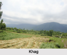
Khag is located at an elevation of 8,000 to 14,000 ft above sea level. It is surrounded by mountains measuring 17,000 ft in height between 75 degree East longitude and 33 degree North latitude at the base of the Pir Panjal Range. The place is covered with greenery and during summers shepherds in large numbers bring their sheep here for grazing. The region contains forest areas with several mountain and snow fed rivers and streams, including the Mala Kol, Kunze Kol, Nala Gogaldara. The Mala Kol is locally known as the "deaf and dumb stream" due to a legend that when saint Syed Taj-ud-Din arrived in Khag, the stream silently followed him from Sukhnag to Sikandarpora. Local elders continue to tell stories about other local streams.
Demography of Khag
Khag has a population of 6,663 of which 3401 are males while 3,262 are females as per Population Census 2011. In Khag village population of children with age 0-6 is 1479 which makes up 22.20 % of total population of village. Average Sex Ratio of Khag village is 959 which is higher than Jammu and Kashmir state average of 889. Child Sex Ratio for Khag as per census is 931, higher than Jammu and Kashmir average of 862.
Education of Khag
Khag has a lower literacy rate compared to Jammu and Kashmir. In 2011, literacy rate of Khag was 63.00 % compared to 67.16 % of Jammu and Kashmir. Male literacy stands at 71.35 % while female literacy rate was 54.37. Total of 45 villages with majority Sunni Muslim villages, 4 Sikh villages and 3 Shia Muslim villages. As of the 2011 census Khag had 856 families residing there.
Economy of Khag
Much of the local economy in Khag is agricultural. The crops grown include rice, mustard, vegetables, apples, walnuts, pears, apricots, cherries and almonds. The economy in Khag includes smaller businesses such as carpet design (Kaleen in the Kashmiri language), shawl design and knitwork and embroidery. Kashmiri carpets and shawls are marketed internationally, but due to increasing prices, family pressure and low income, local textile makers have shifted to other businesses.
Visiting Information
Khag is connected with State capital Srinagar in Srinagar District of Jammu and Kashmir via Aripanthan and Magam. It is also connected to Budgam district headquarters via Beerwah Degree College road through Kangripora and Drung, and also through Aripanthan-Beerwah road. The nearest Railway Station is Mazhama Railway Station about 19 km away. The closest airport is Srinagar International Airport about 55 km away.
Related Articles
Nature Tourism in Budgam District
Tourism in Budgam District
Budgam District
Jammu and Kashmir
Cities of Jammu and Kashmir