 There are various thoughts regarding the derivation of the name `Kasaragod`. According to one view it is the combination of two Sanskrit words "kaasaara", which means lake or pond and "kroda" that means a place where treasure is kept. Another view expresses that it is the place where Kaasaraka trees or Strychnos nux vomica or Kaanjiram or Kaaraskara are in abundance. But it can be seen that in both the there are large number of rivers, lakes and ponds in the coastal belt of the district. Besides which there is thick flora consisting of innumerable varieties of trees, shrubs etc. Particularly plenty of Kaasaraka trees are present in this locality.
Climate:
Temperature:
The district has a diversity of the physical features, which results into a corresponding diversity of climate.
The climate of the district can be classified as warm, humid and tropical. Where the average maximum temperature is 31.2oC and minimum is 23.6oC. Though the mean maximum temperature is only around 90oF,
the heat is oppressive in the moisture-loaded atmosphere of the plains. Humidity is very high and rises to about 90 percent during the southwest monsoon. The annual variation of temperature is small, the periodic range is only about 10oF.
Rainy Season:
The mean annual rainfall of the district can be said as 3581mm. This is regarded as highest in the state while the state average is 3063mm. The southwest monsoon starts towards the end of May or the beginning of June. This continues with the thunderstorm and hold till September when the monsoon fades out. The northeast monsoon can be brought by October-November. Out of the total rainfall specifically the months of June, July and August experiences 2/3 of the quantity. Dry weather in this district lasts from December to February. Where March to May is the hot season. The coolest months of the year are January-February.
Demography:
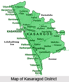
The total geographical area in the district is about 1992 sq. km. There are two taluks namely Kasargod and Hosdurg present in the district. There are all total 75 numbers of revenue villages and two municipalities present in the district. The municipalities are present in Kosaragod and Kanhangad. There are different blocks as well as 39 numbers of panchayats. There are 234 post offices and telephone exchange and T.V. stations are also there.
According to 2001 Census the total population of the district is 12,03,342. Out of which 5,87,763 are males and 6,15,579 are females. The density per sq. km is 604. Sex ratio per 1000 males is 1047.
Geography:
The district is marked off from the adjoining areas outside the State by the Western Ghats. The Western Ghats run parallel to the sea and constitute an almost continuous mountain wall on the eastern side. The Ghats dominate the topography of the district. The coastline is surrounded with low cliffs alternating with stretches of sand. A few miles to the interior, the scene changes and the sand level rises towards the barrier of the Ghats. This also transforms into low red laterite hills placed with paddy fields and coconut gardens.
The district falls into three natural division based on physical features, these can be named as The low land, which borders the sea, the mid land consisting of the undulating country and the forest, and the clad high land on the extreme east. There are mainly four types of soils present in the district namely, sandy, sand loam, laterite and hill or forest soil. The sandy and the sandy loam soils exist as a continuous narrow belt all along
the Western coast about 20 Km in width.
The land of the district can be categorized in detail as follows.
• Steeply slopy hill lands,
• Upland plateau,
•Deep gorges with steep side slopper and very narrow valleys.
•Border valleys bounded by subdued hills,
•Coastal plain and marine plain
• Nearly level lowland plains along the coastal plain.
Rivers:
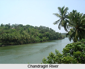
There are 12 rivers in this district. Out of which the longest is Chandragiri whose length is 105 km originating from Pattimala in Coorg. It embraces the sea at Thalangara, near Kasargod. It is assumed that the name of the river Chandragiri has taken from the name of the place of its source Chandragupta Vasti. This is the place where the great Maurya emperor Chandragupta is believed to have spent his last days as a sage.
The second longest river is Kariankod, which is 64 km in length. Across this river there is a dam, which is being built at Kakkadavu. The name of some of the other rivers and their lengths are given below: Shiriya is 61 km in length, Uppala is 50 km lengthy, Mogral is 34 km in length, Chithari is 25 km lengthy, Nileshwar (47 kms), Kavvayi (23 kms), Manjeswar (16 kms), Kumbala (11 kms), Bekal (11 kms) and Kalanad (8 kms).
These rivers provide ample irrigation facilities in the district.
Reserve forests:
Adoor, Eleri, Karudukka, Maloth, Parappa, Panathady and Muliyar are some of the reserve forests in the district. These forest areas have different types of medicinal plants and shrubs as well.
Mangrove forests (kandal kadukal):
In earlier days the river-sea joining lands were abundant with these forests. But now they are seen only in Chittari, Manjeshwar, Mogral, Uppala, Shiriya rivers.
Cultural heritage:
Kasargod offers a variety of patterns of arts, which speaks volumes about the rich cultural heritage of regions. The symphonic melody created by Yakshgana, Kambala or buffallo race, Cockfight etc. of the Thulanad culture, thrilling along with poorakkali, Kolkali, Duff Mutt, Oppana etc. pleases the visitors.
Languages:
Kasargod is a land of different languages. The languages without script are also used here. Tulu, Kannada, Malayalam, Konkani, Tamil and other local languages are the popular among others.
People of Kasargod:
The People of this Kasaragod District have a uniqueness in personal appearance, fairness in complexion, regularity of features, clean habits and simple life. This feature is unique as this is absent in other parts of the state. The literacy rate of this district is low as compared to others but the passion for education is growing day by day. Some of the people in the District have cosmopolitan outlook and character because of the connection they had with the trade missions that used to visit this place years back.
Scheduled caste people:
 There are different types in case of scheduled caste people present in the district. These are as follows:
Mavilan, Vettuvan, Mogar, Pulayan, Chakliyas, Nalikedaya, Vannan, Malayan, Velan.
Major portion of the Scheduled Caste people are very poor and illiterate and they are always affected due to exploitation in all cluster. Most of this people are agricultural labourers. The government and several Social and Cultural institutions are implementing various schemes for the uplift and development of these peoples in the district. The Scheduled Caste peoples have their own customs and rituals, which they follow religiously.
Scheduled tribe population in the district:
There are four types of scheduled tribe people are present in the district. These can be named as follows:
Koragas, Maratis, Adiyans, and Malakkudiyas.
The Koragas are one of the most primitive tribes, living in Kasaragod Taluk only. The traditional occupation of these people is basket and skepe making. These people are backward financially, educationally and as well as culturally. Among them the Maratis are educationally and culturally forward in comparison to the other tribes in the district.
The Tribal Development Department is implementing many schemes for the development of the tribes in the District. Like the Scheduled Caste people, Scheduled Tribe people also maintain their own culture, customs and rituals.
Functions of tribal development office of kasargod district can be mentioned as follows:
Implementation of Economic Development Schemes and Welfare schemes of Scheduled Tribes,
Distribution of Educational concession to Pre-matric & Post-matric Scheduled Tribe students,
Conduct medical and awareness camps in the settlement; and
Conduct youth festivals and cultural programmes.
District administration:
In earlier days Kasaragod district was part of South Kanara district of Madras state. On 1st November 1956, the Kasaragod taluk was made part of the re-organized Malabar district of Kerala state. Two months later on 1st January 1957, the present region covered by Kasaragod district became a part of the newly formed Cannanore, which is now a day known as Kanoor district. Along with it the former Kasaragod taluk was bifurcated into Kasaragod and Hosdurg taluks. In 1984 Kasaragod became a new district with Kasaragod town as its headquarters.
Revenue:
For revenue administration, Kasargod district is divided into two taluks, five firkas, and 75 villages. Only Revenue Division in the district is Kasargod and the office is at Kanhangad.
The Collectorate functions at Vidyanagar. This is situated in Chengala Panchayath, which is located at the distance of l5 Km away from Kasargod town.
Infrastructure and economy:
Agriculture:
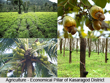
Agriculture is the most important support of the population of the district. The soil in the district can be divided into three different types, these are as follows: in the highland region it is laterite, in the midland, the soil is a red ferruginous loam of laterite origin with an admixture of clay and sand; whereas the coastal strip is sandy. Diversity of crops and heterogeneity in cultivation are the keynotes of agriculture here at this place.
The forests and hilly areas cover the whole eastern tract. The forests are full of variety of timber with teak and other plantations. The hilly areas are mostly cleared and put to private cultivation. The important crops include rubber, cashew and ginger. In the skeletal plateau areas, cashew trees are cultivated, while in some patches; areca nut, pepper and cocoa are grown. In the coastal tract mostly paddy, coconut, areca nut, cashew, tobacco, vegetable and tapioca are cultivated.
As compared to the production of the whole Kerala state, the share of the district is as follows:
Tobacco - 100%
Areca nut - 26%
Cashew nut - 16%
In case of Production data during the time of 1997-98
Agricultural production: 0.164 million tones.
Food grain production: 0.015 million tones.
Non-food grain production: 0.149 million tonnes.
Some of the important product raised and their extent can be described as follows:
Coconut is produced as 402 nuts per ha and the total area of cultivation is 55,271 ha. Cashew is cultivated in the area of 22,992 ha and the production is 21,669 nuts per ha. The production of rubber is 21,669 tonnes and the total cultivated area is 21, 265 ha.
Animal husbandry:
According to 1996 census, the numbers of livestock in the Kasaragod district is as follows:
The number of cattle present in this district is 1,92,866. The buffaloes are 9,397 in number, sheeps are 88, pigs are 4,734, etc.
Education:
The literacy rate of the district is 82.51%. There are adequate numbers of primary school and colleges are present in the disrtrict.
Forest:
There are two different types of forests present in this district. These are as follows:
Reserve forests:
Adoor, Eleri, Karudukka, Maloth, Parappa, Panathady and Muliyar are some of the reserve forests in the district. These forest areas have different types of medicinal plants as well as shrubs.
Mangrove forests or kandal kadukal:
In earlier days the river-sea joining lands were abundant with these forests. But now they are seen only in Chittari, Manjeshwar, Mogral, Uppala, Shiriya rivers.
Health:
In the field of health and sanitation, the district lacks modern facilities. Patients requiring technologically advanced treatment are forced to go to Manglore, Manipal or Kozhikode.
Industries:
Kasaragod district has vast potentials for the establishment of large and medium industries. But presently the district is industrially backward. There is no major industry here. As per the latest data available, there are 5,759 small-scale industrial units present in the district. There are 5,759 numbers of small-scale industry unit, no large-scale units whereas the numbers of medium industry are two. Industrial Co-op societies are 62 in numbers while handloom societies are eight in number.
Transport facility:
Railways, roadways as well as airways connect the city.
Railway:
The total length of the district is 116 km. There are all total twelve-railway stations present in the district.
By utilizing the Konkan Railway, the district has shortest access to important cities like Mumbai, New Delhi, Pune, Goa, Karwar, Manglore, Rajkot, etc. Almost all express trains have the stop at Kasargod and Kanhangad Railway stations. So it has been seen that all total more than 15 express trains and few passenger trains pass through this district.
Airport:
The nearest airport of the district is Mangalore in Karnataka, which is 50 km from district headquarters. There is another airport that is also used by the residents of Kasaragod district. This is placed at Kozhikode district and is 250 km far away.
 Roads:
The length of national highway is 86 km, state highway is 29 km, major districts Roads are 90 km, other district roads are 358km whereas village roads are 492 km.
Fisheries:
Kasargod district has eighty km long seacoast extending from Trikaripur to Bangra-Manjeshwar. There are many fish landing centers in this district and transporting facilities. The total numbers of fisheries present in the district are 16 while the number of fishermen are 42,772.
The name of some of the fishing villages which are prevalent in the district are as follows: Bangra-Manjeshwar, Shriya, Koipady, Kavugoly, Kasaba, Kizhur, Kottikilam, Pallikara, Ajanur, Hosdurg Kadappuram, Thaikadappuram, Punjavi Kadappuram, Padanna Kadappuram, Kadankod, Valiyaparamba and Trikaripur Kadapuram.
There is a lighthouse at Kasargod. There are also many ice plants in the public and private sectors.


