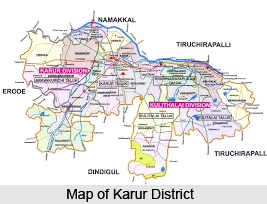
 Karur district was formed on the 30th of September 1995 by trifurcating Tiruchirapalli district. Karur taluk, which was once a part of Coimbatore district, was merged with Tiruchirapalli district during 1910. Initially, Karur district was carved out of the composite Tiruchirapalli district, consisting of three taluks namely, Kulithalai, Karur and Manaparai. Subsequently Manaparai taluk was decoupled and Musiri taluk was included in the district of Karur. Later Musiri taluk was decoupled from Karur district. Karur District, with headquarters at Karur, is the most centrally located district in the state of Tamil Nadu. It is about three hundred and seventy one kilometers to the southwest of Chennai (Madras), the capital of Tamil Nadu state. This district is bounded by Namakkal district to the north, Dindigul district to the south, Tiruchirapalli district to the east and the Erode District to the west. Karur district was formed through Government order 913 dated 30th September 1995.
History of Karur District
Karur was ruled by the Chola dynasty, the Chera dynasty, the Nayaks, and the British successively. There is proof that Karur may have been the centre for old jewellery-making and gem setting (gold imported mainly from Rome), as seen from several excavations. As per the Hindu mythology, Lord Brahma started the work of creation here, which is referred to as the `place of the sacred cow`. The district of Karur has a very long history and has been sung by a number of Sangam poets. In history, it has been the battleground of several Tamil Kings of different dynasties like the Cheras, the Pandyas, the Cholas and the Pallavas because of strategic location. The district has a very rich and varied cultural heritage. It is also a part of Kongunadu. The history of Kongunadu dates back to the eighth century. The name Kongunadu draws its origin from the term `Kongu`, meaning nectar or honey. Kongu was later called as Kongunadu with the growth of civilization. The ancient Kongunadu country was made up of a number of districts and taluks which are currently known as Palani, Karur, Dharapuram, Thiruchengodu, Erode, Pollachi, Nammakkal, Salem, Dharmapuri, Nilgiris, Avinashi, Satyamangalam, Coimbatore and Udumalpet. Kongunadu was blessed with huge wealth, a pleasant climate and distinct features. Kongunadu was ruled over by the Chera, Pandya, Chola, Hoysala, Muslim rulers and finally the British.

Geography of Karur District
Geography of Karur district is suitable for the cultivation of various crops and the economy of this district mainly depends on agriculture. This district of Tamil Nadu state has its headquarters at Karur. It is also the most centrally located district of the state of Tamil Nadu. This district is about three hundred and seventy one kilometers to the south-west of Chennai (Madras), the capital of Tamil Nadu. The district of Karur is surrounded by the Namakkal district to the north, Dindigul district to the south, Tiruchirapalli district to the east and the Erode district to the west.
Administration of Karur District
District Collector is the administrative head of the district and the office of the District Collector is the centre of district administration located in Master Plan Complex in Thanthondrimalai. It is about six kilometers from Karur bus stand and eight kilometers from Railway Station on the way to Dindigul via Vellianai. The district of Karur has two revenue divisions, four taluks, two municipalities, thirteen town panchayats and one hundred and fifty eight village panchayats and two hundred and three revenue villages. This district possesses four assembly constituencies of which one is a reserved and the reserved constituency is known as Krishnarayapuram constituency. Karur Parliamentary constituency constitutes six assembly constituencies, two are from Tiruchirappalli revenue district, namely Marungapuri and Thottiam and four assembly constituencies from Karur.
Tourism in Karur District
There are several places of interest for both nature lovers as well as pilgrims in the district of Karur. Karur district in the Tamil Nadu state of India is the most-centrally located districts of the state with its headquarters at Karur. The district is about three hundred and seventy one kilometers south-west of Chennai (Madras), the capital of Tamil Nadu state. It is bounded by Namakkal district in the north, Dindigul district in the south, Tiruchirapalli district on the east and the district of Erode on the west. The district of Karur has many big and old temples. There are several parks, river side parks, etc in the district which form some of the best tourist attractions in the state.
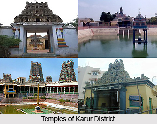
The temples of Karur District are among the best pilgrimage centers in the district with magnificent set of sculptures and architecture that not only reflect the religious domain of the district, but its artistic skills as well. Since Karur was an ancient battleground, the temples of Karur District reflect the sculptures of brave warriors.
 Some of the temples in this district are Shree Kalyana Pasupatheeswarar Temple, Shree Karuvur Mariyamman Temple, Vennaimalai Shree Balathandayuthapani Temple, Attur Sholiyamman Temple, Nerur Shree Sadhasiva Bhrameendhraal Temple, Mahadhanapuram Mahalaksmiamman Temple, Krishnarayapuram Tirukkanmalleswarar Temple, Kulithalai Kadambar Temple, Iyermalai Siva Temple, Lalapet Iyyapan Temple, Togamalai Murugan Temple, Vyakarapuriswarar temple, , Shree Abayapradhana Ranganathar Temple, Thanthondrimalai Shree Kalyana Venkataramanaswamy Temple, Pugazhimalai Shree Arupadai Murugan Temple, Vangal Shree Pudhu Vangalamman Temple, Madhukkarai Sellandiyamman Temple, Manmangalam Puthu Kaliyamman Temple, Kadavur Vasantha Perumal Temple, Kulithalai Neelameegha Perumal Temple, Shivayam Siva Temple, Lalapet Sri Jaya Anjaneya, Rangamalai Malleeshwarar Temple and many other temples.


