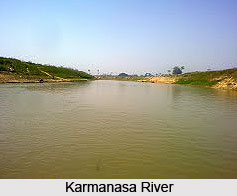
 Karmanasa River is a tributary of the Ganges River. Karmanasa River originates in Kaimur district of Bihar and flows through Uttar Prades. Along the boundary between Uttar Pradesh and Bihar, this river covers the districts like the Sonbhadra district, Chandauli district, Varanasi district and Ghazipur district on its left and the districts of Kaimur district and Buxar district on its right.
History of Karmanasa River
The name "Karmanasa" means "destroyer of religious merit". There are several legends on the river. According to mythological legend, the Indian sage Vishwamitra through meditation to God acquired the power to create a completely new universe. When he set out to create a new universe, it aroused consternation in Lord Indra. However, he continued and after creating a copy of our universe, he started creating people, the first being Trishanku whom he decided to send up to rule his new universe. Indra stopped his progress. That is how Trishanku ended up suspended head down in mid-air. The Karmanasa was born out of the saliva dripping from his mouth.
Karmanasa River originates at a height of 350 metres on the northern face of Kaimur Range near Sarodag in Kaimur district of Bihar. There it flows in a north-westerly direction through the plains of Mirzapur District, then forms the boundary between Uttar Pradesh and Bihar, and finally joins the Ganga River near Chausa where the battle of Chausa was fought.
Uttar Pradesh State Archaeology Department has unearthed iron artifacts near the coastal plain of Karanmasa River dated between 1200 - 1300 BC at Raja Nal Ka Tila site in Karmanasa river valley of north Sonebhadra district. It throws new light on the history of iron making in India. In the ancient times, this river formed the boundary between the ancient Aryans colonies of the north and the still unsubdued aboriginal tribes of the east. Karmanasa River was the eastern boundary of Awadh. It also possibly was the western boundary of the Sena dynasty. At the Battle of Chausa, situated on the banks of the Karmanasa River, on June 26, 1539, Sher Shah Suri defeated the mighty ruler of the Mughal dynasty, Humayun and assumed the royal title of Farid al-Din Sher Shah Suri.
Length of Karmanasa River
The length of the Karmanasa River is 192 kilometres. Out of which 116 kilometres lies in Uttar Pradesh state of India and the rest 76 kilometres forms the boundary between Uttar Pradesh and Bihar. The total drainage area of the Karmnasa River along with its tributaries is 11,709 square kilometres. The tributaries are the Durgavati River, the Chandraprabha River, the Karunuti River, the Nadi River and the Khajuri River.
Falls of Karmanasa River
Karanmasa River reaches the plains by a succession of leaps, including two falls known as the Devdari Falls and the Chhanpathar Falls. These two falls fall from their height with their beauty, are deserving of special notice from the inland and outland tourists. Chhanpathar Falls is 100 feet high. Devdari Falls, at an edge of the Rohtas Plateau, along the course of the Karmanasa River is 58 metres high. However, Chandauli district mentions that the Devdari Fall as being on the Chandraprabha River. There are two dams across the Karmanasa River - the Latif Shah Dam and the Nuagarh dam. There also is a dam across the Chandraprabha River.


