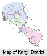
 Kargil District, with a headquarter at Kargil, is located very near to the Line of Control between India and Pakistan, covering some of the popular tourism attractions like Drass Valley, Leh District and Zanskar.
Location of Kargil District
Kargil district is located in the state of Jammu and Kashmir. Kargil district is situated near the Line of Control facing Pakistan-administered Kashmir`s Baltistan to the west, and Kashmir valley of Kashmir in India to the south.
History of Kargil District
The name Kargil is derived from two words Khar and rKil. Khar means castle and rKil means centre, thus, referring to a place between castles, as the place lay between many kingdoms. With the passage of time Khar-rKil came to be known as Kargil. It`s also believed that a pioneer namely Kargeel cleared the forests in Poyen and Shilikchay area before the advent of Thatha Khan, to dwell in the modern day Kargil and later the place assumed its name. Gasho Tha Tha Khan is said to be the first renowned crusader who established a dynasty in the area. In ancient era, the major part of present Kargil was named as Purik. The communities present here are Aryans, Dard, Tibetans and Mongoloids. Islam came to Kargil in 15th century. Mir Shams-ud-Din Iraqi, a scholar of Shia School of Central Asia visited Baltistan and Kargil with his missionaries to preach Islam. Kargil became a separate district in the Ladakh region during the year 1979 when it was bifurcated from the erstwhile Leh district.
Geography of Kargil District
The total area of Kargil District is 14036 square kilometers. It is situated at a distance of 205 kilometers from Srinagar towards Leh. Kargil is called the land of Agas in the present day world. Kargil district is geographically positioned in the Himalayan Mountain Range, giving it a chill, temperate climate. The entire Kargil district is spread over 14,086 km. The Suru River flows through Kargil District. Kargil District is of high rocky mountain ranges, desert arid, snow bound and devoid of natural vegetation. It occupies unique position because of its high altitude area in the country which ranges from 8000 to 23000 ft. above the sea level.
Climate of Kargil District
The summers in Kargil District are warm with cool nights, while winters are long and cold with temperatures often dropping to -40 degrees Celsius with recorded temperatures of -60 degrees Celsius. The climate of Kargil District is milder than that of Ladakh (Leh). The villages in Kargil District are situated on the banks of Indus River and on the Sangham of Suru and Drass rivers are very warm and fine. The snow fall is quite heavy and rainfall is normal but it does not help in irrigating the fields. The winter season of Kargil District experiences severe cold and temperature often goes down redundantly but summer season remains dry and little hot.
Demography of Kargil District
 According to the Population census in the year 2011, Kargil District has a population of 143, 388. The population density of Kargil District is about 10 people per square kilometers. The literacy rate of Kargil District is about 74.49 percent.
Culture of Kargil District
The culture plays an important role in the life of the people of Kargil district. Racially, the people of Kargil District have descended from the Mongols, the Dards of Central Asia and the Indo-Aryan people. In and around Kargil District, the people`s appearance implies a mixed origin. The Kargil festival and Zanskar festival of this district showcase the cultural ethos and folk heritage of people. There are ancient rock carvings all over the region of Kargil district, even in the areas like Drass and lower Suru Valley which at the present day are inhabited by Muslim population.
Administration of Kargil District
Kargil district is divided into 9 blocks, namely Kargil, Drass, Sankoo, Taisuru, Shargole, Shakar-Chiktan, Zanskar, Trespone and Lungnak. It has three Tehsils like Kargil, Zanskar and Sankoo. Zanskar and Drass are also a sub division, headed administratively by a Sub Divisional Magistrate. The Deputy Commissioner of Kargil is the administrative head and is also elected as Chief Executive Officer of the Hill Council. He controls the administrative machinery of Kargil District.
Tourism in Kargil District
Kargil district offers several places of tourist interest. The Sani monastery is one of the holiest Buddhist sites in the world. Rangdum monastery has tiny "museum" with interesting Tibetan and other artifacts. There are also several other monasteries which attract pilgrim tourists from all across the globe. Trekking is also an important attraction for adventure tourists. Suru Valley, Mulbekh Chamba, Mulbekh Monastery, Kargil City, Kargil War Memorial, Nun Kun Mountain and Pensi-La Lake are the other popular tourism destinations in Kargil District.


