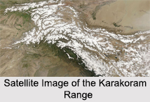
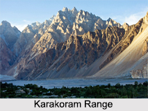
 The Karakoram Range spans from the borders of Pakistan, India and China. The Gilgit-Baltistan region of Pakistan, Ladakh region of India, and the Xinjiang Province of China are home to this mountain range. The range is about 500 km in length and is the most heavily glaciated part of the world outside the Polar Regions.
Etymology of Karakoram Range
The word Karakoram is derived from a Turkic term meaning black gravel. Early European travellers started using the term for the range of mountains, which was also known as Muztagh or the Ice Mountain. The later terminology of the mountain range was influenced by the Survey of India in the 1850s, when they gave the labels K1 to K6. K stands for Karakoram and the labels were given to the 6 high mountains visible from Mount Haramukh in Kashmir. In the ancient Sanskrit texts, called the Puranas, the name Krishnagiri or the black mountains were used to describe the range.
Formation of Karakoram Range
About 150 million years ago the Karakoram Mountain Range lay flat upon the bed of a vast inland sea known as the Tethys. The formation of this great mountain chain began when India drifted away from the supercontinent of Gondwanaland, which was a part of Pangea in the southern hemisphere. Slowly the Indian Continental Plate moved north, thus forming the great mountain range of Asia, including the Himalayas, Hindu Kush and Pamir.
Geology of Karakoram Range
The Karakoram Mountains are the most condensed cluster of high peaks and is considered to be one of the world"s most geologically active areas. It consists of a group of parallel ranges with several spurs and only the central part is a monolithic range. Standing at an average elevation of 20,000 feet, the topography of the range is characterized by jagged peaks and steep slopes.
Glaciers of Karakoram Range
Compared to the Himalayas and the Alps, a significant part of the Karakoram is glaciated. But in recent years due to climate change and emission of harmful gasses from the neighbouring industries, the ice has considerably melted away into the rivers and changed the precipitation pattern. The main valley glacier that was once 430 miles has been reduced to only 47 miles, a further indication of the severe climate change.
List of Highest Peaks in Karakoram Range
Karakoram has a long list of peaks, out of which 4 of them exceed 28,000 feet. Listed below are a few of those highest peaks in the range:
K2: Also commonly known as Mount Godwin Austen, it is the world"s 2nd highest mountain peak after Mount Everest. K2 stands at an elevation of 28,251 feet in the northwest of the Karakoram Range. Being heavily glaciated, it is tough to climb the mountain and causes a high number of fatalities. Since K2 lacked a local name, Mount Godwin Austen was suggested in honour of Henry Godwin-Austen, who was an early explorer of the area.
Gasherbrum I: Known to be the second highest peak in the Karakoram Range, Gasherbrum I is also commonly called K5 or the Hidden Peak. The mountain measures about 26, 510 feet above sea level, K5 lies between Pakistan"s Gilgit-Baltistan and Chinese Xinjiang border. It is part of the Gasherbrum group of 5 peaks located at the northeast end of Baltoro glacier. Gasherbrum has less than 200 ascents to date and with the least number of deaths since only the experienced climbers explore it.
Broad Peak: Standing at an elevation of 26,401 feet, Broad Peak is the 12th highest mountain in the world. It is a part of the Gasherbrum massif in Baltistan on the border of Pakistan and China. The first ascent of the peak was in 1957. On 2016, Frenchman Antoine Girard`s paraglider flight flew over the summit, which was the first time a paraglider had flown above the peak.
Gasherbrum II: With an elevation of 26,362 feet, it is the third highest member of the Gasherbrum group. It is located at the top of the Baltoro Glacier. The first ascent was in the year 1956 and on 2011 Gasherbrum was ascended for the first time in winter.
The majority of the highest peaks are in the Gilgit–Baltistan region of Pakistan. Baltistan has more than 100 mountain peaks exceeding 20,000 feet above the sea level.
 Sub-Ranges of Karakoram Range
Listed below are the names of few of the sub-ranges in the Karakoram Range:
Batura Muztagh: They are the westernmost sub-range of the Karakoram running from Chalt village in Bar Valley in the east to Kampir Dior in the Kurumbar Valley in the west, and they separate the Hindu Raj Range from the Karakoram Range. The Muchu Chhish peak located in this sub-range remains the scond highest unclimbed peak in the world.
Baltoro Muztagh: The crest of the Baltoro Muztagh range forms part of the Pakistan-China border disputed by India. The range is located in the Baltistan region of the Gilgit-Baltistan and in Xinjiang, China.
Siachen Muztagh: It is a remote sub-range of the eastern Karakoram Range. China controls almost 60 % of the area, while the rest 40 % is controlled by India. Pakistan claims the Indian controlled portion as part of the Siachen Conflict. The highest peak at this range is the Teram Kangri I, which stands at an elevation of 24,482 feet.
Saser Muztagh: It is the easternmost sub-range in the Karakoram range and is located in the Ladakh region of India. Since this region is near the disputed border between China and India, there is currently little climbing and exploratory activity in the range, except for occasional forays by the Indian military.
Other sub-ranges in the Karakoram mountain chains include the Hispar Muztagh, Masherbrum Mountains, Panmah Muztagh, etc.
List of Passes in Karakoram Range
Listed below are the seven passes of the Karakoram Range:
Mintika Pass: Also known as Mingteke Pass, it is located between Pakistan and Xinjiang. The name Mintaka means "a thousand goats" in Kyrgyz.
Kilk Pass: It lies 30 km to the west of Mintaka Pass and is a high mountain pass in the Karakorum Range. The two passes were, in ancient times, the two main access points into the Upper Hunza Valley from the north. In addition, the two passes were also the paths used to reach Chalachigu Valley and Taghdumbash Pamir from the south.
Khunjerab Pass: It is the highest paved international border crossing at 15,397 feet and is the only motorable pass across the range.
Shimshal Pass: Standing at an altitude of 15,534 feet, the Shimshal Pass lies on the watershed between the Indus River and the Tarim River basins. This pass does not cross an international border and is the only pass still in regular use.
Mustagh Pass: There are actually two passes, the eastern or `Old` Mustagh Pass and the `New` Mustagh Pass, about 16 km to the west. The pass is on the watershed between the rivers which flow towards the Tarim basin and those flowing to the Indian Ocean.
Karakoram Pass: It lies between India and China in the Karakoram Range. It is the highest pass on the ancient caravan route between Leh in Ladakh and Yarkand in the Tarim Basin. The high altitude of the pass and the lack of fodder were responsible for the deaths of countless pack animals.
Sasser Pass: It leads from the head of the Nubra Valley in Ladakh into the upper Shyok Valley in Pakistan. And then moves on to the even higher, but easier, Karakoram Pass.
The Karakoram Mountain Range is an arid region with an inhospitable environment and is not ideal for tourism. Expeditions are held where trekkers and hikers try to ascend this mountain range and witness the majestic Karakoram Mountain Range at its true form.


