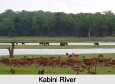
 The Kabini River is located in two southern states of India. More specifically, this river is situated in Kerala and Karnataka. It is also known by the other name of Kapila.
Geography of Kabini River
Globally, the Kabini River can be pinpointed at coordinates 12 degrees 7 minutes 21 seconds north and 76 degrees 41 minutes 38 seconds east. Nanjangud Town, Bannur and Chamarajanagar are the nearby cities of Kabini River.
Course of Kabini River
The Kabini River has its source and mouth in different locations. This river has its source in the Pakramthalam hills in Kuttyadi- Mananthavady road in the district of Wayanad in Kerala. The Makkiyad River and the Periya River amalgamate with the Kabini. The former river meets Kabini near Korome, while the latter joins the Kabini near Valad. The Panamaram River meets the Kabini near Payyampally, after flowing through Mananthavady town. One branch of the Panamaram River starts from the Banasura Sagar Reservoir near Padinjarethara, while the other branch of the river starts from Lakkidi hills. The Kabini then journey"s about 2 kilometers (1.2 mi) and forms an island called the Kuruva Island. While passing by the town of H D Kote, this river forms the mighty Kabini Reservoir. Between the Kuruva Island and the Kabini Reservoir, the Kalindi River, which has its source in the Brahmagiri Hills meets the Kabini. Apart from the above mentioned rivers, two small rivers namely, Taraka and Nugu in Heggadadevana Kote Taluk, also becomes a part of the Kabini River. As a part of its course, the Kabini runs towards east to join the Kaveri River at Tirumakudal Narasipur in Karnataka. Tirumakudal Narsipur in the Mysore district of Karnataka is known to be the mouth of Kabini River. The Kabini ultimately journeys towards the Bay of Bengal to amalgamate with it.
Places of Interest in and around Kabini River
River Kabini forms three noteworthy geographical features. One is a reservoir, while the others are a cluster of islands and a forest reserve. The reservoir is called the Kabini Reservoir, the group of islands is known by the name of Kuruva Islands and the forest reserve is called the Kabini Forest Reserve.
Kabini Reservoir
The Kabini Reservoir is situated across River Kabini near Bidarahally and Beechana halli in Heggadadevanakote Taluk, Mysore District, with canals on both the banks. The Gross Storage Capacity (MCM) of the Kabini Reservoir is 552.63. Its Live Storage Capacity (MCM) is about 443.63 and the Dead Storage Capacity (MCM) is about 99.675. Its Submergence Area (Th.Ha.) is about 6.403 and the Catchment Area (Sq.Km.) is about 2142. This Reservoir reaches full Level (m) at 696.16. The Maximum Water Level (m) in the reservoir is about 696.16 while its minimum Draw Down Level (m) is 690.68. The Basin of the Kabini Reservoir is Cauvery. The backwater of the Kabini reservoir is very rich in wildlife especially in summer. This is the time when the water level recedes to form rich grassy meadows. The Banasura Sagar Dam is located upon a tributary of the Kabini River.
Kuruva Islands of Kabini River
Also called Kuruva Dweep, the Kuruva Islands are defined as a protected river delta. They are located in the middle of the Kabini River in Wayanad. This cluster of islands consists of three densely wooded islands and a few submergible satellite islands. They are characterized as virgin and uninhabited. Around 950 acres has been estimated as the spread of this cluster of island. This cluster is a home to rare species of birds and butterflies and is therefore regarded as an ideal place for bird watchers.
Kabini Forest Reserve
The Kabini Forest Reserve is located on the banks of the Kabini River. More specifically, this reserve is located about 80 km (50 mi) from Mysuru and about 205 km (127 mi) from Bengaluru. It forms the south-eastern part of Nagarhole National Park. This reserve is spread over 55 acres (22 ha) of forestland, steep valleys and water bodies. This reserve is popular for its wildlife and bird life and is considered to be one of the best wildlife sanctuaries in Karnataka. Some of the wildlife of this reserve comprises elephants and tigers. This reserve is characterized by lush green landscape surrounding a large lake. It is accessible to tourists who can indulge themselves in sightings of herds of elephants and tigers. Kabini also once boasted of being a popular shikar hotspot of the British Viceroys and Indian royalty.
Other Reasons to Visit Kabini River
Since Kabini River has places of interest in and around it, the Kabini River bank can be called a tourism product. Apart from tourism, this river is also known for procession on boats.
Tourism of Kabini River
Apart from places of interest this river is frequented by tourists for the purpose of camping. Apart from camping, trekking is also an option for the visitors. From this place one can trek to the nearby Tadiyadamol or Kumara Parvatha. The bank of the Kabini River also has two noteworthy jungle resorts. The Cicada and the Kabini River lodge are available to people visiting this place and are also considered to be luxurious.
Procession on Boats on Kabini River
The Kabini River is known for the procession on boats also called teppootsava. It is the Uttsava Murthy (Procession Idol) of Lord Srikanteshwara which is taken for procession on the boat.
Related Articles:
Water Resources in India
Indian Rivers
Himalayan Rivers
Coastal Rivers
Deccan Rivers
Lakes of India


