 Kanyakumari district is surrounded by Majestic Hills and the plains bordered by colourful sea-shores, fringed with coconut trees and paddy fields. There are a few elevated patches of red cliffs with undulating valleys and plains between the mountainous terrain and the sea-coast, so closely interwoven with temples and churches and other edifices. The name of this district is spelled as `Kanniyakumari` in official record which is in tune with the spoken name of the district in the Tamil Language. With an area of one thousand six hundred and seventy two square kilometers, this district occupies 1.29 percent of the total extent of Tamil Nadu state. It ranks first in literacy among other districts in the state of Tamil Nadu.
Location of Kanyakumari District
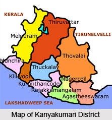
The district of Kanyakumari is the southern most districts in the state of Tamil Nadu. It is situated in between seventy seven degree fifteen minutes and seventy seven degree thirty six minutes to the East Longitudes and eight degree three minutes and eight degree thirty five minutes to the North Longitudes. The District is having its borders with Tirunelveli district, the Gulf of Mannar, the Indian Ocean, the Arabian Sea and the state of Kerala.
History of Kanyakumari District
The area covered by the present district of Kanyakumari was a part of the previous Travancore state. In the year 1835, when the Travancore state was divided into Northern and Southern divisions, this area formed part of the Southern division and was placed in charge of Dewan Peishkar, Kottayam. In the month of July 1949, when the United States of Cochin and Travancore was inaugurated, the present Kanyakumari area continued to form a part of Trivandrum district in Kerala. The people of Agasteeswarem, Thovalai, Kalkulam and Vilavancode taluks, which formed the southern divisions of the former Trivandrum district, were predominantly Tamil speaking. They agitated for the merger of this area with state of Madras. The States Reorganization Commission recommended this and the States Reorganization Act, 1956 was passed and the district of Kanyakumari was formed on the 1st of November 1956, with the four taluks, Viz., Kalkulam, Agasteeswarem, Thovalai and Vilavancode and merged with the state of Tamil Nadu.
Geography of Kanyakumari District
The district`s geographical condition is favourable with an agro-climatic condition. It is the southernmost district of the state of Tamil Nadu and is bound by the Tirunelveli district to the East and North, the Gulf of Mannar to the South-East, the Indian Ocean and the Arabian Sea to the South and the South-West and Kerala to the West and North-West. The district`s climatic condition facilitates the cultivation of several crops. The proximity of equator, its topography and other climatic factors favour the growth of various crops. Based on the agro-climatic and topographic conditions, the district can be divided into three regions; the uplands, the low lands and the middle. Forests in Kanyakumari district is verdant and virgin forests and said to be of seventy five million years old. Of the total district area of 167130 hectares, Government forests occupy an area of 50486 hectares which comes to about 30.2 percent of the total geographical area of the district. Unlike other districts in Tamil Nadu, Kanyakumari receives good rainfall from both North-East and South-West monsoons. The period of South West Monsoon is from June to September and North-East Monsoon is from October to December. Rivers in this district provide an important source of irrigation which includes Thamiraparani, Valliar, Paraliyar, Pazhayar and Ponniavaikal.
Administration of Kanyakumari District
The district is divided into two revenue divisions; Nagercoil and Padmanabhapuram. Each division is having a revenue divisional officer as its head. The Nagercoil revenue division consists of two taluks; one of the taluks is Agasteeswaram with its headquarters at Nagercoil and another is Thovalai with its headquarters at Boothapandi.  The Padmanabhapuram revenue division comprises of two taluks; Kalkulam with its headquarters at Thuckalay and Vilavancode with its headquarters at Kuzhithurai. These taluks are administered by the Tahsildars.
Culture of Kanyakumari District
The people of Kanyakumari form the human resource of the district. Their religion, culture, beliefs, aptitude, habits, talents etc have a bearing on the way the district presents itself to others. Malayalam and Tamil are the main languages of this district. Hindus and Christians form a major percentage of the population of the district of Kanyakumari and there are several Muslims dominated belts also in the district. The caste system in the society has weakened to a great extent largely after independence because of growth of education and improvements in communication and transport. Some of the communities living in this district are Nadars, Nanjil Nadu Vellalars, Mukthavas, Vilakki Thalanayar, Paravas, Kammalar or Asari, Chackarevars, Kerala Mudalis, Nairs, etc.
Education in Kanyakumari District
The Christian Missionaries, as in other parts of India, were the pioneers of English education in the erstwhile Travancore State and mainly in the then South-Travancore, the area that presently forms the district of Kanyakumari. The Dutch and Portuguese, who came to the erstwhile Travancore State even before the British, were the Roman Catholics and they did little to improve education.  But, the Protestant Missionaries who arrived later were the first to introduce English Education in Kanyakumari, which formed a part and parcel of the then Travancore State.
Tourism of Kanyakumari District
The district attracts a large number of tourists from different parts of India throughout the year. The Kanyakumari district is famous for its majestic hills, pristine rivers, virgin beaches and meandering rivulets. It has a fragrance of architecture, culture and customs of neighbouring Kerala mixed with the rich deep traditions, culture and architecture of Tamil Nadu as well. Tourists often come and go by seeing Kanyakumari and the Padmanabhapuram Palace as well as various other attractions.
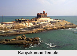
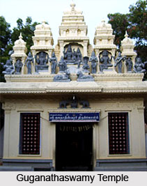
Some of the major tourist attractions in the district of Kanyakumari include Fountain at Kanniyakumari, Thiruvalluvar Statue, Mahatma Gandhi Memorial, Kamarajar Manimandapam, Vivekananda Mandapam, Vivekananda Rock Memorial, Shripada Mandapam, View Tower and Telescope House, Guganathaswamy Temple, Government Museum, Suchindrum , Kanyakumari Bagavathiamman Temple, Mathoor Hanging Bridge, Udayagiri Fort, Padmanabhapuram Palace, St. Xavier Church, Pechiparai Reservoir, Tirparappu Water Falls, Peer Mohammed Durha, Maruthuva Malai, Muttom Beach, Sanguthurai Beach, Chothavilai Beach, etc.


