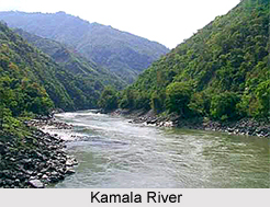
 The Kamala River is located in the Indian state of Bihar. More specifically, this river flows through Nepal and Bihar. It is important to note that this river has its source and mouth located in different countries. Its source is located near Maithan, Sindhuliagarhi, Sindhuli District, Churia Range in Nepal. In India, it"s mouth is located in Badlaghat, darbhanga, (jaideopatty,thangha) Khagaria district in Bihar. Kamala River is one of the most important rivers of Bihar. It is known as Kamala Nadi in Hindi as well as Nepali. Characteristically, this river is a snow fed river.
Geography of Kamala River
Globally, the source and mouth of Kamala River can be pinpointed at two distinct coordinates. Its source can be pinpointed at 27degrees 15minutes North and 85degrees 57 minutes East. Its mouth can be pinpointed at 25degrees 33 minutes 54seconds North and 86degrees 35minutes 06 seconds East. It is located at an elevation of about 1,200 m (3,937 ft), in Nepal. Its total length is about 328 km (204 mi), out of which 208 kilometres (129 mi) is in Nepal and the remaining 120 kilometres (75 mi) is in India. The total catchment area drained by this river is about 7,232 square kilometres (2,792 sq mi) out of which 2,744 square kilometres (1,059 sq mi) lies in Nepal and 4,488 square kilometres (1,733 sq mi) is in Bihar. Average annual rainfall received by this river is about 1,260 millimetres (50 in). Its curtailed area in Bihar is about 2,744 square kilometres (1,059 sq mi). The Kamala basin in Bihar has a population of about 3.9 million. Tao River and Baijnath Khola River merges with Kamala at Maini.
Course of Kamala River
As far as the course of Kamala River is concerned, it is important to note that it commences from Nepal and reaches it"s destination in India. Crossing Kamala Khoj area, this river flows in a southerly direction. It then continues its journey in the terai area of Nepal at Chisapani, after passing through a gorge above Chauphat. In terai, it acts as a border between Siraha and Dhanusa districts. During the monsoons, this river is known to trigger ruinous river bank erosion as a result of its expansion.
It enters India in Madhubani district in Bihar, which is 3.5 kilometres (2.2 mi) upstream of Jainagar. In the vicinity of Jainagar, a barrage known as Kamala barrage has been constructed by the State Government. Along its journey, the Kamala then joins the river Kareh (Bagmati) at Badlaghat in Khagaria district and the combined stream flows into the nearby Koshi. When the Kamala branches out, one of it heads towards Bagmati while another heads towards Kosi. In the lower reaches, the Kamala follows the course of Balan. For this reason this river is also known as Kamala Balan.
Tributaries of Kamala River
Since the Kamala River branches out, it forms tributaries. The main tributaries of Kamala River are the Chadaha, Tao, Dhauri, Mainawati, Balan, Baijnath Khola, Trisula and Soni.
Development of Kamala River
On the Kamala River, there is the Kamala Multipurpose Project that would involve the construction of storage dam in the districts of Dhanusa and Siraha in Nepal. The project would provide year round irrigation facilities and generate hydropower with an installed capacity of 30 Mega Watt. This scheme forms part of the Sunkosi Storage-cum-Diversion Scheme, which involves diverting water from the Sunkosi River to the Kamala River to augment lean season flow.
It is important to note that northern part of Bihar is an earthquake prone area. In 1998, the earthquake zone was Darbhanga District that is only 60 kilometers (37 mi) from the borders of Nepal. In1988, Kamala River embankment in Madhubani district breached due to earthquake cracks, as it is an earthquake prone zone.
Related Articles:
Indian Rivers
Ganga River
Gandak, Indian River
Mahananda River
Karmanasa River
Son River
Phalgu River
Kamala River


