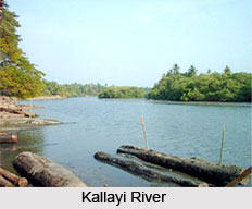
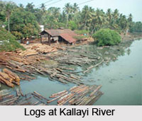
 Kallayi River is a river flowing in the southern state of India, Kerala. Kallayi River is one of the smallest rivers in the State. The river rises in the Western Ghats of Cherikkulathur village in Kozhikode District at a height of 45m. It is linked to the Chaliyar River by an artificial canal on the south side of the small timber village of Kallayi, which is situated on the bank of the river. The river flows through Cherikkulathur, Kovur, Olavanna, Mankavu, Kallayi, Pallikkandi and Kothi and ultimately evacuates in the Arabian Sea at Kozhikode. The river basin is located in the Kozhikode district. The river is 22km in length and is spread over an area of 96 sqkm. The river is commercially very significant. The basin is considered as the ancient place of international trade and was used for inland water transport.
In the past, the river was the second largest centre of timber business in the world. The Cannoly Canal in the north and Beypore-Kallayi Canal in the south are linked to the Kallayi River. The Cannoly canal which has a length of 11.5 km connects Kallayi River and Elathur River. This canal was earlier used for bringing timber from Beypore and Nilambur and for inland navigation.
Pollution at Kallayi River
As the timber industry faded and sawmills shut down, the land along the river banks were encroached. The legendary Kallayi River that symbolized the civilization of Kozhikode is dying a slow death. The filth accumulated over the years has ruined the serene eco-system of the river. The natural flow of water has also slowed down on account of silting. The acute pollution has decimated aquatic life in the river. Mangrove vegetation on the riverbanks had also been destroyed in many places.
Waste disposed from butcheries in the area and household garbage is dumped into the river. Infestation of weeds, discharge of untreated effluent into the river, dumping of hospital waste, unprotected embankment and untreated waste from septic tanks are hastening its degeneration. The depositing of solid waste from construction sites had led to slow filling of the river. Further, the dumping of animal slaughterhouse waste indiscriminately into the river had decreased the depth and area of the river.
A project for restoration of the health of the river and eco-restoration should begin with surveys and investigations to find out the extent of encroachment, mapping of existing mangrove growth and the social life on the river`s banks.
 Kallayi Town
Kallayi is a small town on the banks of Kallayi River which links with the Chaliyar River on the south by a man-made canal. It is in the Kozhikode district of Kerala in south India and is noted for timber trading during the late 19th and early 20th centuries.
During that period, the Chaliyar River was extensively used as a waterway for carrying timber from the forest areas in and around Nilambur to the various mills in Kallayi near Kozhikode. Rafts made of logs were taken downstream during the monsoon season to Kallayi, where these were sawn to size in the timber mills here and then transported for trade.
During this period, Kallayi was one of the most important centers in the world for the timber business. The place was noted for woods of superlative strength and durability like teak, rosewood etc. Towards the second half of the 20th century, the activity declined drastically as tree felling was banned or strictly controlled with a view to stop deforestation. Many have now closed down. Today, only a few timber mills exist in the area and one can spot a few logs from these timber yards floating on the Kallayi River.
Growth of Timber Industry at Kallayi River Banks
The river once supported the growth of timber markets and sawmills in the region. As the saline water of the river provided extra strength to the timber, logs from different regions of the State were left to season in Kallayi for several weeks or even months together. Hence, numerous timber mills dotted the banks and massive cranes lifting the logs were a familiar spectacle. Being the most prominent navigable waterway during the reign of Zamorins, Kallayi was mainly used for transporting timber, hill produces and spices from Nilambur forest to the commercial port of Kozhikode.
Scenic Beauty of Kallayi River
Another interesting sight here is the iron Kallayi Bridge. It is an iron bridge built by the British across the river is a prime attraction. Vast stretches of mangroves flank the banks of the river which add to its visual splendour. Flocks of birds, migratory and indigenous, resting in the mangroves and on the floating timber are a common sight in Kallayi.
Kallayi was considered the perfect location to shoot the romantic film sequences. Rafts and country boats used for transporting goods through the river and the traditional fishing boats are a common sight in some areas along the river. The view from the bridge of the surrounding areas is delightful. The view of sunset seen from the bridge is simply breathtaking.


