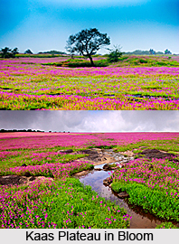
 Kaas Plateau is nestled in the Western Ghat Sahyadri range in the Indian state Maharashtra. Also known as Kaas Pathar, the place derives its name from Kaasa tree, scientifically known as Elaeocarpus glandulosus. With maturation, the leaves of this tree change its colour from green to red. In the month of March, white flowers bloom for only 15 days. The region spans over an area of about 1000 hectare. During the months of August and September Kaas Plateau takes up an amazing visage and swathes with wild blooms of vibrant shades. The United Nations Educational Scientific and Cultural Organization (UNESCO) has declared the place as Biodiversity World Heritage Site. Kaas Plateau is a picturesque weekend gateway and is adored by nature enthusiasts.
Geography of Kaas Plateau
Kaas Plateau is a high hill plateau and with the onset of monsoon season, the grassland springs to life and changes into a land of flowers. The major portion of Kaas Plateau has been declared as a reserve forest. The plateau is mainly composed of basalt, exposed directly to atmosphere. A thin layer of soil covers the basalt rocks which formed owing to the erosion and accumulated as a layer of about an inch over the rocks. The soil is neither lateritic nor black. Certain areas of the plateau also accumulate water because of uneven surface.
 Biodiversity of Kaas Plateau
Kaas Plateau has a rich biodiversity. Over 850 varied species of flowers grow in Kaas plateau including Karvy, Orchids, Drosera Indica and many more. Out of them, 624 species have been included in the Red Data Book. Among these 624 types, 39 are found only in this region. Various shrubs and grasses are also found here. During monsoon season, the orchids blossom for a period of 3 to 4 weeks. Many of the plant species found in Kaas Plateau are quite rare and new to the botanical science. Many endemic and endangered species also grow here. In the breathtaking carpet of wild flowers, prominent ones found are Exacum tetragonum, Arisaema murrayi, Oberonia recurva, Vigna vexillata, Dioscorea bulbifera, Linum mysurense, Rotala fimbriata, Habenaria grandifloriformis and many more.
Other Attractions of Kaas Plateau
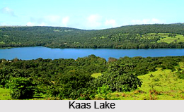
Kaas Lake is located between Sajjangad fort and the Kanher Dam and is enclosed by thick forest. It lies towards the south of Kaas Plateau. The lake resembles a bowl carved out of the Sahyadri Mountains. It serves as a perennial source of water supply for the western region of Satara city. Koyna project is 30 kilometres away, towards the south of Kaas Lake. Apart from the lake there are several other picturesque attractions near Kaas Plateau. Temples, boating places, picnic spots and caves can also be enjoyed by the tourists. Kaas Plateau serves as a hub of scenic charms. Vajrai Waterfall, India"s highest waterfall, is also located nearby.
Visiting Information
Kaas Plateau is located at a distance of 22 kilometres from Satara city and can be reached either from Satara or from Tapola via Mahabaleshwar and Panchgani. It is 125 kilometres away from Pune, 280 kilometres from Mumbai and 150 kilometres from Kolhapur. It is a paradise for nature lovers and nature photographers. People from all across globe visit Kaas Plateau during monsoon to witness its mesmerizing visage and vibrant hues.


