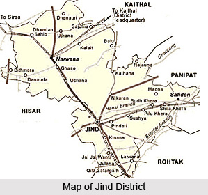
 Jind District is one of the 21 administrative districts of Haryana. Jind town is the district headquarters. It is one of the oldest districts of Haryana and is one of the first Sikh Kingdoms. It lies in central region Haryana and is the fourth district of the Jat belt (includes Sonipat, Rohtak, Hisar and Jind). Jind town has Arjun stadium, milk plant, cattle feed plant and a large grain market. The town is well provided with schools, colleges, hospitals and other basic amenities. Other smaller towns of Jind District are Narwana, Safidon and Uchana. The total area of Jind district is 3606 sq kms and its total population as per 2001 Census is 11, 90,000.
Location of Jind District
Jind District lies between 29 degree 3 minutes and 29 degree 51 minutes north latitude and 75 degree 53 minutes and 76 degree 47 minutes east longitude. On its east and north-east lie the districts of Panipat, Karnal and Kaithal respectively. Its boundary line on the north forms the interstate Haryana- Punjab border with Patiala District and Sangrur district of Punjab. In its west and south-west it has a common boundary with district Hisar and Fatehabad and in its south and south-east it is surrounded by the districts of Rohtak and Sonipat respectively.
History of Jind District
Jind District derives its name from its headquarters town Jind that is said to be a distortion of Jaintapuri.
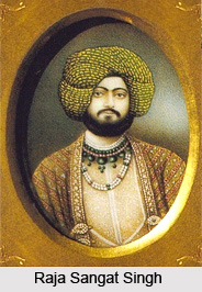
 It is also said that this town had been founded at the time of Mahabharata. According to an old saying the Pandavas built a temple in honour of Jainti Devi (the goddess of victory), offered prayers for success, and then launched the battle with the Kauravas. The town grew up around the temple and was named Jaintapuri (Abode of Jainti Devi) which later on came to be known as Jind. According to the legend, the Pandavas built here a temple in honour of Jainti Devi (the goddess of victory) and offered prayers for success in their battle against the Kauravas. The town grew up around the temple and was named Jaintapuri, (abode of Jainti Devi) which in course of time came to be known as Jind. Raja Gajpat Singh in 1755 seized a large tract of country including the present districts of Jind from Afghan invaders and made Jind the capital of the state in 1776. He made a fort here in 1775. Later, Sangrur was chosen as capital of Jind State by Raja Sangat Singh (1822 to 1834 AD).
Geography of Jind District
Geography of Jind District includes vast plain lands and sand ridges. The largest and the highest sand dune of the district lying north-west of Kakrod village (Narwana tehsil) is 2 kms long and quarter a kilometer wide and has a local relief of 6 meters. Other areas where sand dunes occur frequently are the area along Hisar border between Sulhera village in the north and Danauda Khurd village in the south where the local relief ranges between 2 to 5 meters; the area in the vicinity of village Ashrafgarh, especially south-west and south of the village where the sand dunes rise from 2 to 4 meters above the local relief, the small area lying to south of Julani village (west of Jind town); and the area in the proximity of Jai Jai Wanti village in Jind tehsil which has wide undulations but where the local relief variations do not exceed 4 meters. Apart from these sand ridges there are certain depressions too at some places. Topographically this district is flat alluvial upland plain, which is dotted in some places with sand dunes and depressions.
Administration of Jind District
Administration of Jind District comprises three sub-divisions namely Jind, Narwana and Safidon. Jind sub-division is further divided into two tehsils - Jind and Julana. Narwana and Safidon sub-divisions comprise only one tehsil each, Narwana and Safidon respectively. Further, there are five Vidhan Sabha constituencies in this district - Julana, Safidon, Jind, Uchana Kalan and Narwana.
Education in Jind District
Before the middle of the 19th century only the indigenous system of education existed in the Jind District. No serious efforts were made by the princely state authorities till the close of 19th century when a few upper primary and vernacular middle schools were opened at Jind, Safidon and Narwana. These schools were later remodelled on Punjab educational system. There are several primary schools, secondary schools and degree colleges in Jind District.

Tourism in Jind District
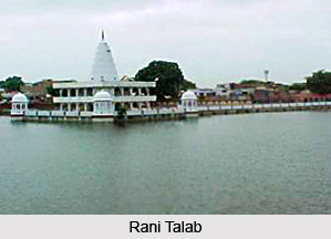
Rani Talab is the major tourist attraction of Jind District. There are several devotional places here attracting a large number of devotees. Munjavata Tirtha, Varaha Tirtha, Asvini Kumara Tirtha, Pushkara Tirtha, Ekahamsa Tirtha, Jind, Bhuteshvara temple, Dhamtan Sahib and Ramrai are some of the prominent places of Jind District. These places are worth visiting.
Jind Town is situated on the Ferozepur-Delhi section of the Northern Railway, around 123 kms away from Delhi and 57 Kilometers from Rohtak. It is also connected by road with Delhi, Patiala, Chandigarh and other important towns of Haryana.


