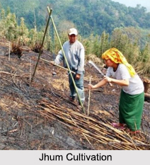
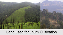
 Jhum Cultivation, commonly known as "Shifting Cultivation" is still prevalent among the indigenous communities of North East India. This farming system has been widely disputed as environmentally destructive. Jhum Cultivation in North East India has been part and parcel of the region"s tradition and culture since time immemorial and its practice is widespread even to this day.
History of Jhum Cultivation
Jhum Cultivation as a system of agriculture represents an indigenous form from time immemorial. Man learnt about the art of crop growing around 6000-5000BC. As the pressure of population increased, the hunters-cum-cultivators of the Neolithic period started clearing more patches in forests to bring them under cultivation. As fertility decreased, they used to migrate to new tracts to burn and clear forests for sowing crops. This type of cultivation has been termed as "slash and burn" or "Shifting Cultivation".
Etymology of Jhum Cultivation
Jhum Cultivation is known by different names in various parts of the world. The term "Jhum" is most frequently used in North Eastern region. In other parts of India, it is known by various names such as: "Bewar", "Dahiya", "Panda" in Madhya Pradesh, "Roma", "Dahi", "Raman", "Bringa", "Gidiya" in Odisha and "Padue" in Andhra Pradesh.
Process of Jhum Cultivation
The process of Jhum cultivation usually starts with the selection of a slope on the hillside. The village headman does it generally during December and January. The senior members of the village may help him. In taking a decision, the village elders review their past experience and consider various alternatives. These decisions are usually preceded by numerous rituals such as worship of deities, appeasing evil spirits, sacrifices, feasts and dances. After this, on an auspicious day the villagers start cleaning the land by cutting the trees and shrubs. When the traces have dried up they are set on fire (usually in April). Subsequently the ashes are scattered over the ground and the land is ready for allotment to individual families. Preferences are given to the widows, in-firms, weak and old people who are generally allotted the central part of the Jhum field. The amount of land allotted depends upon the size and the workforce of the family. Usually the male members of the family prepare the land and seeds are sown either by broadcast or by dibbling. The dibbling of seeds is the exclusive job of females whereas, broadcast of rice, oilseeds, millets and cotton are done by males. The harvesting formally starts after elaborate rituals including sacrifices and feasts. The main crops of maize, rice, millets, pulses and oilseeds are harvested in September and October.
 Consequences of Jhum Cultivation
The pressure of population in the Jhum land is increasing day by day in the entire North East India. As a result, people have to come back to the same plot of land within a short period. Owing to this shorter cycle of Jhumming, the forest does not achieve maturity and it disappears speedily. It also changes the social and economic structure and leads to commercialisation of shifting cultivation. The intensive use of the highly fragile and vulnerable eco-systems results in soil erosion and land depletion under the torrential rains of monsoons. In such circumstances, Jhum cultivation has been criticised on ecological and socio-economic grounds. Large scale burning of forests, destruction of natural habitats, and the consequent reduction of fauna and flora are some conspicuous results of Jhum cultivation. According to ecologists and environmentalists, Jhum cultivation is economically unviable and ecologically unsustainable. Its continuation damages the eco-systems converting lush green forests into ecological slums. In view of such alarming consequences, Jhum cultivation should be diversified and the people should pursue Terrace cultivation in the lower slopes of the hills. The higher slopes can be used for growing fuel-woods, orchards, fruit-trees, nut-trees, pineapples, etc. Otherwise the entire North East India will become an ecological slum in the near future.


