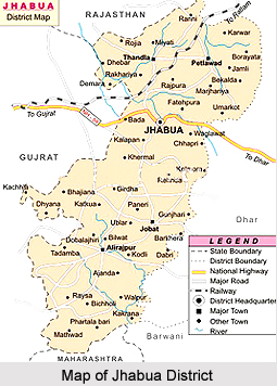
 Jhabua is a predominantly tribal district located in the western part of Madhya Pradesh. The total area is 6793 square kilometres. There are about 1313 inhabited villages. It can be said about Jhabua District that it is an overwhelmingly tribal and poor district.
Geography of Jhabua District
Jhabua is surrounded by Panchamahal and vadodara districts of Gujarat, Banswara district of Rajsthan and Dhar and Ratlam districts of Madhya Pradesh. Narmada River forms the southern boundary of the district. The terrain is hilly, undulating typically known as "Jhabua hills topography". In this Jhabua hill topography the difference between the highest and the lowest points varies between 20 to 50 meters. But this difference goes on increasing as one move towards south of Jhabua. In the Alirajpur division which is in the south of Jhabua the areas is almost a hilly and intersected by narrow valleys and low Vindhayas Mountain ranges covered with jungles. But most part of Jhabua is without any forest cover because of low fertility of land and soil erosion.
Climate is generally moderate and seasons are well defined. The summers are hot, winters are short and the monsoon season is generally pleasant. The average rainfall in the district is about 800mm. Most of the rainfall occurs in monsoon season while there is also a little of rainfall in winter season.
 Demography of Jhabua District
Jhabua is sparsely populated area with the total population of 13.94 lakhs according to 2001 census. About 85% of population is tribal while 3% population belongs to Schedule Castes. 47 per cent of the people live below the poverty line. The literacy rate according to 2001 census is 36.87% with female literacy of only 4%.
Culture of Jhabua District
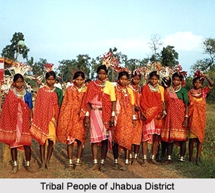
Jhabua District is inhabited by the tenacious and hardworking tribes - the Bhil Tribe and Bhilalas, the district is highly drought-prone and degraded waste lands form the face for Jhabua. Although almost half of the population lives below the poverty line, the tribals still revel in their traditional colourful festivities and continue to make merry on the occasions like "Bhagoriya". The women make lovely ethnic items including bamboo products, doll, bead-jewellery and other items that have for long decorated the living rooms all over the country. The men have since ages adorned "Teer-Kamthi", the bow and arrow, which has been their symbol of chivalry and self-defence.
Tourism of Jhabua District
The tribal land of Jhabua is quite prominent as a tourist place in the state of Madhya Pradesh. The tourist places of Jhabua have historical and natural interest. Some of them also are a treat for the eyes of an onlooker for its natural beauty. Some of the tourist destinations of Jhabua District are Bhabhara, Deojhiri, Lakhmani Gram, Malwai and Amkhut.


