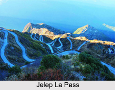
 The high mountain pass of Jelep La stands at an altitude of 4, 267 m between the East Sikkim District and Tibet Autonomous Region in China. The word Jelep La is of Tibetan origin and it means "the lovely level pass". It has truly the most horizontal plane among all the passes between Sikkim and Tibet. For centuries, the Jelep La Pass has been used by traders because of its less rugged terrain.
Overview of Jelep La Pass
On the Indian side, the Jelep La Pass has 2 routes: one runs through Kalimpong and the other through Gangtok. The Kalimpong route is the older one and it passes across the pristine towns of Pedong in Northern part of West Bengal, Rhenok and Kupup. Till early last century, the Kalimpong route has played a pivotal role in the upliftment of local economic condition, as it was used for trading furs and wool. However, the route has been closed down after the Sino-Indian War in 1962. The route from Gangtok passes through the town of Sherathang, which is nearby Changu Lake alongside Nathu La and through Kupup. The beautiful Menmecho Lake flows below the Jelep La Pass.
With numerous hamlets scattered around the surrounding area, the route to Jelep La Pass is quite scenic with forests of rhododendron, which are in full bloom during the spring season. On the Tibetan side the Jelep La Pass leads to the Chumbi Valley of the Tibetan Plateau.
History of Jelep La Pass
Since the ancient times, the Jelep La Pass has been a major trade route which has helped in flourishing the trade relation between India and Tibet. With the onset of the British colonialism, they built roads in Sikkim around 1884. In the year 1886, a small Tibetan armed force occupied the area around the pass and in May 1888, the British were attacked by the force but were warded off. However, late in the same year, in the month of September the British reoccupied the area around the pass.
With the rising influence of Russia in Tibet, the British sent an expedition in 1904, via Jelep La Pass to Lhasa. This expedition was confronted by formidable Tibetan forces. However, the British defeated them. In the absence of the 13th Dalai Lama, who had escaped to Mongolia, a trade agreement was forced on the Tibetans.
After the Indian independence, Sikkim became a monarchy and during this time, Sikkim was granted a special protectorate status and India owned the status of a suzerain nation. From that point onwards, the defence and foreign affairs of Sikkim are managed by India. After the invasion of Tibet by China in 1950, the passes in Sikkim were used by the refugees coming from Tibet. However, after the Sino-Indian War in 1962, the Jelep La Pass was closed down permanently.
In the early phase of 1975, following a referendum, Sikkim became a part of India. Currently, with the recent development in relation between India and China, there are possibilities in reopening the Jelep La Pass which will lead to an economic boom in the region.


