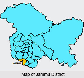
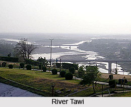
 Jammu District is one of the administrative districts of Jammu and Kashmir. Jammu District serves as the winter capital of the state from November to April when all the offices move from Srinagar to Jammu. It is known for its temples that attract the people from different parts of the country. Jammu District derives its name from the city of Jammu which besides being the winter capital of the state, is known as the city of temples. Jammu is situated on a hillock, on the bank of river Tawi. Jammu District has numerous religious shrines. Jammu also serves as base camp for the holy shrine of Vaishno Devi. Jammu is also the railhead of the state.
Location of Jammu District
Jammu is located 74 degree 24 minutes and 75 degree 18 minutes east longitude and 32 degree 50 minutes and 33 degree 30 minutes north latitude. It is approximately 600 kms away from New Delhi and is linked with a National Highway. Jammu District is bounded in the north and north east by the Tehsils of Reasi in Udhampur District in the east and south east partly by tehsil Ramnagar of Udhampur district and partly by tehsil Billawar of Kathua district, in the south and south west by Kathua district and Sialkote district of Rawalpindi (Pakistan) and in the north west by Tehsil Nowshara of Rajouri District and parts of the district Bhimber now under the occupation of Pakistan.
History of Jammu District
There are several legends that are associated with the origin of the name of the district. It is believed that the city of Jammu was originally founded by Raja Jamboo Lochan who lived in 14th century B.C. The Raja had gone out one day for hunting when he happened to witness a tiger and a goat drinking water from one and the same pond. This extraordinary phenomenon set him thinking and he decided to build a city at this site so that the strong and weak could live together in peace and mutual tolerance. Eventually, he founded the city which came to be known as `Jamboo` after his own name. With the passage of time and due to its frequent use the pronunciation of the name got slightly distorted and the city came to be known as `Jammu` as it is called now.
 Geography of Jammu District
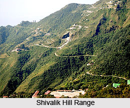
Jammu District falls in sub-mountainous region at the foothills of the Himalaya Mountains. Shivalik Hills rises gradually in the north part of the district and merges with the Indo Gangetic plain in the south. Jammu city is at an elevation of 1030 feet above the sea level. Jammu District has a sub tropical climate with hot and dry climate in summer and cold climate in winter. Being in the foothills of the mountains, nights are generally cooler than what they are in the neighbouring areas of Punjab. Minimum and maximum temperature is around 4 degree Celsius and 47 degree Celsius respectively. Rainy season usually starts from the end of June or the beginning of July. Average rainfall in the district is about 1246 mm.
Demography of Jammu District
As per the census of 2001, Jammu District has a population of 15.88 lakh. Scheduled caste population in the district is around 3.94 lakh, it accounts for around 24.81 percent of the total population. The average density of population in the district as per census of 2001 is 513 persons per square km. Jammu District is spread over an area of 3097 sq kms. The literacy percentage of the District is 77 percent as per 2001 census which was highest in the state.
 Administration of Jammu District
Administratively Jammu District has been divided into 5 tehsils, 11 blocks 13 towns including one municipality 1192 villages and 201 Panchayats including 41 command areas. The five tehsils are Jammu, Samba, R.S.Pura, Akhnoor and Bishnah. The entire district can be divided into two distinct portions. The area forming north of Jammu-Chhamb road and Jammu-Pathankot road which is known as Kandi area is comparatively under-developed and is mostly rain fed. The area south of these roads is largely fed by canal and tube wells for irrigation purposes and is relatively more prosperous. Out of the 11 development blocks, the administrative control of two blocks namely Vijaypur and Samba is with the directorate of Command Area Development who is charged with the responsibility of looking after the developmental activities in the sectors of Agriculture and Horticulture, Cooperation and Rural Development.
Tourism in Jammu District
Jammu District is famous for its temples. In fact Jammu is known as the city of temples and there are several palaces, forts and forests that are worth exploring. The other major tourist attraction is the Ragunath Temple Complex. Maharaja Gulab Singh began the construction of the Raghunath Mandir Complex in the crowded downtown Bazaar named after it, in the year 1851. It contains representations of entire Hindu pantheon, though the emphasis falls on the various incarnations of Lord Vishnu. The complex houses a rich collection of ancient texts and manuscripts. Bahu Temple is a renowned historical temple of Goddess Mahakali popularly known as Bawe-Wali Mata. The temple overlooks the river Tawi flowing placidly down the Jammu city. Dogra Art Museum is located in the erstwhile Pink Hall of the old Mubarak Mandi Palace Complex. This museum houses 800 rare and exquisite paintings from different schools of paintings. The museum also has Shahnama and Sikandernama hand written manuscripts in Persian.
Mubarak Mandi Complex is another popular tourist attraction of Jammu District and it has a history which is 150 years old. It was royal residence of Dogra Kings. The location was carefully selected for having a commanding view of river Tawi on one side and the city on other side. The palaces are built as a group of buildings around a courtyard. The complex has halls and galleries which were used for official functions and ceremonies. As the time passed the need was felt to have separate buildings to house full fledged Royal Secretariat. These buildings were constructed around a garden cum courtyard which ultimately became the venue for important events for Royal audience for common man. The city has a number of historic Idgahs. Of them Ziarat Baba Buddan Shah is located in the outskirts of Jammu city at a distance of about 8 kms towards the aerodrome at Satwari. This ziarat is very popular among all sections of society and is being visited by large number of people throughout the year. Other Idgahs are Ziarat Baba Roshan Shah Wali near Gumat Bazar, Ziarat Peer Mitha near Peer mitha bazar. Another Idgah is Panch-Peer. This Dargah is situated at a little distance from the Maharaja`s palace on the Jammu-Srinagar National Highway. The place is known because of the residence of five peers, who lived here and dedicated themselves to the meditation
Jammu District is aptly considered as a land of grand ancient temples, and beautiful palaces. Jammu District is having a National Airport situated at Satwari.


