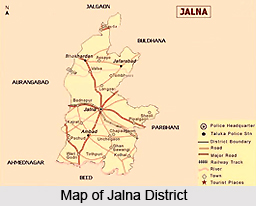
 Jalna district was formerly a part of the Nizam state. It became a part of India, as a tahsil of Aurangabad district, after the Marathwada Mukti Sangram. The district of Jalna, as distinct from Aurangabad, was formed on 1st May 1982 by carving out Jalna, Bhokardan, Jafrabad and Ambad tahsils from the Aurangabad district and Partur tahsil from the Parbhani district. The district headquarters is at Jalna and it is well connected to the state capital and national capital by broad gauge railway line. The major towns of the state are also connected by state highways. Jalna district is well-known for its hybrid seed processing industries, steel re-rolling mills, bidi industry and agro-based industries like dal mill. The district is also known for Jamb-Samarth, which is the birthplace of Sant Ramdas Swami, who was the Guru of Chatrapati Shivaji Maharaj. The district of Jalna covers an area of 7,612 Sq.Kms, which is 2.47 percent of the total area of the state.
Location of Jalna District
The district of Jalna is situated approximately in the centre of the state of Maharashtra and in the northern direction of the Marathwada region. It lies between the north latitudes of 19 degrees 1 minute and 21 degrees 3 minutes and the east longitudes of 75 degrees and 76.4 degrees. The district is bounded by Jalgaon district in the north, Parbhani and Buldhana in the east, Beed district in the south and Aurangabad district in the west. It covers an area of 7,612 Sq.Kms, which is 2.47 percent of the total state area.
Geography of Jalna District
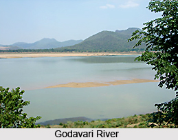
Jalna district has a moderate to gently sloping undulating topography. The major part of the district falls under the Godavari river basin, more specifically the Purna sub-basin which is a tributary of the Godavari River. The district has a sub-Tropical climate, in which the bulk of rainfall is received from the southwest monsoon, between June and September. The rainy season is followed by winter, which lasts up to February. Minimum temperatures hit 9 degrees Celsius during this time. The winter is followed by hot summer, which continues up to June. Temperatures during this time soar up to 43 degree Celsius.
Demography of Jalna District
 According to the last Census in 2001, Jalna district has a total population of 16,12,357 and the density of population is 209 persons per square Km. The population of males in the district is around 8,25,977 while females in the district make up 7,86,380 of the population. The male-female ratio in the district is 1000 / 952, i.e., 952 females per 100 males. Literacy rate in the district is 64.52 percent. The male literacy rate is 79.17 percent whereas the female literacy rate is 49.25 percent.
Administration of Jalna District
Jalna district came into existence on 1st May 1981 with five tahsils namely Jalna, Ambad, Bhokardan, Jafrabad, Partur and one Jalna subdivision. Jalna city was declared as the district headquarters. On 26th January 1992 one more Subdivision came in to existence at Partur, and on 15th August 1992 three new tahsils were reconstituted namely Mantha, Badnapur and Ghansavangi. So at present there are 2 Sub-divisions, 8 Tahsils and 970 Villages in Jalna district. The administration of Jalna district is headed by the District Collector. Collectorate is the backbone of district administration. All kinds of decisions, law and order, revenue, elections, dealing with natural calamities etc are some of the responsibilities of the Collectorate.
Economy of Jalna District
The economy of Jalna district is based on agriculture and agro-industries, as 85 percent of the geographical area is under agricultural use. Out of the total 7, 61,200 hectares of the geographical area, 6, 51,553 hectares of land is under agricultural use. About 75 percent of the agricultural area is under Kharif crops, and 40 percent of land is under Rabi crops. Among the major crops grown in the district are jowar, wheat and cotton. Around 15 percent of the area is double-cropped whereas only 7.8 percent of the area is irrigated which is far below the state average.


