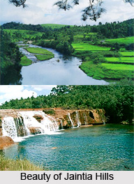
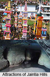
 Jaintia hills are situated in the Meghalaya state of India. The hills occupy an area of 3819 km sq. m. The Jaintia hills district is part of the Meghalaya subtropical forests region. Lush greenery, high plateaus, and bewildering valleys, rippling rivers are some of the attractions and sights of Jaintia hills. The beauty around the hills attracts tourist from all parts of the world.
History of Jaintia Hills
The Jaintia hills district was created in the year 1972. The people living in Jaintia hills district of Meghalaya are ethno linguistic group of people and are believed to be of Indo-Mongoloid race although speaking a distinct Austric language belonging to the Mon-Khmer group. With regard to the social origin of the Jaintia people there is an indigenous theory according to which they belonged to a common race which occupied a large area of Northern India, Burma, Indo-China and parts of South China in the Neolithic period.
Fauna of Jaintia Hills
The state of Meghalaya has an immense reserve of wildlife. The Jaintia hills have some population of elephants. Certain species of bee-eaters and bulbuls can be traced in the southern slopes of the Jaintia hills.
Attractions of Jaintia Hills
Among the places to visit there are various caves in the Jaintia hills. In and around the town of Jowai there are many such interesting caves. Krev Kotsati is a cave with eight main entrances. Krem Umshangktat has an entrance passage, which is 350 metres, others like Krem Lasinng, Krem Sweep also has distinctive features.
 Thadlaskein Lake is also popular among the tourists. It is situated at a distance of 56 kms from Shillong (capital of Meghalaya). There is a peak named `Sohpetbneng Peak` situated at a distance of 20 kms from Shillong is also well known. The peak is regarded as holy by the Hynniewtrep people. As per Khasi mythology, the place offers myriad opportunities to fill the spiritual void and emptiness, to those who are looking for peace of mind. Other attractions of Jaintia hills are Syntu Ksiar (vast pool of calm water), a 500 years old temple of Durga, Spread Eagle Falls, Dwarksuid or Devil`s doorway (a beautiful pool) etc.
Festivals of Jaintia Hills
One popular festival in the Jaintia hills is Behdienkhlam. It is a harvest festival and is celebrated in the month of July. Another festival is the Sowing Ritual Ceremony which is equally celebrated. One more festival which is celebrated with much enthusiasm is the Laho dance festival. This colourful festival of dance is organised in the month of July.
Connectivity of Jaintia Hills
The closest airport is Guwahati and from here one can reach Shillong by four vehicles. The nearest railway station is also in Guwahati and is well-connected to the rest of the country.


