Home > Indian History > Geography of India > Islands of West Bengal
Islands of West Bengal
The state of West Bengal is blessed with a number of islands, which have lent beauty to it.

Share this Article:

Islands of West BengalThe State of West Bengal is located in the eastern part of India. It has sea beaches, hill stations, wildlife sanctuaries, national parks and pilgrimages, which have beautified this state. These, along with Victoria Memorial, Sunderbans, St. Paul`s Cathedral, etc draw a plethora of tourists to this state. West Bengal also has islands, some of which are labeled uninhabited.

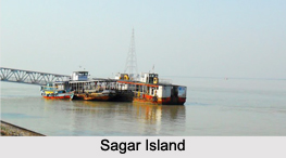
Sagar Island
Sagar Island is located on the continental shelf of Bay of Bengal, about 100 km (54 nautical miles) south of Kolkata. More specifically, this island is situated in the Ganges delta and comes under South 24 Parganas District. This island is spread over an area of about 224.3 square kilometers. Sagar Island is known to have 43 villages and the largest village among these is named "Ganga Sagar". This island is a Hindu pilgrimage site. It is thronged by a plethora of Hindus each year on the day of Makar Sankranti. They take a holy dip at the confluence of river Ganges and Bay of Bengal and also visit Kapil Muni Temple. The managing body of this island is the state government of West Bengal.Islands of West Bengal
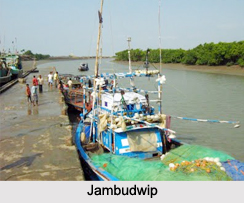
Jambudwip
Jambudwip is situated in the Bay of Bengal, about 8 km to the southwest of Bakkhali in the South 24 Parganas district. It is called an isolated island as it remains uninhabited, except in the fishing season (between the months of October and February). This island is valuable for fishermen as it provides drinking water and has a natural creek for safe harboring of boats.

Ghoramara Island
Ghoramara Island is located about 92 km south of Kolkata, in the Sunderban Delta complex of the Bay of Bengal. This island roughly occupies an area of about 5 square kilometers. It is important to note that erosion and rise in sea level have resulted in the sinking of this small island. Consequently, the population on this island is reducing.

Nayachar
Nayachar is an island located off Haldia in Purba Medinipur in the Hooghly River. The total area occupied by this island is about 64 square kilometers (25 sq mi). As of 2007, this island had a total population of about 2,500 people, but in government documents it is mentioned as "uninhabited". 54 square kilometers of land at Nayachar was given to PCR Chemicals Pvt Ltd on 15th of February by the West Bengal Government. This step was taken to carry out a feasibility test for setting up a chemicals hub on this island.

Other Islands of West Bengal
Morichjapi, Lohachara Island and Henry Island are the other Islands of West Bengal.


Share this Article:

Related Articles

More Articles in Geography of India


Geography of Uttar Pradesh
The fourth largest State in India UP is located in the Northern part of India whose area is 2,36,286 sq Kms.
Geography of Maharashtra
Covering an area of 308,000 sq. km, Maharashtra, the third largest state in India.
Geography of Kerala
Geography of Kerala includes plains, hills, valleys and coasts. With the Arabian Sea in the west, the Western Ghats in the east and networked by several rivers, Kerala enjoys diverse geographical features.
Geography of West Bengal
The geography of West Bengal is unique with high peaks of the Himalayan range in the north, the Bay of Bengal in the south and the remaining region is covered with both plains and plateaus.
Geography of Jharkhand
Geography of Jharkhand is comprised of the rich mineral resources and the highly agricultural prospect in this state.
Geography of Sikkim
Geography of Sikkim is characterised by a vast array of magnificent hillock that extends from one corner of the state to the other.
Geography of Meghalaya
The suitable climate, highland plateaus, rivers and the flora and fauna together forms the geography of Meghalaya.
Geography of Mizoram
Mizoram is surrounded by hills, valleys, rivers, waterfalls and lakes. The hills range from 1000 meters to 2000 meters. Rivers, lakes and waterfalls also play major role in forming the land of Mizoram.
Geography of Jammu & Kashmir
Jammu and Kashmir is encompassed by valleys. Some of the dominant valleys of the state are Kashmir Valley, Tawi Valley, Chenab Valley, Poonch Valley, Sind Valley and Lidder Valley etc. Jhelum River is the only major Himalayan River which flows through the Kashmir valley. Indus, Tawi, Ravi and Chenab Rivers are the major ones flowing through the region.
Geography of Daman and Diu
Daman and Diu is situated on the west coast of India and are the smallest union territories of India.
Geography of Goa
Geography of Goa occupies a prime location along the Konkan coastal belt on the western coast of India. The state is bordered by Maharashtra in the north and Karnataka in the south. The Western Ghats in the east contribute to the flora and fauna of Goa.
Geography of Arunachal Pradesh
Geography of Arunachal Pradesh reveals that it is a hilly tract nestled in the foot of Himalayas.
Geography of Kutch
Geography of Kutch District is covering an area of 45,612 km. Kutch District is the largest district in the state of Gujarat.
Geography of Ladakh
Geography of Ladakh mainly comprises the huge Karakoram Range with long stretch of cold desert which mark the region separately from the rest of the states of Indian subcontinent. Surrounded with the mountain ranges from all corners this small region separates Indian subcontinent from rest of the Asian continent.
Geography of Rajasthan
Geography of Rajasthan defines the dry topography with arid climate of the western mountain region.
Geography of Tamil Nadu
The Indian state of Tamil Nadu is located in the Northern hemisphere in the hot zone.