 The state of Goa is located in the western part of India. Even though it is India`s smallest state by area and the fourth smallest by population, its varied forms of water bodies has made it popular among travelers. Geographical feature called islands also form part of Goa"s topography. Some of the Islands of Goa are described below.
Vanxim
Vanxim Island is located in the Ilhas region of Goa. It occupies an area of about 800 square kilometers and has an elevation of about 8 m. After the Archdiocese of Goa sold this island to broker Mahendra Gaunekar, he became its master. This island was later sold to Ozone corporate. Vanxim Island serves as a home to Church of Santo Cristo and Chapel of the Miraculous Cross. It also houses Vanxim Cemetery and a temple devoted to goddess Sateri.
Anjediva Island
Anjediva Island is located in the Arabian Sea off the coast of Canacona in the South Goa district. This island is spread over an area of about 1.5 square kilometers. It is adorned with Angediva Fortress, which was built by the Portuguese and the shrines of Our Lady of Brotas and Sao Francisco de Assis. This island is under the direct jurisdiction of the Indian Navy. It is linked to the mainland by a breakwater. Presently, this island does not support any resident population.
St Estevam
 St Estevam Island is situated in Ilhas and has an elevation of about 8 m. The island is named after the Lusonised St. Steven. A notable spot on the island is the St. Estevam Church.
Cumbarjua
Cumbarjua is an island town located to the east of Goa`s capital namely Panjim, on the banks of Mandovi River. It has an elevation of about 8 m. The population of about 7,144 Cumbarjuemkars resides on this island in an area admeasuring 2,401,550 square meters.
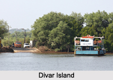
Divar Island
Divar Island is situated in the district of North Goa. This island has villages namely Piedade, Malar, and Naroa. It also houses temples and churches. Bonderam, Potekar and Feast of Our Lord Redeemer are the different festivals celebrated on this island.
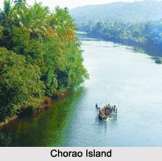
Chorao Island
Chorao is an island along the Mandovi River near Ilhas. This island comprises of three communities. It is adorned with many temples like Shri Devaki Krishna Bhumika Mallinath. Salim Ali Bird Sanctuary is situated in the western part of the island, covering an area of about 178 hectares and housing migratory and local birds of over 400 species.
Other Islands of Goa
The names of the other Islands of Goa are Sao Jacinto Island and Grand Island.


