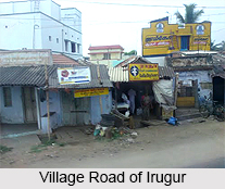
 Irugur is a famous panchayat town situated in Coimbatore district in the southern state of India, Tamil Nadu.
Location of Irugur
Irugur is situated at an altitude of 1,125 feet (343 feet) above mean sea level and between 11.02 degree North latitude and 77.07 degree East longitude.
Geography of Irugur
Singanallur, Sulur and Peelamedu are the other major towns surrounding Irugur. It is connected to Tirupur (32 km.) and Annur (25 km.) by road. The district headquarters is in the city of Coimbatore, which is about 11 km. east of Irugur. Irugur is one of the junctions in southern railways
Economy of Irugur
Irugur has a number of yarn manufacturing and processing units. It is a major hub for handling cargo and freights.
Population of Irugur
As per the census report brought out in 2001, Irugur had a population of 18,602. Males and females constitute an equal proportion of the population. In Irugur, 9% of the population is less than six years of age. The census report also states that the average literacy rate of Irugur is 73%. This is a progressive trend because the national average literacy rate is 59.5%. Out of it, the male literacy rate is 80% and the female literacy rate is 66%.
This article is a stub. You can enrich by adding more information to it. Send your Write Up to content@indianetzone.com