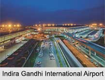
 Indira Gandhi International Airport is an important domestic and international airport in India named after former Prime Minister of India, Indira Gandhi. It was earlier known as the Palam Airport. With the inauguration of Terminal 2, the international terminal 1 was designated for the domestic operations. It is the busiest airport in India in terms of passenger traffic since 2009. It is the busiest airport for Airbus A320 aircraft. It became India`s and South Asia`s principal aviation hub.
History of Indira Gandhi International Airport
Until 1962, Safdarjung Airport was built in 1930 and it was the chief airport for Delhi. The aviation minister Praful Patel stated that the sanctioned Group of Ministers had approved to sell the administration rights of Delhi Airport to the Delhi International Airport Limited (DIAL) consortium and the Mumbai airport to the GVK Group on 31st January 2006. The old domestic Palam airport is recognized as Terminal 1 and handles domestic flights for all resources airlines. The new terminal`s building took 37 months to end and this terminal improved the airport`s whole passenger capability by 34 million.
Structure of Indira Gandhi International Airport
Indira Gandhi International Airport supplies as a foremost hub for numerous Indian airlines including Air India, Air India Regional, Indi Go, Jet Airways, Spice Jet, Go Air and Vistara. Around 80 airlines serve this airport.
Terminal 1: Terminal 1A was built in the late 1980s to organize Indian Airlines. It was used by Air India for its airbus actions. It is now closed. Terminal 1C is used simply for domestic arrivals. Terminal 1D is the recently built domestic departure terminal. It has 72 Common Use Terminal Equipment.
Terminal 2: It was opened on 1st May 1986. DIAL shifted operations of Go Air to terminal T2 from 29 October 2017 in order to carry on the extension work of Terminal 1.
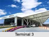
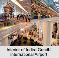
Terminal 3: The new Terminal 3 is a two-tier structure with the lower floor being the arrivals area, and the upper floor being a departures region. It has 168 check-in counters, 78 aerobridges at 48 contact stands, 54 parking bays, 95 immigration counters, 15 X-ray screening areas, for less waiting times, duty-free shops, and other characteristics. It is the world`s 8th largest passenger terminal.
The cargo terminal handles all the cargo operations. Terminals 4, 5 and 6 will be built at a later stage.
Delhi Airport has three near-parallel runways. It is the only airports in India to have been equipped with the CAT III-B ILS. It became the first Indian airport to operate two runways at the same time. It inaugurated its 3rd runway on 21 August 2008, has one of the world`s longest covered threshold displacements of 1,460 metres.
Airlines of Indira Gandhi International Airport
 Some of the Airlines operating at Indira Gandhi International Airport are Air Arabia, Air Canada, Air India, Air India Express, Air Asia India, All Nippon Airways, British Airways, Emirates, Flydubai, Indi Go, Jet Airways, Kuwait Airways, Malaysia Airlines, Qatar Airways, Thai Airways, Vistara, Zoom Air, United Airlines, Turkish Airlines, Kuwait Airways, Saudia, Iraqi Airways, China Airlines and many more.
Awards of Indira Gandhi International Airport
Indira Gandhi International Airport receives two awards for The Best Airport in Central Asia/ India and Best Airport Staff in Central Asia/ India at the prestigious Skytrax World Airport Awards in 2015. It also won the Best Airport award from the Airports Council International within 25–40 million annual passengers category in 2015. It won the esteemed Golden Peacock National Quality Award given by the Institute of Directors (India) in 2015. It has become Asia-Pacific"s single and one of the world"s few airports to accomplish a carbon neutral status.
Visiting Information of Indira Gandhi International Airport
The nearest railway station of Indira Gandhi International Airport is Palam railway station which is 18 kilometres from the New Delhi railway station. The airport is served by the Delhi Airport Metro Express train line. The airport is connected by the 8-lane Delhi Gurgaon Expressway.


