 A wetland refers to an area having sufficient water to support the growth of hydrophytic (i.e. dependent on water) vegetation. It is either permanently or temporarily saturated with water. Marshes, swamps, jheels, lagoons, mangroves, backwaters, estuaries, ponds, lakes and reservoirs are some of the names given to wetlands.
Types of Wetland
Depending on salinity, location and origin, wetlands can be broadly classified as fresh water wetlands, maritime wetlands, inland saline wetlands and agricultural wetlands.
Wetland Species
Wetlands support a variety of invertebrates and vertebrates. Some are wholly aquatic while others are dependent on wetlands only for completing their life cycle; for example insects such as dragonflies and mosquitoes. Some animals depend on wetland only for their food. The most spectacular of all the wetland species are the birds - mainly ducks and geese, storks and egrets and pelicans and flamingos. About 20 percent of the bird species of India can be found in the wetlands.
Different Indian Wetlands
 Wetlands are productive ecosystems which are also found in India. Most of the Indian Wetlands are directly or indirectly linked to river networks. The Indian government has identified several wetlands for conservation in the country. Some of these Indian Wetlands are given below.
Mangrove Forests
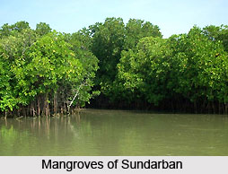
Mangrove forests are present all along the Indian coastline in sheltered estuaries, creeks, backwaters, salt marshes and mudflats. They are specifically the areas of Indian Wetlands. The mangrove area covers a total of about 4 461 square kilometers, which comprises around 7 percent of the world`s total mangrove cover. Prominent mangrove covers are located in the Andaman and Nicobar Islands, the Sundarbans delta, the Gulf of Kutch and the deltas of the Mahanadi River, Godavari River and Krishna River. Certain regions of the state of Maharashtra, Karnataka and Kerala also have large mangrove covers and Indian Wetlands.
Renuka Lake
Renuka Lake is located at an altitude of about 672 m above sea level in the district of Sirmaur. It"s name is based on the name of goddess Renuka. It has a circumference of about 3214 m. This lake is threatened by silt deposition and accumulation of waste of construction material. It has the distinction of being the largest lake of Himachal Pradesh.
Bhoj Wetland
Bhoj Wetland located in the city of Bhopal, Madhya Pradesh, comprises of two lakes namely, the Bhojtal and the Lower Lake. The former lake has an area of about 31 square kilometers, whereas the Lower Lake has an area of about 1.29 square kilometers. The noteworthy aspects of the lakes are water-birds.
East Kolkata Wetlands
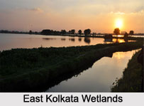
East Kolkata Wetlands, comprising of natural and human-made wetlands are located east of the city of Kolkata in West Bengal. On 19th of August, 2002, they were declared wetlands of international importance under the Ramsar Convention. They are spread over an area of about 125 square kilometers. These wetlands are utilized for the purpose of treating Kolkata`s sewage. The nutrients contained in the waste water help in maintenance of fish farms and play a vital role in agriculture.
Chilika Lake
Chilika Lake can be defined as a brackish water lagoon. It is located in Puri, Khurda and Ganjam districts of the Indian state of Odisha. This lake has maximum length of about 64.3 km (40.0 mi), maximum depth of about 4.2 m (13.8 ft) and occupies an area of about 1,100 square kilometers. It has the distinction of being the largest coastal lagoon in India and the second largest lagoon in the world.
Loktak Lake
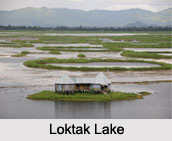
Loktak Lake is located close to Moirang in Manipur. It has the distinction of being the largest freshwater lake in north-eastern India. Manipur River and many small rivulets form the source of this lake whereas it"s outlet is formed by Ungamel Channel. The catchment area of this lake is about 980 square kilometers (380 sq mi). This lake has maximum length of about 35 km (22 mi), maximum breadth of about 13 km (8 mi) and average depth of about 2.7 m (8.9 ft). It has a surface area of about 287 square kilometers (111 sq mi). Loktak Lake is a part of the Loktak Hydropower Project on the Manipur River. Loss of vegetative cover in the catchment area of the lake and construction of Ithai barrage at it"s outlet has threatened this lake. Consequently, steps have been initiated to restore this lake.
Other Indian Wetlands
Some of the other Indian Wetlands are Kanjli Wetland, Vembanad-Kol Wetland, Ashtamudi Wetland and Harike Wetland.
Threats to Indian Wetlands
Factors like loss of vegetation, salinization, excessive inundation, water pollution, excessive development and road building and invasive species have threatened and damaged Indian Wetlands.
Significance of Indian Wetlands
Indian Wetlands are useful in waste treatment as it can clean off agricultural sewage and filter pollutants. For example, water hyacinth can remove 75 percent of the lead from contaminated water within 24 hours and also absorb cadmium, nickel, chromium, zinc, copper, iron and toxic substances such as pesticides. It has been recorded that the average animal protein production of an estuary is 7 times more than that of a natural terrestrial ecosystem. Thus, it can be said that Indian Wetlands are ecologically valuable.


