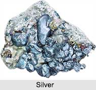
 Silver Mining is generally concentrated in different elements forming variety of minerals and ores. Silver has been used for thousands of years for ornaments and utensils, for trade, and as the basis for many monetary systems. Alchemists referred to silver by the name "Luna", as it was associated with the moon, as well as with the sea and various lunar goddesses. In India, foods can be found decorated with a thin layer of silver, known as "Varak". Silver is found in the soil as native silver, a mineral. As a mineral, it crystallizes in the cubic system. In a very rare cases, silver forms as crystals. Generally, found in thin sheets or as long wires and bundles of wires.
Silver Mines in India
Silver mined as a mixture in ores along with other metals such as copper, gold, lead, zinc, sulphur, antimony, arsenic or chlorine. India doesn"t have rich deposits of silver and most of the silver production is as by product in the production of metals like zinc, lead, copper and gold. Zawar mine in Udaipur is the largest silver producing mine in the country, while other important sources include Hindustan Zinc Smelter, Tundoo Lead Smelter, Hindustan Copper Limited, etc.
Uses of Silver
Silver metal is being used in sacred ceremonies, festivals, weddings and a lot of other cultural events. Other uses of Silver are as follows:
•For thousands of years, silver has been used for jewellery and all types of decorative items.
•It is used in silverware.
•Silver bromide and silver nitrate are used in photography.
•Silver conducts electricity well, so it is used in electrical products.
•Dentists in amalgam fillings use it.
•It is used in the production of bearings. As untarnished silver is the best reflector of light, it was used in ancient times to make mirrors.
•Sterling silver, an alloy of other metal (usually copper), was used as currency in the United States.
Silver is also used as a form of savings and investment in India. It is popular with the rural populace who invest in the metal to secure their savings. Silver is bought in the physical form as coins, jewellery, ornaments, utensils etc. and kept as a savings by consumers.


