 Indian Railways is one of India`s most effective transport networks, which unite the integral and varied social, cultural, economical and political aspects of the country. It is owned and managed by the Government of India. Indian Railways headquarters is located in New Delhi. Indian Railways is the 4th largest railway system in the entire world that carries around 8.107 billion passengers and about 1.101 billion tons of freight, annually and almost 3 million tons of cargo, on a daily basis. It has the distinction of being the 8th biggest employer around the globe. As of March, 2016 almost 1.331 million people are working in the network. At the end of 2015-2016, Indian Railways had almost 7216 stations spread across the country. From the mountainous terrains to the long stretches through the desert in Rajasthan, Indian Railways cover the vast and varied areas of the country from north to south and east to west, thereby connecting the entire nation.
Historical Development of Indian Railways
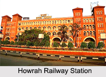
Indian Railways was established on 16th of April, 1853. Before the formation of Indian railways, the Great Indian Peninsula Railway (GIPR) had constructed India"s first passenger railway between Bombay (now, Mumbai) and Thane. It was opened in 1853. Post the formation of Indian railways, on 15th of August, 1854, the first passenger train steamed out of Howrah Railway Station and was destined for Hooghly, covering a distance of about 24 miles. Thus, the first section of the Eastern Railway Zone was opened to public traffic, inaugurating the beginning of railway transportation in east India. In south India, the Madras Railway Company opened the first railway line on 1st of July, 1856. It ran between Veyasarpandy and Walajah Road, covering a distance of about 63 miles. In north India, a railway line covering a length of about 119 miles was laid from Allahabad to Kanpur, on 3rd of March, 1959.
By 1880, the Indian Railway system had a route mileage of about 9000 miles, mostly spreading inward from the 2 major port cities of India namely, Bombay (now Mumbai) and Calcutta (now Kolkata). By 1895, India had started building its own locomotives, and in 1896 engineers and locomotives were send to help build the Indian railways.
Soon the Indian Railways network had spread to the regions which became the modern day Indian state of Assam, Rajasthan and Andhra Pradesh. A Railway Board was constituted in 1901, but the decision-making power was retained by the then Viceroy of India, Lord Curzon. The Railway Board operated under the guidance of the Department of Commerce and Industry. In 1907, almost all the rail companies were taken over by the government.
At the time of Indian independence in 1947, a large portion of the railways went to the then newly formed Pakistan. A total of 42 separate railway systems, including 32 railway lines owned by the former princely states of India, were merged as a single unit which came to be known as the Indian Railways. In 1952, a total of 6 zones came into being. As the Indian economy improved, almost all railway production units were diagnosed. By 1985, steam locomotives were phased out in favor of diesel and electric locomotives. The entire railway reservation system was streamlined with computerization in 1995.
Recent Developments in Indian Railways
Indian Railways has commenced upon various schemes, to further improve upon its services. These schemes have been massively motivated. The railway has changed from meter gauge to broad gauge. The Research Design and Standards Organisation at Lucknow, which is the largest railway research organization in the world was constituted in 1957. It is constantly devising improvements in the signaling systems, track design and layout, coach interiors, etc, along with improvements in locomotives, for better riding comfort and capacity. The workshops of the railways too have been given new equipment to create sophisticated coaches at Perambur and Kapurthala and diesel engine parts at Patiala. Locomotives are being made at Chittaranjan and Varanasi. 
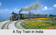
More routes and trains are constantly being added to the Indian railway network and services. The India Railways has a route of about 66,687 km. It covers about 119,630 kilometers of total track and about 92,081 km of running track. In 2015-2016, it was estimated that an average of about 13,313 passenger trains are operated by the India Railways, daily. Indian Railways has developed a wide variety of trains for the passengers. They are the heritage trains or toy trains on narrow gauge hill sections, luxury trains, express trains or long-distance trains, metro railways or underground railway system like Kolkata Metro and Delhi Metro, etc. These trains reflect an attempt made by the Indian railways to promote tourism in India and explore the unique beauty of the country.
Presently, there are 17 Indian railway zones and a total of 69 divisions divided under them. Indian railway stations are being given the shape of large complexes and besides having the usual amenities like retiring rooms and restaurants, they now include large office areas. Over bridges are now being replaced by underground passages providing more space above, on the platforms. Indian Railways is improving and enhancing by adopting world class standards in order to provide every possible facility to the passengers.


