 The Indian Postal Service is a government operated postal system and is a part of the Ministry of Communications of the Government of India. Under the Indian Postal Service, the Department of Posts is a major aspect, which is now traded as India Post.
History of Indian Postal Services
The history of Indian Postal Services dates back to the time before the introduction of postage stamps. It was prevalent in the ancient and medieval eras in India and eventually after the East India Company came to power, they opened the first post office in erstwhile Bombay in 1688 followed by similar ones in Calcutta and Madras. During the time of the British Empire, around 1861, there were 889 post offices handling nearly 43 million letters and over 4.5 million newspapers annually.
Milestones were covered like the passing of the Indian Post Office Act of 1898, which regulated efficient postal service. Then there was the world`s first official airmail flight which took place in India on 18th February, 1911, a journey of 18 km lasting for 27 minutes. After Indian Independence, the number of post offices was 23,344, which were primarily in urban areas. The number increased to 1, 55,015 in 2016 and 90 percent of these were in rural areas.
During the reign of the British East India Company, the British Empire lacked a uniform exercise of authority and thus the postal history of Indian states ran is a complex subject. During that time most of the states ran their own postal services. There were about 652 Princely States under the British government and most of them did not issue postage stamps. These states were divided into two main categories, first being the Convention States, had entered into a postal convention or agreement with the British government regarding mail. Secondly, there are the Feudatory States, who ran their own posts, and whose stamps were only valid within their borders.
Post Office Service in India
On October 1st, 1854, the Indian Post Office was recognized of national importance and was brought under the authority of Director- General. The purpose of the Indian Post Office is to deliver mails, remit money by money orders, accept deposits under Small Savings Schemes, provide life insurance cover under Postal Life Insurance (PLI) and Rural Life Insurance (RLI) and provide retail services like bill collection, sale of forms, etc. It also acts as an agent for Government of India in discharging other services for citizens such as Mahatma Gandhi National Rural Employment Guarantee Scheme (MGNREGS) wage disbursement and old age pension payments.
 As per 2017 reports, India has the largest postal network in the world with 1, 54,965 post offices of which 1, 39,067 are in the rural areas. For providing postal service, India has been divided into 23 postal circles, each headed by a Chief Postmaster General. These circles are further divided into regions and comprise of field units known as Divisions, which are again divided into sub divisions. In addition to these 23 circles, there is also a base to provide postal services to the Armed Forces of India. One of the highest post offices in the world is in Hikkim in the state of Himachal Pradesh operated by India Post at a height of 14,567ft.
Recently, Department of Posts, with the aim to generate revenue, has introduced a number of business products and services like Speed Post, Express Parcel, Business Parcel, Retail Post, e-post, e-payment, e-post office, Logistics Post, Business Post, etc.
Postage Stamps in Indian Postal Services
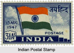
Postage stamps were first used in India in 1852 at district of Scinde, also known as Scinde Dawk. On 1st October 1854, the first Indian postage stamp was issued. Post independence, India`s first postal stamp was issued on 21st November 1947. Independent India`s first postal stamp depicted the picture of national flag of India. Mahatma Gandhi was the first person whose picture was depicted on free India`s stamp on 1948.
Postal Index Number of Indian Postal Services
Introduced on 15th August, 1972, the Postal Index Number or the PIN code is a 6 digit postal code. With 9 postal zones in the country; the first 8 are geographical regions, and the 9th is reserved for the Army Postal Service (APS). As of 2014, there are total of 19,101 PINs covering 154,725 post offices in India, with the exception of the Army Postal Service.
The PIN system is organised in the following way:
•The first digit indicates the zone.
•The first 2 digits indicate the sub-zone (or postal circle).
•The first 3 digits indicate a sorting district.
•The last 3 digits indicate the delivery post office.
Project Arrow
Launched in April 2008, Project Arrow plans to upgrade post offices in urban and rural areas, improving service and appearance into a vibrant and responsive organization and to make a visible and positive difference. The aim of the project is to create an effective, friendly environment for staff and customers, providing secure IT services and improving mail delivery, remittances. The Project Arrow plan has been implemented in more than 23,500 post offices, and `Look & Feel ` improvements have been made in 2,940 post offices.
Functions of Indian Postal Services
The functions provided by the Indian Postal Services are in plenty starting from the Railway Mail Service (RMS), Post Office Passport Seva Kendra (POPSK), Philately, Army Postal Service, Electrical Indian Postal Order, Postal Life Insurance, Postal Savings, Banking, Data Collection, E-Commerce delivery, etc. The functions of the Indian Postal Service are varied and serve different sectors but their primary purpose is to provide mail services to the customers.
Current Scenario of Indian Postal Service
Over the centuries, the Indian Postal Service has grown and has made its presence even in the remote areas of the country. New themes has found their place on the Indian postage stamps, with some stamps issued jointly with postal agencies of other countries, renewable energy sources, the local flora and fauna and even the special annual issues wishing season`s greetings. With technology advancements and to make the functions of the Indian Postal Services more efficient on 9th March, 2011 India Post launched an online e-post office. The portal provides electronic money orders, instant money orders, stamps for collectors, postal information, tracking of express and international shipments, PIN code search and registration of feedback and complaints online.


