Introduction
 Indian Mountains form an important part of the topography of India affecting climate, lives, settlement and economy. They have played an important role in building the ecosystem of the country. They have long added to the pristine beauty of the country, epitomizing majesty with their tall and regal presence and invite tourists, bewitching and mesmerizing them. They also have the capacity to evoke spirituality and sanctity. For centuries, these mountains have protected the nation`s borders from invading armies. Discussed below are some of these Mountains of India.
Indian Mountains of the Northern Region
Indian Mountains of the Northern Region includes some of the famous mountain ranges of the North India, a home calling to the various Mountain vegetations, species of animals, birds and trees.
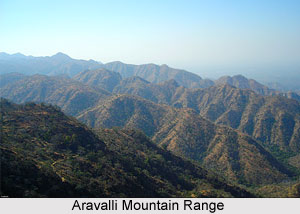 Aravalli Mountain Range : This is the oldest mountain ranges in India and runs for approximately 800 kms. It runs across Rajasthan in a northeast to southwest direction and the northernmost end of the range runs into Haryana and ends near Delhi. The highest peak of the Aravallis is the Guru Shikhar peak at Mount Abu. It rises to almost 1722 metres near Gujarat.
Karakoram Mountain Range : The Karakoram Range, lying in the state of Jammu and Kashmir, has over 60 peaks that stand at a height of over 7000 metres. Found here is the K2, the second highest peak in the world. Close to the north-western end of the Karakoram lays the Hindu Raj range and beyond this is the Hindu Kush Range. The Karakorams are bound on the South by the Gilgit, Shyok and Indus River.
 Himalaya Mountains : For centuries, these mountains ha ve protected the nation`s borders from invading armies. The most dominant mountain ranges in the country are the Himalayan Mountain Ranges. The Northern side of the Indian Subcontinent is defined by the Himalaya Mountains, the Hindukush and the Patkai Ranges. Himalaya Mountains are the highest mountain range in Asia that separates India from the Tibetan plateau. It is known as the King of mountains. The Himalayas have got their name from the Sanskrit word, Himalaya a tatpurusa compound meaning "the abode of snow" (from hima "snow" and alaya "abode"). Kalidasa has described the Himalayas, as the `King of mountains, enclosing divinity that stands between the two oceans as measuring rod as were, of the earth. The Indian Himalayas can be divided into three zones - the Shivalik Hill or the Outer Ranges on the southern wing, the Middle Ranges like the Pir Panjal and the Dhauladhar, and the Greater Himalayas with the highest and oldest peaks (many of these are in Nepal).
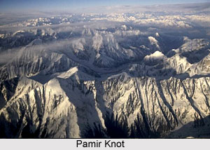
The Great Mountain Wall of the North Pamir knot lies in Central Asia, not far from India. It is often referred to as `the roof of the world`. From this knot emerge numerous mountain ranges. One of them is the Kunlun, which travels eastwards into Tibet. Another range, i.e. the Karakoram, enters Kashmir and runs southeast and incorporates the plateau of Aksai Chin. It broadens further east and is called the Kailash Range in Tibet. The Karakoram are majestic mountains comprising K2, the second highest mountain peak of the world. The Karakoram Pass has now gained extraordinary prominence. There are huge glaciers, i.e. highly sluggish rivers of solid ice and snow, in this region. The Baltoro and the Siachen are some of the legendary glaciers of this area.
 Shivalik Hills form a belt, which runs continuously from Jammu, Kangra valley, Sirmur district to Dehradun and finally ending up in the Bhabbar tracts of Garhwal and Kumaon. The Shivaliks extends about 1,689 km from southwest Kashmir through northern India into southern Nepal. The hills consist of 6000 meters of layered rocks. They are known as the sub-Himalayas or the foothills and were formed by the erosion caused by the rise of the Himalayas.
Along the southern edges of Himachal Pradesh , from the Kangra valley to the Sirmaur regions the Shivalik hills are all developed. In the valleys between the Shivalik and the main northern ranges are located the Doon valleys. Dehradoon has emerged out to be the best-known towns of the Sivalik regions and also an important tourist hub.
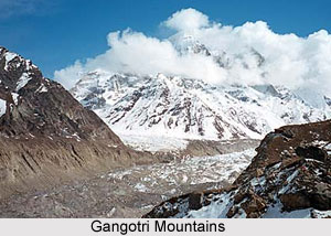
Gangotri Mountains are a subsection of the Garhwal Himalayas, which is located in the northern state of India, Uttarakhand. The well-known Gangotri glacier and several peaks well known as religious destination or for their difficult climbing routes are located here. Some of the popular peaks of the Gangotri Mountains include Chaukhamba, Kedarnath, Thalay Sagar, Meru, Shivling peak and Bhagirathi.
Indian Mountains of Eastern Region
Indian mountains of eastern region consist of the different mountain ranges and hills located in the states of Eastern India like West Bengal, Bihar, Jharkhand and Orissa.
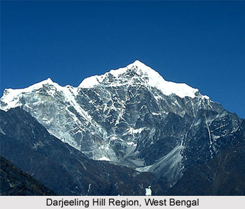
Mountains of West Bengal : Darjeeling Himalaya Hill regions, Falut, Poobong, Tonglu, Sandakfu, Singalila Ridge are the innumerable mountains and peaks which are present in the state of West Bengal. The Himalayan region comprises Singalila Range which has a height of 3636 meters, Darjeeling-Kurseong range which measures 2600 metres, Chola range which measure 1704 metres and Buxa-Jayanti range which measure about 1400 metres. Other hills involve Ayodhya Hills in Purulia that measure 855 metres, Biharinath in Bankura which measures 451 metres, Susunia which measure 448 metres and is located in Bankura. The hillocks are Mukutmanipur which is 200 metres in length, Mama Bhagne Hillock which has a height of 105 metres and hillock of Eastern Kolkata which has a height of 20 metres. Other hills are Tonglu hills, Tiger Hills, Ghum Hills, Deolo Hills, Gorbabu Hills, Durpin Hills, etc.
Mountains of Bihar : Bihar consists of hills like Rajgir Hills, Barabar Hills, Kaimur Range which is about 483 kms in length, Brahmayoni Hills, Pretshila Hills and Ramshila Hills.
 Mountains of Jharkhand : Mountains of Jharkhand are Parasnath Hills near Gomoh which is 3,544 feet, Dubaur in Kodarma which measures 1,970 feet, Singarsi Peak in Sahibganj which measures 1,503 feet, Kotwar Pahar in Kalikapur which is about 1,503 feet, Lapsa Baru in Chaibasa which measures 1,044 feet, Trikut Parvat in Jamtara which is 1,033 feet and Sideshar in Mushabani which measures 817 feet are the various mountains located in Jharkhand.
Mountains of Orissa : Orissa boasts of several mountains like Singaraja Mountain in Saroda which measures 4,631 feet, Nimgiri near Balangir, which is 4,002 feet, Megasini in Jajpur which measures 3,819 feet, Ganpati Pahar near Jajpur which measures 3,655 feet, Chata Danda in Jajpur which measures 3,635 feet, Amjhori Hills near Jajpur which measure 3,550 feet, Mankarnacha near Talcher which measures 3,374 feet, Deva Giri near Phulbani which is about 3,165 feet, Balia Pahar near Bolanikhodan which measures 3,117 feet, Mahendra Giri near Sorada which measure 2,898 feet, Betjharana Parbat in Bhadrakh which measure about 2,717 feet, Raegara Hills in Asika which measure 2,137 feet, Thakurani Pahar in Bada which measure 2,066 feet, Goaldei in Buguda which measure 1,935 feet, Banspani Pahar in Barabil which is 1,829 feet, Bola in Jajpur which is 1,667 feet and Malayagiri in Talcher which measure 1,627 feet.
Indian Mountains of Western Region
 Indian mountains of western region consist of various mountain peaks in the states of western India namely, Gujarat and Maharashtra. The presence of these mountains influences the temperature and climatic conditions in western India as well as the entire nation. These mountains have beautified India and also attract tourists to western part of India. The Indian mountains of western region are given below.
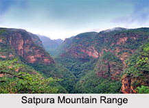
Mountains of Gujarat : The Aravalli Mountain Range, Vindhya Mountain Range, Satpura Mountain Range and Sahyadris Mountain Range are the various mountain ranges located in the state of Gujarat. Girnar is known to be the highest mountain range in Gujarat, with a height of about 1,145 meters. Satpura range is present between the Tapti and Narmada rivers. Taranga Mountains is located in the area between Visnagar and Mehsana. Parner Mountains and Saler Muler are parts of Sahyadri Range. Saurashtra consists of two peaks, known as the Bardo Hills and Venu Peak. Bardo has a height of about 625 meters and Venu Peak has a height of about 29 km.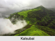 Gujarat`s other mountains include Shetrunjaya Hill near Palitana, Talaja Hills and the hills of Sana and Lor. Kutch region of Gujarat possesses several hills like Pranjal, Pachham and Khadir.
Mountains of Maharashtra : Satpura Mountain Range, Kalsubai, Ghanchakkar and Taramati are the different mountains present in the state of Maharashtra. Kalsubai is located in Nashik District. It has a height of about 1646 meters. Ghanchakkar, a part of Sahyadri Mountain Range has a height of about 5,026 feet. Taramati has a height of about1431 m. Some of the other mountains of Maharashtra are Purandar, Torna, Salher and Dhodap.
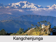
Kanchenjunga<
Kanchenjunga is a mountain located in Sikkim in India and also in Nepal. It has the distinction of being the third highest mountain in the world. Its parent mountain range is the Himalayas. At its highest point, Kanchenjunga reaches a height of about 8,586 m (28,169 ft).
Nanda Devi
Nanda Devi is located in Chamoli District in the Indian state of Uttarakhand. It has the distinction of being the second highest mountain in India, the highest mountain located entirely within the country and the 23rd highest peak in the world. Its parent range is Garhwal Himalayas. At its highest point, Nanda Devi reaches a height of about 7,816 m (25,643 ft). 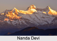
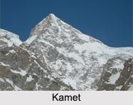
Kamet
Kamet is situated in Chamoli District in Uttarakhand. It has the distinction of being the second highest mountain in the Garhwal region of Uttarakhand and the third highest mountain in India. The mountain seems to be a giant pyramid topped by a flat summit area with two peaks. At its highest point, Kamet reaches a height of about 7,756 m (25,446 ft).
Saltoro Kangri
Saltoro Kangri is located on the Actual Ground Position Line between the Indian controlled territory in the Siachen region and the Pakistani controlled territory west of the Saltoro Range. The parent range of Saltoro Kangri is Saltoro Mountains, which is a sub-range of the Karakoram Range. At its highest point, Saltoro Kangri reaches a height of about 7,742 m (25,400 ft).
Saser Kangri
Saser Kangri is located within the Indian state of Jammu and Kashmir. Its peak has the distinction of being the highest peak in Saser Muztagh, which is the easternmost sub-range of the Karakoram Range. Saser Muztagh is called the parent range of Saser Kangri. At its highest point, Saser Kangri reaches a height of about 7,672 m (25,171 ft). Saser Kangri II East reaches a height of about 7,518 m (24,665 ft), whereas Saser Kangri II West has a height of about 7,500 m (24,600 ft). Saser Kangri III reaches a height of about 7,495 m (24,590 ft).
Mamostong Kangri
 Mamostong Kangri is located about 30 km east-southeast of the snout of the Siachen Glacier. Its peak has the distinction of being the highest peak in the remote Rimo Muztagh, which is a sub-range of the Karakoram Range in Jammu and Kashmir. At its highest point, Mamostong Kangri reaches a height of about 7,516 m (24,659 ft).
Teram Kangri
Teram Kangri group is a mountain massif in the remote Siachen Muztagh, which is a sub-range of the Karakoram Range. Siachen Muztagh is called the parent range of Teram Kangri. It is important to note that Teram Kangri is controlled by India and China and claimed by Pakistan.
Jongsong Peak
Jongsong Peak is a mountain in the Janak section of the Himalayas, situated at the China-India-Nepal tri-point. Himalayas form the parent range of Jongsong Peak. At its highest point, Jongsong Peak reaches a height of about 7,462 m (24,482 ft).
Other Indian Mountains
The names of some of the other Indian Mountains are Ghent Kangri, Apsarasas Kangri, Kirat Chuli, Kangto and Pauhunri.


