 India being one of the biggest peninsulas in the world is blessed with 13 major ports. These ports have an important role to play in the economy of the country. This fact can be comprehended from the fact that about 95 percent by volume and 70 percent by value of India"s international trade is carried on through maritime transport. Given below are the 13 major ports of India.
Cochin Port
Cochin Port is located in Kochi on the Laccadive Sea. It was opened on 26th of May, 1928.
The port is handled by the Cochin Port Trust and Dubai Ports World. It is owned by the Ministry of Shipping, Government of India.
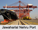
Jawaharlal Nehru Port
Jawaharlal Nehru Port or Nhava Sheva, the largest container port in India is located east of Mumbai in Maharashtra. It is handled by the Jawaharlal Nehru Port Trust and owned by the Government of India. This port is also the terminal of the Western Dedicated Freight Corridor as proposed by the Indian Railways.
Kandla Port Trust
 Kandla Port Trust or Kandla is a seaport located near the city of Gandhidham in the Kutch District of the Indian state of Gujarat. It is the largest port of India by volume of cargo handled. Kandla was constructed in 1950s after the Partition of India. The Port of Kandla Special Economic Zone (KASEZ) was the first special economic zone to be established in India and in Asia.
Kamarajar Port Limited
Kamarajar Port Limited or Ennore Port is known as Asia"s energy port. It is located on the Coromandel Coast about 24 kms north of Chennai Port in Chennai. It has the distinction of being the first corporatized port of India and is the 12th major port of the country. The port was opened in 2001. It is handled and owned by the Kamarajar Port Limited.
Mormugao
Mormugao is a sub-district and a municipal council in South Goa district in the Indian state of Goa. It received the designation of a major port in 1963. It is important to note that the Mormugao port has contributed immensely to the growth of maritime trade in India. It is the leading iron ore exporting port of India with an annual throughput of about 27.33 million tonnes of iron ore traffic.
Mumbai Port Trust
Mumbai Port Trust is located midway on the west coast of India on the natural deep-water harbour of Mumbai, Maharashtra. It is owned by the Government of India.
Madras Port
Madras Port or Chennai Port is an artificial and all-weather port with wet docks. It has the distinction of being the second largest container port of India and the largest port in the Bay of Bengal. It was opened in 1881. The Chennai Port Trust has the responsibility of handling this port and also owns it.
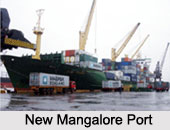
New Mangalore Port
 New Mangalore Port is a deep-water and all-weather port located at Panambur, Mangalore in the Indian state of Karnataka. It has the distinction of being the seventh largest port in India and is the only major port of Karnataka. It was opened on 4th of May, 1974. New Mangalore Port Trust (NMPT) has the responsibility of handling this port. This port is owned by the Ministry of Shipping, Government of India.
Port of Kolkata
Port of Kolkata, a riverine port is located in the city of Kolkata, around 203 kms (126 mi) from the sea. It has the distinction of being the oldest operating port in India. This port was established by the British East India Company. The port was opened in 1870. Kolkata Port Trust has the responsibility of handling this port. Kolkata Port Trust under the Ministry of Shipping, Government of India owns this port. The port has two distinct dock systems - Kolkata Docks at Kolkata and a deep water dock at Haldia Dock Complex, Haldia.
Paradip Port
Paradip Port, an artificial and deep-water port is situated on the east coast of India in the district of Jagatsinghpur in Odisha. It was opened on 12th of March, 1966 and is handled by the Paradip Port Trust.
Tuticorin Port Trust
Tuticorin Port Trust or V.O.Chidambaranar Port is an artificial and all-weather port situated in Tuticorin, Tamil Nadu. It has the distinction of being the second-largest port, second all-weather port and the third international port of Tamil Nadu and the fourth-largest container terminal in India. It was designated a major port on 11th of July, 1974. V.O.Chidambaraner Port Trust has the responsibility of handling this port. The port is owned by the V.O.Chidambaranar Port Trust under Ministry of Shipping, Government of India.
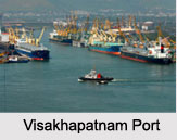
Visakhapatnam Port
Visakhapatnam Port is the second largest port of India considering the volume of cargo handled by it. It is located on the east coast of India in Visakhapatnam, midway between the Chennai and Kolkata Ports. It was opened on 19th of December, 1933. This port is handled by Visakhapatnam Port Trust and owned by the Ministry of Shipping, Government of India.
Port Blair Port
Port Blair Port is the youngest major port of India. This port was established in 2010. The port is of strategic importance to India and is closer to two international shipping lines, that is, Saudi Arabia-Singapore and US-Singapore.
Non-Major Ports of India
India has 200 non-major ports in different states. Some of these states are Maharashtra, Gujarat, Tamil Nadu, Karnataka, Kerala, Andhra Pradesh, Odisha and Goa.


