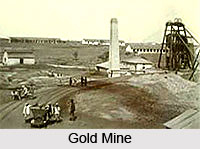
 Indian Gold Mines do not figure many in number. Gold is one of the foremost items of consumption in India. The refined gold reserves of the country are estimated to be over 10000 tons with the majority of this gold being held as jewellery. There are a number of agencies which have the licenses to import gold and silver according to the rate of demand in the country.
The only mine producing gold in India is Hutti Gold Mines Limited (HGML). It has reserves of approximately 600 tons and produces on an average 3 tons of gold a year. It is owned by the Government of Karnataka and is engaged in the mining as well as production of gold. It is the only company in India which produces gold by mining and processing the gold ore. HGML has two plants which are located at Hutti and Chitradurga. The main mine is located at Hutti in Raichur district, along with the satellite branches of Uti and Hirabuddini. Hutti is an underground mine, Uti is an open-cast mine while Hirabuddini is an exploratory mine. The Chitradurga Gold Unit consists of an exploratory underground mine at G. R. Halli in Chitradurga district as well as an open-cast mine located in Ajjanahalli in Tumkur district. Gold is mined from the main gold mine located at Hutti and other satellite mines. The mines which are owned by Hutti are located in the Hutti-Muski precambrian greenstone geological belt. This area contains both extractable native gold and gold-bearing sulphides.
Kolar Gold Fields
Kolar Gold Fields was one of the major Gold mining centres in India and is located in the Kolar district in Karnataka, close to the city of Bengaluru. The mine is considered the world`s second deepest gold mine. The Kolar Gold Mines were taken up for systematic exploitation by John Taylor and Sons in 1880. The mines were handed over to the Government in 1972 and BGMC (later BGML) was formed. It thus became a Public Sector Undertaking under the Department of Mines in the Government. The BGML was mainly involved in mining in its captive mines in Kolar Gold Field (KGF), Karnataka and Andhra Pradesh and production of gold in KGF. As a diversification, the Company also undertook mine construction, shaft sinking, manufacture of mining machinery and other fabricated items for outside clients for which it had set up a Mine construction and Engineering Division. It later ceased operations due to losses.
The production of gold in India in recent times has come from the copper smelters as a by-product. Birla Copper and Sterlite have produced more gold than the only working gold mine at Hutti in Karnataka.


