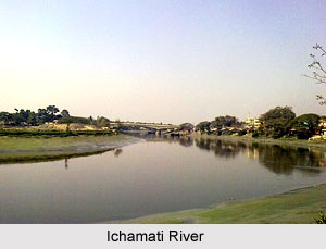
 Ichamati River is actually a trans-boundary river that flows through India and also Bangladesh. It acts as a boundary between the two nations. The river is having trouble with siltation that leads to slender flow of water in the dry season and floods in the rainy season.
Ichamati Flow
Ichamati River is now in three parts -
* The longer part flows from the Mathabhanga River, a distributary of the Padma, and after flowing for 208 km joins the Kalindi River near Hasnabad in North 24 Parganas and Debhata in Satkhira District.
* Once the main river west of Dhaka and
* Ichamati of Dinajpur. Rennel`s map of 1764-66, shows the last two rivers as one. According to a number of hydrologists, the three Ichamati Rivers, in the past, were a single channel.
Flow of Ichamati River
Mathabhanga River begins from right bank of Padma at Munshiganj in Kushtia District in Bangladesh. It splits near Majidia in Nadia District in India, creating two rivers, Ichamati and Churni. Ichamati enters Bangladesh near Mubarakpur, after negotiating length of 19.5 km in India. The river flows 35.5 km in Bangladesh and then enters India at Duttaphulia in Nadia District. The river forms the border for Indian and Bangladesh.
The Bhairab once flowed from the Ganges, across the present beds of the Jalangi, and further eastwards towards Faridpur. The Bhairab is no more a very active river. The Mathabhanga is a younger stream than Jalangi and it was not till very recently that the river completed its junction with the Hooghly by adopting the River Churni (now its lower reaches) for its main course. Earlier most of the water of the Mathabhanga ran off to the east down the Kumara, Chitra, Coboduk (Bhairab), and Ichamati, but all these escape routes have been shut off, except a small amount for the Ichamati. The point to note is that while earlier the rivers in the region flowed in a south-easterly direction, but later some force pulled the Jalangi and the Mathabhanga in a south-westerly direction. The inference is that it occurred because of a local subsidence, which was active for some period prior to 1750 and which has since become inactive
While the bed of the Ichamati River is 14 feet higher than that of the Mathabhanga, that of the Churni is lower than Mathabhanga by six inches. During dry phase the level of water in the Mathabhanga is higher than that of the Padma. Due to this, during dry spells, no water enters the Ichamati.
The river faces acute problem of industrial pollution and forcible occupation of land by people. Striking environmental hazards resulting from lack of encroachment, sanitation facilities, groundwater pollution like arsenic problem, destruction of aquatic flower, fauna are some of the burning issues of the area that needs to be taken care of trough participatory mechanism.
Ichhamati River and its tributaries form a large oxbow lake complex in North 24-Paraganas district near Bangaon. The agricultural chemical fertilizers and weed infestation, particularly with water hyacinth (Eichhornia crassipes) is a major concern because it is covering the surface of lake waters.


