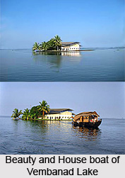
 Hydrography of Vembanad Lake covers the extension of the lake in Kerala, and the aquatic lifestyle. Vembanad Lake is the largest brackish lagoon in Kerala. It covers an area of two hundred square kilometres and is surrounded by the districts of Alappuzha, Kottayam and Ernakulam.
Vembanad Lake or Vembanad wetland system is largest wetland system in India. Of this, an area of 398.12 square kilometres is located below the MSL and a total of 763.23 square kilometres area is located below 1 m MSL. Vembanad Lake is bordered by Alappuzha district, Kottayam district, and Ernakulam district. It is situated at the sea level, and is separated from the Arabian Sea by a narrow barrier island. Vembanad Lake surrounds the islands of Pathiramanal, Perumbalam and Pallippuram.
Vembanad Lake is about 14 kilometres wide at its widest point. The lake is a part of Vembanad-Kol wetland system which extends from Alappuzha District in the south to Azheekkode in the north, making it by far, India`s longest lake at just over 96.5 km in length. Vembanad Lake is fed by ten rivers flowing into it including the six major rivers of central Kerala namely the Achenkovil River, Manimala River, Meenachil River, Muvattupuzha River, Pamba River and Periyar River. The total area of the lake is 15,770 square kilometres which accounts for 40 percent of the area of Kerala.
Tourism of Vembanad Lake
Vembanad Lake is one of the major tourist spot of Kerala, because of its scenic beauty. The most popular location on the shores of the lake is the Kumarakom Tourist Village situated on the east coast of the lake. Kumarakom Bird Sanctuary is located on the northern fringes of Kumarakom village, which adds the beauty of the lake.
An exclusive feature of the Vembanad Lake is 1252 meter-long Thanneermukkom salt water barrier. Thanneermukkom salt water barrier was erected as a part of the Kuttanad Development Scheme. It facilitates the local villages to prevent tidal action and intrusion of salt water into the Kuttanad low-lands. It is the largest mud regulator in India also. This barrier essentially divides the lake into two parts, one with brackish water perennially and the other half with fresh water fed by the rivers draining into the lake. This barrier has helped the farmers in Kuttanad by freeing the area of salinity and adding another crop in dry season.


