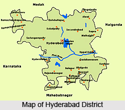
 With a happy blend of tradition and modernity, the Hyderabad district is situated in the state of Telangana. The district was the seat of the Asaf Jahi dynasty, and came to be known as the city of Nizams. Resplendent in the architectural legacy left behind by the Nizams, the district now hosts a contemporary and modern lifestyle, catering to the many different communities of people residing in the state.
History of Hyderabad District
The history of Hyderabad district is one of bewitching palaces, timeless corridors, fairy-tale courtyards and whispering waterways. It was the seat of the extremely wealthy Nizams of Hyderabad. Being the fifth-largest city of India, Hyderabad was founded in 1590 by Muhammad Quli, the fourth king of the Qutab Shahi dynasty. After Aurangzeb`s death in 1707, Mughal control over this part of India rapidly waned and the Asaf Jahi viceroy who had been installed to look after the interests of the Mughal Dynasty broke away to establish their own independent state.
 The Hyderabad district was formed a year after Indian Independence on 1948 after brutal Police Action of government of India by merging Atraf-a-Balda district and Baghat district. Previously a taluk in Atraf-a-Balda, Baghat was made a separate district in 1931-34 under the subedar of Medak division. In 1978 Hyderabad district was later split into Hyderabad Urban District and Hyderabad Rural District. The Hyderabad Urban District was made by 4 Talukas namely; Charminar, Golkonda, Mushirabad and Secunderabad Talukas. Hyderabad rural district was later renamed to Ranga Reddy District.
Geography of Hyderabad District
The district of Hyderabad is located between 1 degree 11 minutes of the Northern Longitude and 78 degree 27 minutes of the Eastern Longitude. Situated on the Deccan plateau, it occupies an area of 217 sq. km. The climate of Hyderabad district is mostly tropical wet and dry. During summer the maximum temperature is 40 degree Celsius and the minimum temperature is 22 degree Celsius and during winter the minimum is 13.8 degree Celsius. While during the monsoon season the temperature goes down at times. Thus, for most parts of the year the weather and climate of Hyderabad district remains fairly moderate. The average rainfall in the district is 89 cm, from June to September.
Demography of Hyderabad District
As per the reports of Census India 2011, the total population of Hyderabad district was 3, 943,323 with a majority of Hindus constituting 52 percent of the population. Other religions included Muslims (43 percent), Christians (2 percent), Jains (0.5 percent), Sikhs (0.29 percent) and Buddhists (0.03 percent) and the rest 1.58 percent from different religious backgrounds. The Hyderabad district has a population density of 18,480 inhabitants per sq. km and a sex ratio of 943 females for every 1000 males with a literacy rate of 80.96 percent. Over the decade, 2001 to 2011, the rate of population growth in the district was 4.71 percent.
 Economy of Hyderabad District
The non-agriculture sector is the basis of the economy of the district covering 98.09 percent of the total Geographical area of the district put to Non-Agricultural uses indicating predominance of non-agricultural activities in the district. Hyderabad is known as the city of pearls, lakes and, lately, for its IT companies. Products such as silverware, saris, Nirmal and Kalamkari paintings and artefacts, unique Bidri handcrafted items, lacquer bangles studded with stones, silk-ware, cotton ware and handloom-based clothing materials are made and traded through the city for centuries. The prime exports of the region are Basmati rice and spices, medical transcription and oil exports.
Administration of Hyderabad District
Hyderabad District was once governed by Andhra Pradesh. Now it is included with Telangana, a newly formed state. All the rural areas of erstwhile Hyderabad District have been included in Ranga Reddy District, while the area of Municipal Corporation of Hyderabad (excluding a small part), Secunderabad Cantonment, Lalaguda and Osmania University are included in Hyderabad District. There are 66 villages in the District and they are grouped into erstwhile talukas, viz., Charminar, Golconda, Musheerabad and Secunderabad.
The lower level administrative set-up was restructured by the Government and consequently the Revenue Mandal was setup. Hyderabad District was divided into four Revenue Mandals Viz., Charminar, Golconda, Musheerabad and Secunderabad with effect from 25th June, 1985. Hyderabad Urban Development Authority (HUDA) was constituted with the jurisdiction extending over an area of about 1154 sq km including the Municipal Corporation of Hyderabad.
Tourism in Hyderabad District
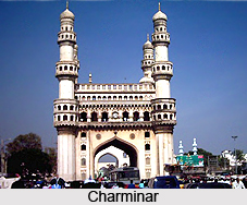
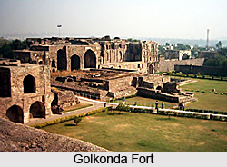
Charminar, Golconda fort, Falaknuma Palace are some of the popular tourist attractions in Hyderabad districts. Besides the historical monuments a number of religious buildings are also located within the region. There are other tourist attractions of Hyderabad Districts like Taramati Baradari, Venkateswara Temple, Salar Jung Museum, Nehru Zoological Park, Shilparamam and many other places. Auto rickshaws, Private Taxis and buses are popular mode of transportation. Hyderabad is easily accessible through all modes of transport from within and out of India.
Visiting Information on Hyderabad District
The nearest railway station is the Hyderabad station at a distance of 3 km and the Rajiv Gandhi International Airport is the closest at a distance of about 26 km.


