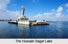
 Hussain Sagar is a lake located in Hyderabad in Andhra Pradesh, India. It is also known as the Tank Bund. This lake separates Hyderabad from its twin city Secunderabad. A special feature of this lake is a large monolithic statue of Gautama Buddha, carved on an island in the middle of the lake, in 1992. This statue is 16 m tall and approximately 350 tonnes. Characteristically, it is an artificial lake that stores water, perennially fed by canals from river Musi.
History of Hussain Sagar Lake
The Hussain Sagar Lake was constructed in 1563 by Hazrat Hussain Shah Wali. Thus, the lake is named after him. The establishment of this lake marked the rule of Ibrahim Quli Qutub Shah. It was built across a tributary of the river Musi. Hussain Sagar functioned as the prime source of water supply to Hyderabad before Himayat Sagar and Osman Sagar were built on river Musi.
Geography and Hydrography of Hussain Sagar Lake
The Hussain Sagar Lake has a maximum length of about 3.2 km, maximum width of about 2.8 km and maximum depth of about 32 feet. It occupies an area of about 5.7 square kilometers. River Musi drains its water in this lake.
Economic Values of Hussain Sagar Lake
Boating and water sports have made Hussain Sagar Lake valuable for Hyderabad. This lake is famous for regattas. Since 1971, regattas are held here, jointly by the EME Sailing Association and the Secunderabad Sailing Club. Hyderabad Sailing Week is conducted here since 1984, when the first laser boats were introduced by the Laser Class Association of India. The event has grown from 10 laser entries in 1984 to 110 laser entries in 2009. In August 2009, monsoon regatta was also introduced in this lake, in which sailors from all over India participated. Different classes of sailboats and yachts were raced including 4 J24, 18 hobie cat and 47 optimist (dinghy), in this event.
Started functioning in 2009, the Yacht Club of Hyderabad instituted the Monsoonregatta.com. It is located near Sanjeevaiah Park in Hyderabad. The club started with just 3 boats, but gradually increased its count to 45. Some of such boats are lasers, optimists, omegas, kayaks along with many safety and rescue vessels. This club trains youngsters to compete in national level boating competitions.
To enhance this lake"s capacity for tourism, Andhra Pradesh tourism has provided new and better facilities like speed boats, motor boats, seater launch etc. Starlit dinner on board and private parties also can be arranged on the launch.
Ecological Crisis Faced by Hussain Sagar Lake
Various uncontrolled activities are responsible for deteriorating the water quality of Hussain Sagar Lake, during the last three decades. Sewage from the twin cities of Hyderabad and Secunderabad is released into this lake, without any prohibition. The entire ecosystem of Hussain Sagar Lake has been compromised, due to heavy anthropogenic pressures such as unplanned urbanization. The depth of this lake has significantly reduced due to siltation and accumulation of plant debris. A 2008 study of the lake`s water and sediment has found that it has exceeded its eutrophic condition, reaching hypereutrophic status. Change in the biological nature of this lake has resulted in the reduction or complete disappearance of some important species, residing in this lake.
Restoration of Hussain Sagar Lake
To restore the quality of Hussain Sagar Lake, interventions by Andhra Pradesh Pollution Control Board (AAPCB) became imperative in terms of a project. This project needed approval and financing, for which a project feasibility report was also prepared. A sewage treatment plant on the western side of the lake was also commissioned. In spite of these efforts, huge amount of untreated sewage and industrial effluents continue to flow into this lake.
Visiting Information
Hussain Sagar can be reached by MMTS train stations at Necklace Road, James Street and Sanjeevaiah Park. The Necklace Road runs along the lake and connects important locations on its banks. Nearest railway station to this lake is the Hussain Sagar Junction, controlling cabin with three routes diverging towards Hyderabad, Secunderabad and Begumpet. It was earlier a 2 platform railway station but was dismantled in the mid 1980s.
Related Articles:
Lakes of India
Water Resources in India
Kolleru Lake
Shamirpet Lake
Pakhal Lake
Osman Sagar
Fox Sagar Lake


