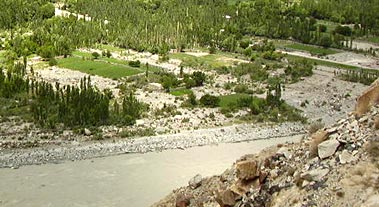
 Hunza River is located in Pakistan occupied Kashmir (POK). More specifically, this river is situated in Hunza in Gilgit-Baltistan. This river is considered to be the principal river of Hunza. It is also an Indian river as it flows into the Indus River and forms its tributary.
History of Hunza River
It is considered that in the 1870s, a British General and a garrison of soldiers on horseback investigated the Hunza River Valley.
Geography of Hunza River
Globally, Hunza River can be pinpointed at coordinates 35 degrees 55 minutes north and 74 degrees 22 minutes east.
Course of Hunza River
The Hunza River flows in the northern areas of Pakistan. It is formed by the convergence of the Kilik and Khunjerab nalas or the gorges, which are fed by glaciers. The Gilgit River and the Naltar River join it before it flows into the Indus River. The river cuts through the Karakoram Range, flowing from north to south. The Karakoram Highway crosses the Hunza River near Hunza and Nagar valleys. The river is dammed in part of its journey.
Valley of Hunza River
Hunza Valley is formed by the Hunza River. It is a mountainous valley near Gilgit in the northern areas of Pakistan. The Hunza Valley is situated at a height of about 2,438 metres or 7,999 feet. The territory of Hunza is about 7,900 km. Karimabad is the capital of this valley and was previously called Baltit. This main town of the Hunza Valley is a very popular tourist destination in Pakistan because of the fantastic scenery of the surrounding mountains like Rakaposhi, Bojahagur Duanasir II, Ultar Sar, Hunza Peak, Ghenta Peak, Darmyani Peak, and Bublimating or the Ladyfinger Peak. All these peaks have a height of almost 6,000 m (19,685 ft) or even more.
In January 2010, the Hunza Valley was completely blocked post the Attabad landslide disaster. Consequently, parts of the Karakoram Highway were completely covered and a new lake (presently known as the Attabad Lake or Gojal Lake) was also formed. It was formed as the Hunza River backed-up. This lake was about 30 kilometers in length and its depth was measured as 400 feet.
Related Articles:
Indian Rivers
Himalayan Rivers
Coastal Rivers
Deccan Rivers


