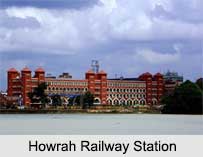
 Howrah Railway Station is one of the leading railway stations in India which serves Kolkata and Howrah along with other places. Around 673 passenger trains pass through the station each day requiring its 23 platforms. The station is located in Howrah on the west bank of the Hooghly River. 1273 stations across India are directly connected to Howrah Railway Station. Today Howrah Station is looked at as one of the largest railway terminals in the country.
History of Howrah Railway Station
Howrah Railway Station was founded in 1854 during the British era. In the same year, the first train ran from the station to Pandua. In 1854, during the period of British Colonial government, the authorities had started constructing a second railway link from Kolkata to the coalfields in Bardhaman district after the first one from Mumbai to Thaney, built in 1853. Howrah used to be a small town near the river Hooghly then. A single line track was made at first; a station was also built there but it was meant for goods only. In 1901 as traffic gradually increased, a new station building was propounded. British engineer Halsey Ricardo envisioned the new station head house. It started serving from 1st December 1905. Today this building has 23 platform tracks.
During the 80s, the station building was extended and another 8 platform tracks were incorporated. A new Yatri Niwas (transit passenger facility) was also built in the station. Howrah Station is projected to have a facelift of additional 15 platform tracks north of the present station in the next decade to bring it to a total of 37 tracks. Until 1992, there was a tram terminus at Howrah station. In October 2011, India`s first double-decker train left Howrah for Dhanbad. Howrah Station also remains the first terminal in the country to have been host of the inaugural run of the prestigious Rajdhani Express between Howrah and New Delhi in 1969.
Rail Services of Howrah Railway Station
Four foremost rail routes end in Howrah. They are the Howrah-Delhi, Howrah-Mumbai, Howrah-Chennai and Howrah-Guwahati ways. Eastern Railway runs local trains to Belur Math, Tarakeswar, Arambagh, Goghat, Katwa, Bandel, Sheoraphuli, Bardhaman, Serampore and several in-between stations. There are also mail and express trains to Central, North and North-East India. The South Eastern Railway operates local trains to Amta, Mecheda, Panskura, Haldia, Tamluk, Kanthi, Medinipur and Kharagpur and mail and express trains to Central, West and South India. South Eastern Railway connects with the Great Indian Peninsular Railway (GIPR) route to Mumbai and Chennai. The Eastern Railway and South Eastern Railway sections are connected by two links. One is the Lilua–Tikiapara link, and the other is the Rajchandrapur–Dankuni-Maurigram link. They are used by goods trains and the Sealdah-Puri Duronto Express, not touching Howrah. The station has two zones of the Indian Railways, namely Eastern Railway and South Eastern Railway. But the station is administered by the Eastern Railway.
Facilities of Howrah Railway Station
The station has 23 platforms. Platforms 1 to 15 are located in the old complex, referred to as "Terminal 1". Platforms 16 to 23 are in the new complex, referred to as "Terminal 2". It serves the long distance trains of South Eastern Railway. There is a large covered waiting area between the main complex and the platforms and other areas for passengers awaiting connecting trains. Google provides RailWire Free high speed wifi. In addition, there is a transit passenger facility with dormitory, single room and double room accommodation. Flyovers at the ends of the platforms allow motor vehicles to exit the complex quickly. Sampath Rail Yatri Niwas and Regional Rail Museum are a part of "Terminal 2" Howrah station compound. The station is well-connected to a number of Indian cities.
Visiting Information of Howrah Railway Station
Nearest Airport is Netaji Subhas Chandra Bose International Airport which is only an hour`s drive away and at a distance of 30 kilometres. Cab, Yellow/AC Taxi, and other transportation facilities are also there.


