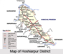
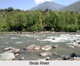
 Hoshiarpur District is located in the north-east part of Punjab. It falls in the Jalandhar Revenue Division and is situated in Doaba region of the state. The district is sub-mountainous and stretches of river Beas in the north-west. Hoshiarpur District lies between north latitude 30 degree 9 minutes and 32 degree 5 minutes and east longitude 75 degree 32 minutes and 76 degree 12 minutes. This administrative district of Punjab shares common boundary with Kangra and Una districts of Himachal Pradesh in the north east, with Jalandhar and Kapurthala districts (interspersed) in south-west and Gurdaspur district in the north-west. Hoshiarpur is the district headquarters.
Total area occupied by Hoshiarpur District is 3,365 sq kms. As per 2001 Census, total population of the district is 14, 78,045, of which male population is 7, 63,753 and female population is 7, 14,292. Density of population is 439 per sq km. Major fruits grown in Hoshiarpur District are mango, peach, litchi, pear, guava, etc. and among the vegetables Potato has the major share followed by peas.
History of Hoshiarpur District
The history of Hoshiarpur District describes that this region formerly formed parts of Katoch in Jalandhar. It was a part of Indus Valley Civilization. As per the medieval history of Hoshiarpur District, the entire region from Sutlej River to Beas River had come under Lahore government by the end of 1818. In the year 1846 after the First Anglo-Sikh War, it passed under the British government. History of Hoshiarpur District also states that it played a big role in the freedom movement of the country.
 Geography of Hoshiarpur District
Hoshiarpur District has mild climate compared to other districts of the state. This is due to the abundance of hilly terrain on one hand and sizeable forest covers the other. Moreover, dams constructed under `Kandi Watershed Development Project` have enhanced the water surface area in the district. This feature has made the summer season quite pleasant. The pattern of seasons in Hoshiarpur District is similar to other districts of the state, except slight variations at the terminals and year may be divided into three main seasons. The summer season sets in April and lasts up to end of June, to be taken over by the rainy season when it becomes hot and sultry. The rainy season sets in the beginning of July and lasts up to September end. The winter season starts from October and lasts up to March end. May and June are the hottest months when mercury level crosses around 45 degree Celsius on some days. The months of December, January and February are the months when winter is quite severe and mercury comes down to around 5 degree Celsius.
Annual average rain in the district is 1125 mm. 75 percent of the rainfall is experienced in the period July to September, whereas 15 percent rainfall is experienced in the winter months of January and February.
Administration of Hoshiarpur District
Administration of Hoshiarpur District comprises four Sub-Divisions, ten Development Blocks, eight Municipal Councils and one Notified Area Committee. The four sub-divisions are Hoshiarpur, Dasuya, Mukerian and Garhshankar. There are ten development blocks namely Hoshiarpur-I, Hoshiarpur-II, Bhunga, Tanda, Dasuya, Mukerian, Talwara, Hajipur, Mahilpur and Garhshankar. The eight municipal councils are Hoshiarpur, Hariana, Tanda, Dasuya, Mukerian, Garhdiwala, Sham Chaurasi and Garhshankar. The one notified area committee of the administrative set-up of Hoshiarpur District is Mahilpur.
Education in Hoshiarpur District
Hoshiarpur District has a long tradition of educational attainments. The D.A.V. and Singh Sabha movements resulted in establishments of many educational institutions. On the eve of partition, Punjab University, Lahore was shifted to Govt. College, Hoshiarpur and remained there till the early sixties when it was shifted to Chandigarh. As a result of this, the district has many luminaries in various fields of society. Total number of educational institutes in the district is around 1727.


