 History of West Kameng district includes the administrative changes that ultimately lead to the formation of this district. The area around the Kameng River had traditionally come under the control of the Mon kingdom, Bhutan, Tibet and the Ahom kingdom. The name of the West Kameng district of Arunachal Pradesh was derived from the Kameng River, a tributary of Brahmaputra River that flows through this district. Under a notification of 1914 by the Government of India, the area covered by this district, became a part of the `Western Section` of the `North East Frontier Tract` to which the entry of the British subject was regulated by an `Inner Line`.
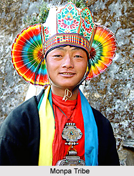
Further, like other parts of North East Frontier Agency (NEFA), this district was also under the Ministry of External Affairs and a political officer was over all in-charge of the district. Later on Kameng Frontier Division was renamed as `Kameng District` and the Political Officer was re-designated as `Deputy Commissioner`. However, because of some political reasons, the Kameng district was bifurcated between East Kameng district and West Kameng district on the 1st of June, 1980. East Kameng District was formed, covering the area of the Seppa subdivision. Tawang, which initially belonged to part of the district, was separated on 6th of October, 1984. Small, feudal chiefdoms ruled by the kings of Monpa tribe and Sherdukpen tribe exerted control over the area from time to time. The evidence can be witnessed through ruined fortresses like those in Bhalukpong and the Dirang fort were constructed to defend against invasions from adjoining kingdoms.
The historical accounts of West Kameng district also reveals that upon the coming of the British, the entire area came to be known as the North-East Frontier Agency. It was again renamed as the Balipara Frontier tract in the year 1919, with its headquarters at Charduar in Assam. In the year 1946, the West Kameng district area was carved out of the Balipara, with the name Sela Sub-Agency and its headquarters remained at Charduar without any changes. After the independence of the country, again in the year 1954, Sela Sub-Agency was renamed as the `Kameng Frontier Division` and its headquarters was later shifted to Bomdila. However, with the invasion of Tibet in the year 1950 the influx of `Tibetan Refugees` started in the area and furthermore, with the invasion of the Chinese troops into this region many historical monuments were either destroyed or defaced. The Kameng Frontier Division was later renamed as the Kameng District. The Political Officer was also re-designated as the Deputy Commissioner of this district.


