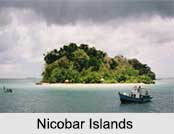
 History of Nicobar Islands is the same as related earlier of the Andaman Islands. The Nicobar Islands are said to have been occupied for thousands of years. Different empires like the Chola Empire, Europeans, Danes, British and Japanese all have colonized the Nicobar Islands. During the World War II, the islands were occupied by Japanese in between 1942 to 1945. India occupied these islands after the surrender of Japanese as their Territory.
Naming of Nicobar Islands
The initial existing references of the name "Nicobar" is in the Sri Lankan Pali (Indo-Aryan Language) Buddhist chronicles, the "Dipavamsa" and the "Mahavamsa" which state that the children of the followers of the legendary founder of the Sri Lankan Kingdom, Vijaya, landed on "Naggadipa" (the island of the children). The contemporary name is derived from the Chola dynasty name for the islands, "Nakkavaram" or `Puup Pii` which literally means the "naked man" in Tamil language which is inscribed in the Thanjavur (Tanjore) writings of 1050 CE.
Colonization of Chola Over Nicobar Islands
Nicobar Islands are believed to have been incorporated with the invasions of King Rajendra Chola I in the 11th century AD. The complete archipelago was named "Nakkavaram" but the islands of the Great Nicobar and Car Nicobar were correspondingly called "Nagadweepa" and "Karadweepa". Nicobar also come out as "Nakkavaram" in the Tanjore writings of 1050 AD while some Arab traders have also called them "Lankahbalus" meaning the land of the naked people.
Colonisation of Europeans Over Nicobar Islands
After the Chola Empire, during the 15th and 16th centuries, Portuguese missionaries were propagating the nearest archipelago of Nicobar and made several attempts to evangelize the people of the Nicobar Islands but they could not make it at first. During reign of Queen Elizabeth I, the Swedish navigator, Koeping reached these islands in a Dutch ship and thought the hanging restraint of the cloth worn by the natives, as anatomical tails. The Jesuit missionaries were the earliest to arrive at the Car Nicobar Island in 1711 AD to convert the natives of the Nicobar Islands to Christianity.
 In 1756 AD, the Dutch Government took over the Nicobar Islands for colonizing. They founded the colony on the north coast of the Great Nicobar and afterwards transferred it to the Camorta Island. Some of the Danish missionaries also later on reached here to evangelize the Nicobarese. However, the Danes had to leave from the complete project yet again because of the harmful climate. However, two of them founded a Danish Missionary. The Austrian Government also tried to inhabit these islands and with the aim they built a fortress on Camorta Island in 1788 AD though, they had to withdraw it because of the protesting of the Danes.
Italy made an attempt at buying the Nicobar Islands from Denmark between 1864 and 1868. The Italian Minister of Agriculture and Commerce Luigi Torelli started a concession that looked promising but failed due to the unexpected end of his Office. In the early 19th century, the French and Italian Jesuits missionaries also made unproductive attempts at evangelizing the Nicobarese. After two more failures to inhabit these islands, the Danes left the Nicobar Island in the year of 1849.
Colonization of British Over Nicobar Islands
The abandoned Nicobarese after 1849 became disreputable for slaying the visiting crews of passing ships after the Danes left. As many as 26 vessels were detained and damaged by the Nicobarese. In the year 1866, the ship Futteh Islam was attacked at the Great Nicobar and 21 members of the crew were slain.
To check their evil activities, the British thought of taking over these islands. They discussed with the Danish Government who still maintained the official dominion over these islands. After the interventions, the Danes handed over the official controls to the British in 1869. Britishers were interested in building a severe settlement on the pattern of Port Blair. In the year 1884, an ineffective attempt had been made for setting up a colony by the Chinese traders also. The missionaries also introduced cows and some better species of pigs here. The system of wood fencing is also said to be the involvement of the Moravian missionaries. British were not interested in making any sophisticated managerial arrangements for these islands therefore the Nicobar Islands were attached to the Andaman Islands.
British authorities used to appoint an agent, stationed in the Car Nicobar islands. His main task was to maintain a connection between the islanders and the British authorities as well as to maintain the law and order. One such agent was Vedappan Solomon, an intelligent and clever Indian Christian, who became the agent in 1895 of the village Mus of the Car Nicobar Island. He set up the first Anglican Church that is the Saint Thomas Church in India.
Vedappan Soloman and his wife started a school where they admitted the promising boys as students. These students were generally from the powerful families of the village headmen. One such boy was, John Richardson, who showed the signs of leadership with remarkable academic prowess. After completing his education, John Richardson returned to the Car Nicobar and started working in the Mission School as a teacher and Catechist.
Colonisation of Japanese Over Nicobar Islands
The occupation of the Andaman and Nicobar islands by the Japanese gave a new turn to the history of Nicobar Islands. It was the Japanese forces who started to torture the natives for the first time. The Japanese not only exacted physical tortures on the Nicobarese but also attacked the nexus of their financial system. The only fault of the Car Nicobarese was that a majority of them were Christian and some of them knew Hindustani and English. They were believed to be the spies of the British India authorities and thus were tortured in several ways. At that time, there were nearly 400 Christians on this island out of this number 104 were killed. Many of the members of the family of John Richardson were also killed. John Richardson led his people with bravery, strength, and persistence. The present scenario of the Car Nicobar Island is essentially due to the praiseworthy work rendered by John Richardson. John Richardson was elevated to Bishop-hood by the Church for his meritorious missionary services. Similarly the President of India nominated him as a Member of Parliament in recognition of his self-sacrificing service rendered to the people of these remote and isolated islands.
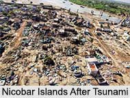
On 26th December 2004, the coast of the Nicobar Islands was devastated by a 10-15 meters high tsunami following the 2004 Indian Ocean earthquake. At least 6,000 people were killed on the Andaman and Nicobar Islands and several were greatly damaged by the islands broken in two or three pieces. Teressa Island was said to have been split into two pieces and Trinkat Island into three pieces. On 31st May 2013 it was reported that Nicobar Islands have been declared as World Biosphere Reserve by UNESCO.


