 History of Dhosi Hill is evident from that fact that Dhosi Hill was directly linked to the birth and growth of the `Sanatana Dharma` or `Vedic Sanskriti` in the form of `Manusmriti`. Dhosi Hills, which is located on the north-western part of Aravalli Mountains, covering the northern part of Rajasthan and southern portion of Haryana is ancient volcanic eruption site, wherein a volcano erupted at the start of `Treta Yuga`, as explained by Guru Shashank who had walked along with the Pandavas in their exile or `Agyaatwas`, over 5100 years ago. This area was populated by many `Rishi` and `Muni` in ancient times and even today solidified lava can be observed on the hill slopes.
Dhosi Hill is revered as a great Ayurvedic centre since the ages of the Vedas due to the existence of virgin and fertile soil, which helps the growth of various unique Indian herbs here. The world famous Ayurvedic solution named `Chyawanprash` was manufactured at Dhosi Hill by royal vaids, by combining 46 herbs, to offer respite to Chyavana Rishi who was suffering from skin diseases. It is said that Chyavana Rishi started appearing refreshed and much younger after he consumed this magical herbal solution. Chyavanprash is quite sought after even today for its rare medicinal properties. Not only is it popular in India but is also quite popular in the overseas market.
Dhosi Hill is also the source of the renowned `Kayakalp` which is an effectual natural treatment that helps the human skin to emerge fresher and much younger. This had made Chyavana Rishi attain a youthful look and the tale has been described vividly in the Puranas, Brahmanas and also the Mahabharata. The procedure of this process was invented by the Ashwini brothers who utilized several herbs to make it possible. Vedic books contain references of the process of Kayakalp and the water of the pond located at the top of Dhosi Hill is considered to be a rejuvenating and purifying agent even today. Pilgrims from different parts of the country pay visit to this pond to take a dip in its waters which is said to possess traces of copper and dissolved herbs. Water rich in copper content is believed to work wonders for digestion, eyes and also the skin.
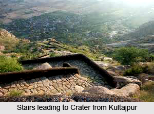
King Hem Chandra Vikramaditya, also known as Hemu had established a fort in Dhosi Hill about 500 years ago, whose ruins can be seen today. It is heavily fortified with thick walls which reach till a height of 25 feet and are as much as 40 feet in width.


