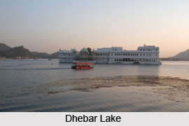
 Dhebar Lake which is also known as Jaisamand Lake is the artificial lake in Udaipur of Rajasthan. Known as Asia`s second-largest artificial lake is almost dried up due to lack of rainfall in summer months.
Jaisamand Lake is located in the Udaipur District of Rajasthan state in western India. It has an area of 87 square kilometres and was created in the medieval times. In the17th Century, when Rana Jai Singh of Udaipur built a marble dam across the Gomati River, this lake was formed in the midst of the dense jungle which is known as Jaisamand Sanctuary.
Dhebar Lake or Jaisamand Lake was built by Maharana Jai Singh in the year 1685. It is the second biggest artificial lake in the world covering an area of 36 square miles. The lake remained the largest artificial lake in the world till the building of the Aswan dam in Egypt by the British in 1902. That dam of artificial lake was reconstructed between 1960 and 1970.
During the reign of Maharana Jai Singh (1680-1698), there was a great need for water for cultivation in south eastern corner of Mewar. For this reason, Dhebar Lake or Jaisamand Lake was created. Maharana Jai Singh emulated his father, Maharana Raj Singh I who built Rajsamand Lake by damming a small river of Udaipur- the Gomati River. At that time it was built as a massive embankment. The height of the dam is 36.6 meters. Jai Singh named the lake as Jaisamand after himself - its often-used nickname is `Ocean of Victory`.
On the day of its inauguration, June 2, 1691, Maharana Jai Singh walked around the dam charitably distributing gold equal to his own weight. The statistics of the lake is really amazing - 9 miles in breadth, 102 feet deep at its deepest end, a circumference of 30 miles, with marble staircases leading into the water. The summer palaces of the Queens of Udaipur surround Dhebar Lake on all sides.
There are 3 islands on Dhebar Lake, and the tribe of Bhil Minas are residing at that place from the early times. There are two bigger islands known as Baba ka Magra and the smaller island is called Piari. Dhebar Lake or Jaisamand Lake has elegant steps leading to the water and marble Chhatri, which is known as cenotaphs on its bank with a small Shiva temple that marks the grace of the lake.
Dhebar Lake or Jaisamand Lake is encircled by hills and with a number of summer palaces along the shore. The lake is a natural and peaceful heaven for the birds and animals. There are eleven islands on the lake, some of which provide sanctuary inhabited by several species of migratory birds. Maharana Jai Singh at the time of digging the foundation for Dhebar Lake or Jaisamand Lake celebrated the occasion by giving away gold in charity after a "Tuladaan Ceremony". In Dhebar Lake or Jaisamand Lake there are three islands whose inhabitants use boats to reach the shore. On the top of two nearby hillocks are two old palaces constructed by Maharana Jai Singh still existing in good condition.
A trip to Jaisamand Wildlife Sanctuary near Dhebar Lake or Jaisamand Lake allows a close encounter with the rich wildlife in their natural habitat. The fauna includes panther, wild boar, deer, four-horned antelope, mongoose and various species of migratory birds.
Jaisamand Lake is 45 km from District headquarters of Udaipur. When it was built, it was the largest artificial lake in the world. The surrounding Jaisamand Wildlife Sanctuary around Dhebar Lake or Jaisamand Lake can be reached by the state highway to Baswara from Udaipur.


