 Early history of Bilaspur District claims its descent from Chandervanshi Rajputs who reigned at Chanderi in Bundelkhand region of Madhya Pradesh. The place now forms part of Guna District. It is said that the seventh ruler of Chanderi Kingdom Harihar Chand had a dream of Goddess Jawalamukhi. Thereafter, he decided to seek his fortune in a shrine. As a result of this, he handed over the kingdom to his youngest son Govind and then proceeded towards Jawalamukhi along with his other four sons and established at Jindbari where they constructed a fort and settled there for some time before proceeding to Jawalamukhi. They also paid a visit to Nadaun, the then capital of Kangra. One of his four sons was killed in a battle against the Kangra forces.
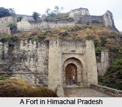
Further, as per the history of Bilaspur District the three Chanderi princes reached Jawalamukhi shrine. The reigning Goddess appeared and promised each of them a kingdom. In the fulfillment of her prophecy one of the three princes was adopted by the Raja of Kumaon and other prince Gambhir Chand took possession of Chamba and the eldest son Bir Chand got Jindbari (at present in tehsil Anandpur Sahib in Rupnagar District of Punjab). It was Bir Chand who constructed the Naina Devi temple. He extended the Jurisdiction of his kingdom Kahlur during his 33 years of rule and conquered about 15 neighbouring princely states. His ambition of extending jurisdiction was ultimately halted by the Raja of Sirmaur with whom he concluded treaty of peace. Thus, he carved out a kingdom of Kahlur for himself. Bir Chand was followed by a number of his successors and last of them was Kahan Chand who conquered Nalagarh and gave it to his second son Surjeet Chand from whom the present ruling family of Nalagarh descends.
According to historical accounts, the capital of ruling dynasty continued to be located at Kotkahlur till 1600 AD. In 1650 A.D. when Deep Chand of the same dynasty succeeded as Raja of Kahlur state, he decided to shift his capital as he developed strong disliking for the place. Since that time the capital of Bilaspur continued to be at Bilaspur though the original town which was established by Chandel dynasty was submerged in the `Govind Sagar` on 1st of July, 1954. A new township above the old one has come up at an elevation of 673 metres above sea level.
History of Bilaspur District in the post independence era states that Himachal Pradesh came into being as a part of the states of the Indian Union on 15th of April, 1948. It was formed as result of merger of 30 Punjab and Shimla Hill states in the Indian Union namely Baghat, Bhajji, Baghal, Beja, Balson, Koti, Kumarsain, Kunihar, Kuthar, Mandi, Bushahr, Chamba, Darkoti, Delath, Dhadi, Dhami, Ghund, Jubbal, Khaneti, Keonthl, Madhan, Mahlog, Mangal, Ratesh, Rawringarh, Sangri, Sirmaur, Suket, Tharoach and Theog. At that time the state had four districts namely Chamba, Mahasu, Mandi, Sirmaur and its area was 2,716,850 hectares. The state was taken over under the Central administration on 12th of October, 1948.
Further, by an act of Parliament the 31st state of Bilaspur which was till then a separate entity under the control of Chief Commissioner, was integrated with Himachal Pradesh on 1st July, 1954 thereby adding one more district with an area of 106,848 hectares. Initially, it consisted of two tehsils namely, Ghumarwin and Bilaspur Sadar. In January, 1980 the state government created a separate sub-tehsil called Naina Devi with headquarters at Swarghat out of Bilaspur Sadar Tehsil. In 1984, one new sub-tehsil namely, Jhandutta was created by carving out some areas of tehsil Ghumarwin. Jhandutta sub-tehsil was given the status of a full tehsil in January, 1998. Administratively, the district is divided into two sub-divisions, three tehsils, and one sub tehsil, three community development blocks, 136 Panchayats, two municipal committees and two notified area committees.


