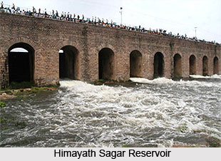
 Himayat Sagar is an artificial lake or man made lake in Telangana. This lake is located at about 20 km from Hyderabad, the capital city of both Andhra Pradesh and Telangana. Himayat Sagar lies parallel to a larger artificial lake Osman Sagar, another artificial lake that was built during the early rule of Nizams of Andhra Pradesh. The storage capacity of Himayat Sagar reservoir is about 3.0 TMC.
Himayat Sagar is the water source for irrigation in both the states of Telangana and Andhra Pradesh. This lake also serves a major tourist spot in Hyderabad City, the capital city of both Telangana and Andhra Pradesh for 10 years.
Himayat Sagar is situated at a distance of twenty kilometres from Hyderabad. This reservoir on the Musi River was finished in 1927.
Himayat Sagar lies parallel to the Osman Sagar Lake. The lake was named after the youngest son of the seventh Nizam, Himayat Ali Khan. These two lakes are now acting as an ideal picnic spot and the weekend tourist destination in Hyderabad.
The grassy area of Himayat Sagar is bordering the lake enhancing the beauty of the lake. Himayat Sagar along with the Osman Sagar provides drinking water and also water for irrigation to the twin cities of Hyderabad and Secunderabad. Secunderabad is popularly known as the twin city of Hyderabad is located in Telangana. This city is named after Sikandar Jah, the third Nizam of the Asaf Jahi dynasty. Secunderabad was founded in the year 1806 as a British cantonment during the rule of British Government in India.
The construction of Himayat Sagar happened on Esi River, a tributary of Musi River. The construction of this lake was completed in the year 1927. Himayat Sagar at that time provided drinking water for Hyderabad and saved the city from floods, which Hyderabad suffered in 1908. Himayat Sagar was built during the reign of the last Nizam of Hyderabad, Nizam VII and so it is named after his youngest son Himayat Ali Khan.
Himayat Sagar and Osman Sagar reservoirs provided continuous water supply to the twin cities of Hyderabad and Secunderabad until recently. Due to population growth in both the cities of Telangana it was not sufficient for water supply to Hyderabad city. The engineer at the time of construction was late Khaja Mohinuddin, the son of Mohammed Hussein, Madri. In June 2012, the water level at Osman Sagar was 1769.8 feet. On October 1, 2012, the level was 1771.8 feet, an increase of a mere 2 feet. Similarly, in Himayat Sagar, the water level in June 2012 was 1743.3 feet and on October 1, it was raised up to 1,747.4 feet. There is an increase of about 4 feet in the water of Himayat Sagar. In October 2011, the water levels at Osman Sagar and Himayat Sagar were 1781.9 feet and 1754.9 feet respectively.
Himayat Sagar is a really good reproduction area for marsh birds of Hyderabad and that too very close to the suburban area of Hyderabad.


