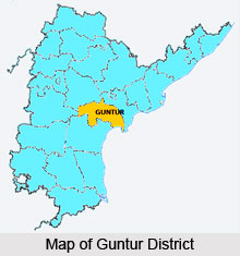
 Guntur District is situated in the state of Andhra Pradesh beside the east coast of Bay of Bengal. The coastline of the district is almost 100 km. The city of Guntur is the administrative hub and the largest city in Guntur District. The district is renowned as a foremost learning center. In the year 1970, a portion of Guntur district was segregated to become part of Prakasam district. Guntur district is presently a part of the Red Corridor. Guntur district is deeply rooted in history and comprises of several temples that are scattered through out the district.
History of Guntur District
It is considered that Agastya built the Agasthyeswara Sivalayam, a Shiva temple, during the Treta-Yuga. There are inscriptions Naga Lipi that date back to around 1100 CE. The caves of Guthikonda and Sitanagaram are calculated to be form around the Treta-Yuga and Dwapara-Yuga. The Sala kings ruled the region from 5th century BCE. There are references of Guntur in the Idern plates of the Vengi Chalukyan King, Ammaraja I (922-929 CE). Guntur district also finds mention in 2 other inscriptions that are dated around 1147 and 1158 CE. Gautama Buddha preached at Dhanyakatakam, which is near Guntur and organized the Kalachakra ceremony during 500 BCE.
In the ancient times, buddhists founded universities Dhanyakatakam and Amaravathi. In the villages of Guntur district numerous Buddist stupas were excavated. Hiuen Tsang, a Chinese traveler, observed and wrote magnificent accounts of many Viharas in Amaravathi during 640 C.E. But some of them were abandoned, as Hinduism was gaining popularity. During ancient and medieval periods, Guntur district was sequentially ruled by various dynasties like Andhra Ikshvakus, Vishnukundina, Satavahanas, Chalukyas, Pallavas, Vijayanagara, Ananda Gotrikas, Kakatiyas, Cholas and Qutb Shahis. The battle of Palnadu was fought in Guntur district around 1180 CE.
During 1687 CE, Mughal emperor Aurangzeb defeated the Qutb Shahi sultanate of Golconda and conquered Guntur. By 1788, Guntur district came under the rule of the British East India Company and was included in the Madras Presidency. Guntur district played a noteworthy role during the Indian freedom struggle and the formation of the state of Andhra Pradesh.
 Geography of Guntur District
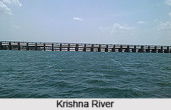
Guntur district consists of a total area of around 11,400 sq km. The Krishna River flows through the district and comprises the northeastern and eastern border of Guntur district, separating it from Krishna District. The district is bordered by the Bay of Bengal on the southeast, by Prakasam District on the south, by Mahbubnagar District on the west, and by Nalgonda District on the northwest.
Demography of Guntur District
As per the 2011 census, Guntur district consists of a population of 4,889,230 and is ranked at 22 out of 640, in India. The population density is 429 inhabitants per sq km and population growth rate during 2001-2011 was 9.5 %. The gender ration of Guntur district is 1003 females for every 1000 males. The literacy rate is 68% in Guntur.
Administration of Guntur District
Guntur district is divided into 3 revenue divisions, Guntur, Narasaraopet and Tenali. The district is further divided into 57 mandals for better administration and supervision. The various mandals include Achampeta, Amaravathi,Bellamkonda, Bollapalle, Cherukupalle, Chilakaluripet, Duggirala, Durgi, Edlapadu, Gurazala, Ipuru, Karempudi, Kollipara, Krosuru, Macherla, Medikonduru, Nadendla, Nagaram, Narasaraopet, Pedakakani, pedanandipadu, Pittalavanipalem, Rajupalem, Rompicherla, Sattenapalli, Tadikonda,Tenali, Tsunduru, Veldurthy, Vinukonda and others.
Culture of Guntur District
The main language of Guntur district is Telugu which is spoken widely. Urdu is the second official language of the district. The festival of Shivaratri is grandly celebrated in Guntur district.
Education of Guntur District
There are many premiere institutions in Guntur district like Guntur Medical College, NRI Medical College, Katuri Medical College, RVR and JC College of Engineering, Vignan University, Bhashyam Group of Institutions, Acharya Nagarjuna University, Andhra Christian College, Hindu College etc. There are 2 deemed universities in Guntur district, K L University and Vignan University.
 Economy of Guntur District
Agriculture is the main occupation of the people of Guntur district. Tobaccos, Paddy, Chillies, Cotton etc. are some of the major cultivated products in the region.
Tourism of Guntur District
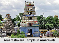
Guntur District is mostly known for its historical and religious significance. The most popular places here are Amaravathi, Bhattiprolu, Ponnur, Kotappakonda, Gurazala, Kondavid fort, Vinukonda, Undavalli caves, Macherla, Tenali and the Guntur archeological museum. The Amareshwara temple in Amaravati is popular for the Shiva temple. The 3 mountain peaks known as Brahma, Vishnu and Rudra peaks in Kotappakonda, are also popular amongst the visitors.
There are many renowned temples in Guntur District such as Bhavanarayanaswamy temples at Bapatla and Ponnuru, Nadivelamma temple and Lord Shiva Temple in Rajavolu, Koteswara Swamy temple in Govada village in Amritalur Mandal, Sri Venkateswara Swamy temple in Thullur mandal, Abhayanjaneya statue and Venugopalaswamy temple in Pedaparimi village. The Sri Sringeri Math in Sampath Nagar comprises of several temples in the complex. Mangalagiri is also well known as a Temple town in Guntur District. Numerous devotees also visit the Lakshmim Narayana Svami Temple in Sampath Nagar.
Ettipotala Jalapatam Waterfall located near Nagarjuna Sagar Project also attracts many tourists from across the country.


