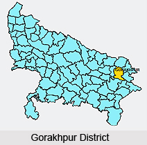
 Gorakhpur District is one of the administrative districts of Uttar Pradesh. Gorakhpur is the headquarters of Gorakhpur Division and the district. Gorakhpur District is located at around 265 kms east of Lucknow. Gorakhpur District lies between latitude 26 degree 46 minutes north and longitude 83 degree 22 minutes east, covers the geographical area of 3483.8 sq kms. This district is bounded by districts Mahrajganj in the north, Ambedkar Nagar District, Azamgarh District and Mau District in the south, Kushinagar and Deoria District in the east and Sant Kabir Nagar District in the west. Total population of Gorakhpur district as per 2001 Census is 3769456, of which male population is 1923197 and female population is 1846259.
History of Gorakhpur District
Gorakhpur District derived its name from the name of Saint Gorakshnath, profounder of `Nath Sampradaya`. According to early history, Gorakhpur District formed a part of Koshal Kingdom, one of the sixteen mahajanapadas. Further, it formed a significant part of several dynasties like Maurya Empire, Shunga Dynasty, Kushana Empire, Gupta and Harsha dynasties. Muhammad Ghori also ruled the region. In the year 1801, it was transferred under the control of East India Company and then it was given the status of a separate district. Gorakhpur became the headquarters of Gorakhpur Division in the year 1829.
 Administration of Gorakhpur District
Gorakhpur division comprises four districts, Gorakhpur, Deoria, Mahrajganj and Kushinagar. As a basic administration unit Gorakhpur District, has assumed a greater development and regulatory role consequent to emphasis on decentralized planning. Administration of Gorakhpur District is divided into seven Tehsils (Revenue Sub- Divisions) presided over by a Sub Divisional Magistrate. Tehsils are further sub-divided into 19 Development Blocks, Blocks into 191 Panchayats and these Panchayats into 1233 Gram Sabhas which consists of 3319 Revenue villages. The seven tehsils of Gorakhpur District are Sadar, Chauri Chaura, Chauri Chaura, Sahjanwa, Khajni, Campierganj, Bansgaon and Gola. The 19 development blocks of the administrative set-up of Gorakhpur District are Jungle Kauria, Charganwa, Bhathat, Khorabar, Pipraich, Sardar Nagar, Brahmpur, Sahjanwa, Pali, Piprauli, Khajni, Belghat, Campierganj, Bansgaon, Kauriram, Gagaha, Gola, Barhalganj and Uruva.
Education in Gorakhpur District
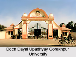
In Gorakhpur District, education as an integral part of development of human resources has received an impetus with the establishment of the Deen Dayal Upadhyay Gorakhpur University. Progress in educational sphere has been impressive over the years in this district. Gorakhpur has residential University, Engineering College, Medical College, several degree colleges and schools.
Gorakhpur District is well connected with all major cities of the state. Frequent road-transport is available for all major cities of Uttar Pradesh. Air Force Station is 8 kms from the railway station. Daily flights are available from Gorakhpur to Delhi and Kolkata via Lucknow.


