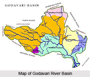
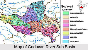
 The Godavari River has ample tributaries and distributaries that flow in the Godavari River Basin. Some of the main rivers flowing in the Godavari river basin are as follows -
After the Ganges and the Indus Rivers the Godavari River is a sacrosanct river in India. It originates in the Western Ghats near Trimbak in Nashik district of Maharashtra. It then flows in the east across the Deccan Plateau traversing through the states of Maharashtra and Andhra Pradesh. It flows in a southeastern direction in order to evacuate in the Bay of Bengal through two mouths. The major tributaries of the Godavari are Indravati River, Manjira River, Bindusara River and Sabari River. It travels a distance of 1,465 km. before draining into the Bay of Bengal.
The Kolab River is the tributary of River Godavari and flows in the Koraput districts. The Kolab originates from the Sinkaran hills of the Eastern Ghats in Koraput districts. The river covers a catchment area of 20400 sq. kms. The Gupteswar Temple is an important pilgrimage along the river. The Indravati River is a tributary of the Godavari River, located in central India. The river rises in the Eastern Ghats in Orissa and flows westwards to join the Godavari, thus forming the boundary between Maharashtra and Chhatisgarh states at some places. Most of the River Course of Indravati is through dense forests of Bastar. The famous `Chitrakoot` falls forms on Indravati River, some 40 km from Jagdalpur in Chhatisgarh.
The Bandiya River is a tributary of Godavari, flowing in Gadchiroli district of Maharashtra. Pranhita River flows on the edge of Gadchiroli district in Maharashtra and Adilabad district in Andhra Pradesh. The name Pranhita is derived from the nature of combined flow of the rivers Painganga and Wainganga. The Wainganga river originates about 12 Km from Mundara village of Seoni district in the southern slopes of the Satpura Range of Madhya Pradesh, and flows south through Madhya Pradesh and Maharashtra in a very meandering course of roughly 360 miles.
Sati River is one of tributaries of Godavari River and flows in the district of Gadhchirli. Khbragadi River is one of tributaries of Godavari River. Chulband River is one of tributaries of Godavari river. Other than the Kanhan River, the Pench, Jam, Kulbehra, Shakkar and Doodh rivers also flow in the region of Sausar in Madhya Pradesh. Kanhan river flows in the Southern direction through the western parts of Chhindwara Tahsil and converges with the Wenganga river.
Nag River is a tributary of Godavari River. The Pench River is a tributary of Godavari river and flows in the border areas of Chhindwara and Seoni Districts in Maharashtra. Kolhar River is one of tributaries of River Godavari, flowing in Nagpur. The Sur River is a tributary of Godavari River and flows in the districts of Bhandara and Nagpur in Maharashtra. Bawanthadi River starts it journey from the Kurai plateau of Seoni District in Madhya Pradesh. Eventually, the river enters Bhandara District of Maharashtra by flowing towards south and functions as an interstate boundary between two states all along its middle course.
The Wagh River is also known as the Daman Ganga River in Goa.
 The Wardha River is the distributary of Godavari and a significant tributary of Pranhita River. The Penganga River is also known as the Painganga River and is considered as the chief river of the Yavatmal district in the Maharashtra state in India. Geographically Vidarbha lies on the northern part of Deccan Plateau and the Vidarbha River lies in this hilly terrain. Arunavati River is one of the chief tributaries of Penganga River. The river flows across Darwha and certain areas of Kelapur.
A principal tributary of the Painganga River, the Adan river flows in the state of Maharashtra. The Adan River originates in the Washim district of Maharashtra (India) and flows across a curve, north, east and south, and finally converges with the Painganga River. The river Kayadhu on entering the district from the northwest turns at a right angle flows northeastwards under the influence of a similar turn of the spur and joins the Penganga. The Vena River play a vital role in agriculture of Nagpur. The crops grown in the territory have a strong bearing on this river.
Bor River is one of the tributaries of Godavari River in India. Yashoda River is one of the tributaries of Godavari River in India. Dham River is one of the tributaries of Godavari River in India. Bhakalee River is one of the tributaries of Godavari River in India. Ramganga River is the most important factor for the maintenance of Jim Corbett Park. In fact without this river, there would be no Corbett Park established. This river is the tributary of Godavari and the largest of the precious few persistent sources of water in the Park.
The start of the Bombala River is in the Brown Mountain area with other rivers emptying into it. Charghad River, Maad River, Manjra River, Manhaad River, Lendi River and Terna River are some of the tributaries of Godavari River flowing in India. The Tavarja River is a tributary of Godavari and flows through the Latur district of Maharashtra. The Kelna River flows in the administrative district of the Indian state of Maharashtra. Bindusara River is one of the tributaries of Godavari River in India.
The Karanja river is a distributary of Godavari River with mythological importance. The location of Karanja River co ordinates latitude 18degree 4` 60 N and longitude 77degree 4` 60 E. Karanja river basin covers around 2422 square kilometers. Devani River is one of the tributaries of Godavari River in India. The Kadakpurna River flows through the district of Parbhani, which was previously known as Prabhavatinagar. This river plays a significant role in the lifestyle of the people residing in this region. The Dudhna River flows in the district of Parbhani, which lies in the east central part of Maharashtra. The river flows parallel to the Hyderabad railway line that is about 16 km south of the Dudhna River.
The Kapra River flows in the hydrographic soil, through the state of Maharashtra. This tributary of Godavari river coordinates from the latitude 19degree 22` 60 N to longitude 76degree 54` 0 E. Kham River is one of the tributaries of Godavari River in India. Shivna River is an important tributary of Godavari, flowing in the state of Rajasthan. In old maps this river is written as SAU and SEU. Pravara River is an important river in the western parts of Maharashtra. It is one of the main tributaries of the Godavari River. The Mula river is an important river in India that originates at the Mulshi Dam in Taluka Mulshi in Pune district in the Western Ghats province of the Indian state Maharashtra.
Kadwa river is one the most important tributaries of Godavari River. The Nandur Madhmeshwar Dam lies at the convergence point of Godavari and Kadwa Rivers. The Darna River rises from the highlands of the Sahyadris; it is one of the major tributaries of Godavari. The Darna River flows through an area of hydrographic soil.


