Home > Indian History > Geography of India > Geological History of India
Geological History of India
Geological history of India dates back to billion of years and presently India has a diverse geology.

Share this Article:

Geological History of IndiaGeological history of India started with the geological evolution of rest of the Earth i.e. 4.57 billion years ago. India has a diverse geology. Different regions in India feature rocks of all types belonging to different geologic periods.

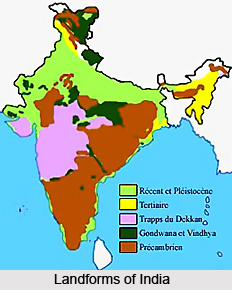
Some of the rocks in India that are quite significant geologically are deformed and transmuted while others are recently deposited alluvium that have yet to undergo diagnosis. Mineral deposits of high variety are found in the subcontinent in huge quantity. Even the fossil records are impressive in which stromatolites, invertebrates, vertebrates and plant fossils are included. India`s geographical land area is classified into Deccan Trap, Gondwana and Vindhyan.

Deccan Trap is one of the most vital geological patches of India. Firstly, the Deccan Trap covers almost all of Maharashtra, a part of Gujarat, Karnataka, Madhya Pradesh and Andhra Pradesh marginally. It is believed that the Deccan Trap was formed as result of sub-aerial volcanic activity associated with the continental deviation in this part of the Earth during the Mesozoic era. That is why the rocks found in this region are generally igneous type. During the northward movements of the geological blocks after breaking off from the rest of Gondwana, the Indian Plate passed over a geologic hotspot, the Réunion hotspot, which caused widespread melting below the Indian craton. The melting broke through the surface of the craton in a massive flood basalt event, creating what is known as the Deccan Traps. It is also thought that the Reunion hotspot has resulted in the separation of Madagascar and India.
Geological History of India
The Gondwana and Vindhyan region include within its fold parts of the present states like Madhya Pradesh, Chhattisgarh, Orissa, Bihar, West Bengal, Andhra Pradesh, Maharashtra, Jammu and Kashmir, Punjab, Himachal Pradesh, Rajasthan and Uttaranchal. The Gondwana Supergroup forms a unique sequence of fluviatile rocks deposited in Permo-Carboniferous time. Damodar and Son river valley and Rajmahal hills in the eastern India is depository of the Gondwana rocks. The geological society of India has immense research works on the geological history of India. This society was established on 28th May, 1958, to promote the cause of advanced studies and research in all branches of Earth Systems Science. The Journal of the society is the flagship publication, which publishes peer-reviewed articles under the category of Review Papers, Research Papers, Notes, Short Communications, Corporate News, Correspondence and book reviews. The Society also brings out Memoirs, Articles, Field-Guides and other important publications that are important documentation associated with Indian geology.


Share this Article:

Related Articles

More Articles in Geography of India


Geography of Uttar Pradesh
The fourth largest State in India UP is located in the Northern part of India whose area is 2,36,286 sq Kms.
Geography of Maharashtra
Covering an area of 308,000 sq. km, Maharashtra, the third largest state in India.
Geography of Kerala
Geography of Kerala includes plains, hills, valleys and coasts. With the Arabian Sea in the west, the Western Ghats in the east and networked by several rivers, Kerala enjoys diverse geographical features.
Geography of West Bengal
The geography of West Bengal is unique with high peaks of the Himalayan range in the north, the Bay of Bengal in the south and the remaining region is covered with both plains and plateaus.
Geography of Jharkhand
Geography of Jharkhand is comprised of the rich mineral resources and the highly agricultural prospect in this state.
Geography of Sikkim
Geography of Sikkim is characterised by a vast array of magnificent hillock that extends from one corner of the state to the other.
Geography of Meghalaya
The suitable climate, highland plateaus, rivers and the flora and fauna together forms the geography of Meghalaya.
Geography of Mizoram
Mizoram is surrounded by hills, valleys, rivers, waterfalls and lakes. The hills range from 1000 meters to 2000 meters. Rivers, lakes and waterfalls also play major role in forming the land of Mizoram.
Geography of Jammu & Kashmir
Jammu and Kashmir is encompassed by valleys. Some of the dominant valleys of the state are Kashmir Valley, Tawi Valley, Chenab Valley, Poonch Valley, Sind Valley and Lidder Valley etc. Jhelum River is the only major Himalayan River which flows through the Kashmir valley. Indus, Tawi, Ravi and Chenab Rivers are the major ones flowing through the region.
Geography of Daman and Diu
Daman and Diu is situated on the west coast of India and are the smallest union territories of India.
Geography of Goa
Geography of Goa occupies a prime location along the Konkan coastal belt on the western coast of India. The state is bordered by Maharashtra in the north and Karnataka in the south. The Western Ghats in the east contribute to the flora and fauna of Goa.
Geography of Arunachal Pradesh
Geography of Arunachal Pradesh reveals that it is a hilly tract nestled in the foot of Himalayas.
Geography of Kutch
Geography of Kutch District is covering an area of 45,612 km. Kutch District is the largest district in the state of Gujarat.
Geography of Ladakh
Geography of Ladakh mainly comprises the huge Karakoram Range with long stretch of cold desert which mark the region separately from the rest of the states of Indian subcontinent. Surrounded with the mountain ranges from all corners this small region separates Indian subcontinent from rest of the Asian continent.
Geography of Rajasthan
Geography of Rajasthan defines the dry topography with arid climate of the western mountain region.
Geography of Tamil Nadu
The Indian state of Tamil Nadu is located in the Northern hemisphere in the hot zone.