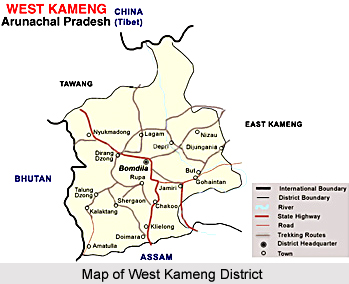
 Geography of West Kameng district is spread over higher mountainous zone consisting of a mass of tangled peaks and valleys. This district of Arunachal Pradesh accounts for near about 8.86 per cent of the total area of this state. Under the Chinese sovereignty claim, West Kameng district falls under the jurisdiction of Cuona County of Shannan Prefecture of the Tibet Autonomous Region. This district shares an international border with Tibet in the north, Bhutan in the west, Tawang in the northwest, and East Kameng district in the east. The southern border of West Kameng district is shared with Sonitpur district and Darrang district of Assam.
The landscape of the West Kameng district is mostly mountainous. In the West Kameng there are three major mountain chains - part of Sela range, Bomdila range and Chaku range. The Sela range consists of a series of mountains arranged in the form of a big line from Tibet in the north to Bhutan in the west and hence forming a tough territory to pass through. The elevation of Sela range varies from 14,000 to 15,000 feet and Sela pass is around 13,714 feet high. The Bomdila range has an average height of 9000 feet. In the south of Bomdila range there is the Chaku range having hills of quite low heights and is full of tropical forests. Tenga, Bichom and Dirang Chu are the main rivers flowing through the West Kameng district. All these rivers are tributaries of the Kameng River which flows through Bhalukpong circle of this district and joins the Brahmaputra River in the plains of Assam.
The inhabitants of the West Kameng district comprises mainly of Monpa tribe, Miji tribe, Sherdukpen tribe, Aka tribes, and Bugun tribes. The Monpas belong to the Tibeto-Mongoloid stock and are the largest tribe of this district, inhabiting mainly in Dirang and Kalaktang circles. The Mijis are settled in Nafra and Akas are settled in Thrizino circle. The Khawas or Buguns inhabit the Wanghoo, Kaspi, Singchung and Tenga areas. The Sherdukpens are mainly settled in four villages of Rupa, Jigaon, Shergaon, Thongre and also in Doimara area. By and large the inhabitants of this district are the followers of Buddhism though Akas, Khawas and Mijis also believe in indigenous religion and follow partly Buddhism and Hinduism practices. Every tribe has its own society and village council. Regular passenger services to Guwahati, Tezpur, Itanagar, Tawang and all the circle head quarters of the district are being provided by State Transport and private buses. Bhalukpong is the nearest railway station in the West Kameng district situated at around 100 kms from the Bomdila, while Salonibari (in Tezpur) is the nearest airport located at around 160 kms from the district head quarters. The wonderful topography of West Kameng district makes it a beautiful tourist destination of the country.


