Introduction
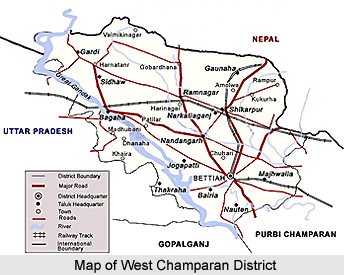 West Champaran District is one of the 38 administrative districts of Bihar. Bettiah is the district headquarters. West Champaran District is located between 26 degree 16 minutes and 27 degree 31 minutes north latitude and 83 degree 50 minutes and 85 degree 18 minutes east longitude. This district is bounded by the hilly region of Nepal in the north, by Gopalganj District and part of East Champaran District in the south, by East Champaran District in its east and by Padrauna District and Deoria District of Uttar Pradesh. Total area of West Champaran District is 5228 sq kms.
History of West Champaran District
According to historical accounts, West Champaran District was formed out of Champaran District in 1972. Initially, West Champaran District was a sub-division of Saran District and then Champaran District. Old district of Champaran is a disintegrated version of Champaka aranya, as this region was a forest tract in the past.
Geography of West Champaran District
 Geography of >West Champaran District is divided into few distinct tracts. The first consists of the hilly tract of Sumeswar and Dun range in the north at the foothills of Himalayas. It is noticeable that the soil even at the foot of the hills has no rocky formation and wherever water can be impounded, a rich growth of crop is possible. The hilly streams, however, play havoc by bringing down huge quantities of sand and destroying cultivable lands. The hills contain large stretches of forests. Next to the hilly area comes the Terai region, which is largely populated by Tharu Tribe of the district. The Terai region is followed by fertile plains occupying the rest of the district. This plain itself is divided into two well defined tracts by the little Gandak and have markedly distinct characteristics. The northern portion is composed of old alluvium and has a considerable area of low land.
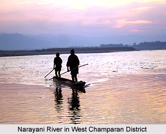
A number of streams flowing southwards traverse geography of West Champaran District. The southern portion of the tract is characterized by stretches of upland varied in places by large marshy depressions known as `chaurs`. The Gandak or Narayani and Sikrahana are the two important rivers of this district.
Geography of West Champaran District includes a cool climate as compared to the adjoining districts of the state. The terai area comprising mainly Ramnagar, Bagaha and Narkatiaganj is considered unhealthy while all other areas have a healthy climate. Winter begins in November and lasts till February, followed by hot summer months when temperature rises to maximum 43 degree Celsius. Rains set in during the later part of June. The district receives some winter rain also. Rainfall is heavier than most of the districts and is especially heavy in the terai region.
However, West Champaran District has recently suffered large scale denudation of forests. Forests are confined to the northern tract and particularly the Sumeswar and the Dun ranges are covered with forests. Tirhut, Tribeni and Done canals are the most prominent canals operating in this district. The Dun and Sumeswar hills in the extreme north, which are the continuation of Shivalik hill range, are formed of ill compacted sandstone. There are beds of Kankar (sandstone) in parts of the district and saltpetre is found almost everywhere.
Education in West Champaran District
West Champaran District has a literacy rate of 39.63 percent. There are a few schools in the district, which are amongst the best in North Bihar. Number of government primary schools in the district is 1340; number of Middle Schools is 284 and number of High Schools is 68 (including Minority and Project Schools), number of constituent colleges is 3 and there is one Industrial Training Institute.
Economy of West Champaran District
Agriculture is the main source of income of the people in West Champaran District. Some agro-based industries have flourished here and are being run successfully. Sugar mills are established at Majhaulia, Bagaha, Ramnagar, Narkatiaganj, Chanpatia and Lauria. Some rice mills are also being run successfully and the produce is being marketed to different places outside the district. Cottage industries based on local available natural and agricultural produce catering the local needs such as basket, rope, mat weaving etc. are also popular. Mainly three types of crops are produced in this district - Bhadai (autumn crop), Aghani (Kharif) and Rabbi (spring crop). Bhadai crops comprise mainly Maize and Sugarcane. The main crops of Aghani season are paddy, potato etc. Wheat, Barley and Arhar are main Rabi crops. Main crop of the low lying land in northern region of the district is paddy. This district depends a lot on livestock for cultivation.
Tourism in West Champaran District
 Tourism in West Champaran District is composed of several places of religious and historical interests. Tourism in West Champaran District comprises visits to various attractions like historical forts, archaeological remains and temples. People from all parts of the country come and explore the various tourism places offered by this district of Bihar. Some of the most popular tourist attractions of West Champaran District are as follows -
Pilgrimage Tourism in West Champaran District
Triveni Confluence: This place is in the north-western part of the district under Bagaha-II Block. Panchanand and Sonaha are attractive places to see. This place is at the Indo-Nepal border. One bank of this confluence touches Triveni village of Nepal while another bank extends to Bhaisa Lotan village of the district. The holy book "Srimad Bhagwat" describes that the thousand years battle between Gaj (Elephant) and Grah (Crocodile) was started at this place. Lord Vishnu appeared and protected the elephant. Every year a fair is held at this holy place on the eve of "Magha Sankranti" (Magha is the 11th month of the Hindu lunar calendar and `Sankranti` refers to the period of time when Sun enters into a new zodiac sign).
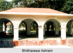
Bhitiharawa Ashram: It is a village in Gaunaha block from where Mahatma Gandhi started his freedom movement that came to be known as `Champaran Satyagraha` in India history.
 Leisure Tourism in West Champaran District
Bawangarhi: It means 52 forts. This name is given to the remains of some old fortifications near Darwabari in Bagaha-II block about 8 kms from Triveni. The place is also called Tripan Bazar. The remains of the 52 forts and 53 bazaars are at a short distance to the north of the village. To the north-west across the swamp are remains of massive embankments, which may perhaps have been intended to serve as reservoirs.
Sumeswar: A fort is situated on the summit of the Sumeswar hills, at a height of 2,884 feet above sea level, in Ramnagar block. The fort which stands on the edge of a sharp precipice is now in ruins, but its remains are well defined and reservoirs cut out of the solid rocks, in which water was stored for the use of the inhabitants, can still be seen. The ridge upon which Sumeswar Fort is situated offers a magnificent view of the snow and of the intervening valleys and low hills situated in Nepal. The ridge here forms the boundary between West Champaran and Nepal. The great Himalayan peaks of Dhaulagiri, Gosainthan and Gaurishanker are all clearly visible, and the view is said to be one of the finest views in the country.
Vrindavan: Situated at a distance of 10 kms from Bettiah, in Gaunaha Block, this village had the honour of being the venue of the annual conference of `All India Gandhi Seva Sangh` in 1937. It was attended by Mahatma Gandhi and Rajendra Prasad.
Nandangarh and Chankigarh: Nandangarh is situated in Lauria block while Chankigarh is situated in Narkatiaganj block. These are actually two big mounds, which are the remains of palaces of Nanda Dynasty.
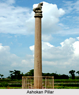
Ashoka Pillars: About 1 km east of Nandangarh in Lauria block is the lion pillar of Ashoka, over 2300 years old and is in excellent condition. This pillar is 35 feet in height, its base diameter is 35 inches, and upper diameter is 22 inches. Its massiveness and exquisite finish furnish striking proof of the skill and resources of the masons of Ashokan age. Two more such pillars have been discovered in Rampurwa village, close to Gandhi`s Bhitiharawa Ashram in Gaunaha block.
Nature Tourism in West Champaran District
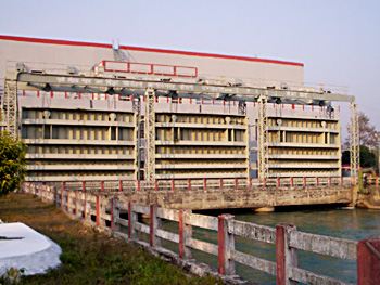
Valmikinagar: - Formally known as Bhainsa Lotan, it is a famous tourist spot where a dam is built on river Gandak known as Gandak Project. This dam and its channels are the lifeline of north-western part of Bihar. This channel also irrigates some portions of eastern Uttar Pradesh. This dam is also generating hydro-electricity. For those, who are interested in exploring natural beauty, a visit to the sylvan surroundings of Valmilkinagar is a must; where the gushing streams of Gandak break the ascetic calm of the Himalayan foothills. Bhainsa Lotan is also famous for Valmiki Ashram where Valmiki, the author of Ramayana, is said to have spent some years. Lord Shiva temple, constructed by Bettiah Raj and ancient Shiv-Parvati temple is also situated here.
 Bhiknatohari: A beauty spot located in Gaunaha block on the northern part of the district, is the last railway station on Narkatiaganj Bhiknathori section. Located in the midst of beautiful scenery, it gives a clear view of the snow capped Himalaya Mountains and the Annapurna peak in the winter.
Saraiya Man: Situated at a distance of about 6 kms from Bettiah town, Saraiya Man is a lake which is a wonderful tourism spot. The lake attracts diverse varieties of birds.
These places of interest of West Champaran District are worth visiting as they offer a memorable travelling experience to the visitors.


