 Geography of Tirunelveli district in Tamil Nadu possesses various types of forests. The total geographical area of the district of Tirunelveli is six thousand eight hundred and twenty three square kilometres. It is located between eight degree eight minutes and nine degree twenty three minutes to the North latitude and seventy seven degree nine minutes and seventy seven degree fifty four minutes to the East longitude. This district is also termed as a microcosm of the state of Tamil Nadu because of its mosaic and diverse physical and geographical features like lofty mountains and low plains, rivers, dry Teri structures and cascades, seacoast and thick inland forest, fertile alluvial and sandy soils, an assortment of flora, fauna, and protected wild life.
The district of Tirunelveli is having its borders as the Gulf of Mannar, the Indian state of Kerala, the Virudhunagar district, Thoothukudi district and the Kanyakumari district. The total wet land of this district is seventy nine thousand six hundred and sixty eight hectares while the dry land is about 3, 58,151 hectares and the forest area covered in this district is about 1,22,055 hectares.
The type of weather in the Tirunelveli district is quite hot in the months of May and June and the maximum temperature during this period sometimes reaches forty five degree Celsius. With the onset of the southwest monsoon by the end of the month of May or during the beginning of June, some drop in the temperature is registered. Main rainy season is from October to the middle of January. The average rain fall in the district is 814.8 mm per annum.
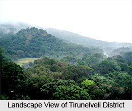
The total area of the forest of Tirunelveli district is 1, 22,055 hectares of which 81700 hectares is set apart for Tiger reserve of Mundanthurai and Kalakadu. The whole forest of the district stretches along the Western Ghats. Several types of forests from luxuriant tropical wet evergreen forests to southern thorn scrub forests occur in this district due to its diverse geographical factors. The forests in the district of Tirunelveli are technically classified as Southern hill top tropical evergreen forests, Southern moist mixed deciduous forests, West Coast tropical evergreen forests, Ochlandra reed forests, Carnatic umbrella thorn forests Southern Euphorsia scrub and Southern thorn scrub. There are several rivers which flow in this district including Tamiraparani, Pachaiyar, Chittar, Korayar, Aluthakanniar, Aintharuviar, Ramanathi, Gadananathi, Mundhal Odai, Jambunathi, Hanumannathi, Gundar, Mottaiyar, Karuppanathi, Manimuthar, Karunaiyar, Nambiyar, Vedamaliyaru, Kothaiyaru, Kottamalaiyaru and Rajasingiyaru rivers.


